|
| |
|
HOME >
Monitoring and Data >
Oceanic & Atmospheric Data >
Northern Hemisphere Teleconnection Patterns >
North Pacific (NP)
|
| |

|
| |
|
Notice: In order to eliminate inconsistencies
between the monthly and daily teleconnections, NOAA’s Climate Prediction Center is currently revising the manner in which both sets of indices are
calculated. This will significantly alter the historical archive of the following indices: NAO, EA, EA-Jet, WP, EP, NP, PNA, EATL/ WRUS and SCAND. The
AO and AAO indices will not be affected and their historical archives will remain unchanged. The new indices are expected to become
operational on 1 June 2005.
|
| |
| |
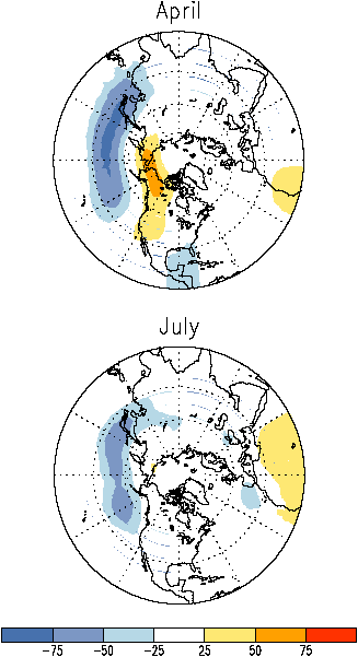
Map (Positive Phase) |
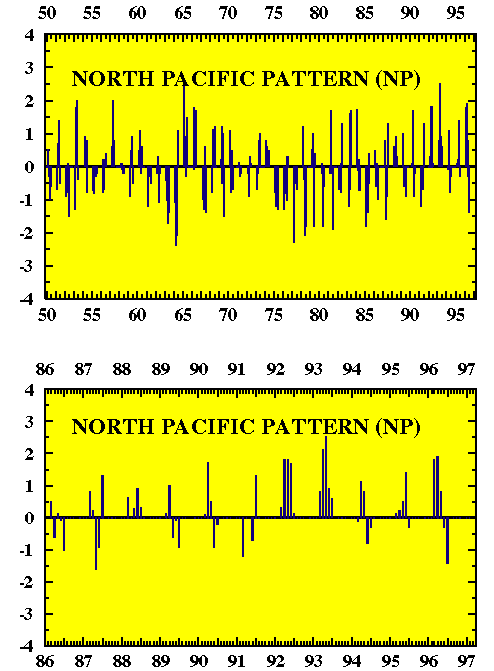
Plotted Historical Time Series : (January 1950-February
1997) |
| Monthly Tabulated indices Part II:
Last 12 months of indices for selected teleconnection patterns, as appears in the
Climate Diagnostics Bulletin. |
| Plotted Recent Monthly Time Series
|
| Table Archive of
Indices Dating Back to 1950 |
| Back to contents |
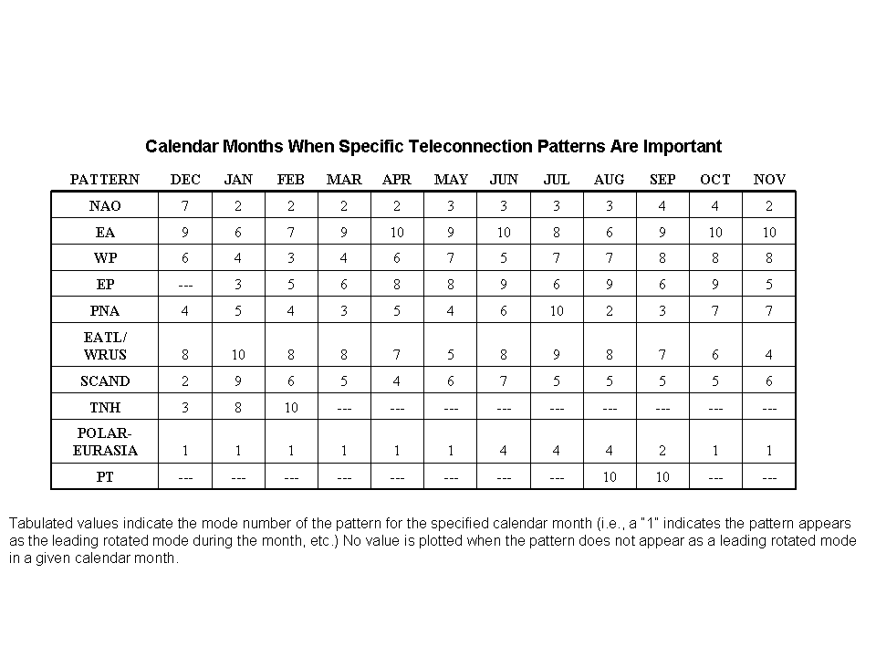
| Table showing Calendar months when specific teleconnection
patterns are important |
|
| The North Pacific pattern is
prominent from March through July. This pattern consists of a primary anomaly center which
spans the central latitudes of the western and central North Pacific, and weaker anomaly
region of opposite sign which spans eastern Siberia, Alaska and the intermountain region
of North America. Overall, pronounced positive phases of the NP pattern are associated
with a southward shift and intensification of the Pacific jet stream from eastern Asia to
the eastern North Pacific, followed downstream by an enhanced anticyclonic circulation
over western North America, and by an enhanced cyclonic circulation over the southeastern
United States. Pronounced negative phases of the NP pattern are associated with
circulation anomalies of opposite sign in these regions. Bell and Janowiak (1995) recently
noted that a positive phase of the NP pattern reflects one of the preferred responses of
the extratropical atmospheric circulation to ENSO during the Northern Hemisphere spring.
This response was particularly evident during the 1992 and 1993 spring seasons, when a
prolonged positive phase of the NP pattern dominated the circulation.
Bell and Janowiak also note that the
atmospheric circulation during the several month period prior to the onset of the Midwest
floods of June-July 1993 was dominated by the most pronounced and persistent positive
phase of the NP pattern in the historical record. Their study concluded that these
conditions were indirectly important to the onset and overall magnitude of the
floods, since they fostered an anomalously intense storm track over the midlatitudes of
the North Pacific. Dramatic changes in this storm track during June then ultimately
initiated the Midwest floods. |
|
|
|


