Warm (El Nino/Southern Oscillation - ENSO) and Cold Episodes
Interannual variations of ocean surface temperatures in the equatorial central and eastern Pacific have been linked to persistent regional and global atmospheric anomalies. A large scale abnormal warming in the equatorial Pacific is called El Nino, a term which also refers to the large scale atmospheric effects related to the warming. This phenomenon is closely related to a global atmospheric oscillation known to scientists as the Southern Oscillation (SO). During El Nino episodes lower than normal pressure is observed in the eastern tropical Pacific and higher than normal pressure is found over Indonesia and northern Australia. These conditions characterize the warm phase of the SO, which is often referred to as an El Nino/Southern Oscillation (ENSO) episode. During periods when ocean surface temperatures are colder than normal (the cold phase of the SO), lower than normal pressure is found over Indonesia and higher than normal pressure is observed over the eastern tropical Pacific.
During warm (ENSO) and cold episodes the normal pattern of tropical precipitation becomes disrupted. This affects tropical atmospheric circulation features, such as the jet streams in the subtropics and in the temperate latitudes of the winter hemisphere. The jet streams over the Pacific Ocean are stronger than normal during a warm episode and weaker than normal during a cold episode. Also, during warm and cold episodes extratropical storms and frontal systems follow paths that are significantly different from normal, resulting in persistent temperature and precipitation anomalies in many regions.
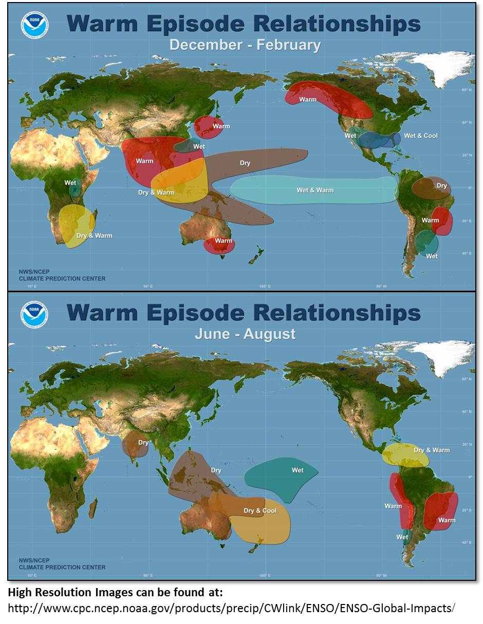
By studying past warm and cold episodes scientists have discovered precipitation and temperature anomaly patterns that are highly consistent from one episode to another. Significant anomalies are shown in the accompanying figures for the Northern Hemisphere winter and summer seasons. Within the tropics, the eastward shift of thunderstorm activity from Indonesia into the central Pacific during warm episodes results in abnormally dry conditions over northern Australia, Indonesia and the Philippines in both seasons. Drier than normal conditions are also observed over southeastern Africa and northern Brazil, during the northern winter season. During the northern summer season, the Indian monsoon rainfall tends to be less than normal, especially in northwest India where crops are adversely affected. Wetter than normal conditions during warm episodes are observed along the west coast of tropical South America, and at subtropical latitudes of North America (Gulf Coast) and South America (southern Brazil to central Argentina).
During a warm episode winter, mid-latitude low pressure systems tend to be more vigorous than normal in the region of the Gulf of Alaska. These systems pump abnormally warm air into western Canada, Alaska and the extreme northern portion of the contiguous United States. Storms also tend to be more vigorous in the Gulf of Mexico and along the southeast coast of the United States resulting in wetter than normal conditions in that region.
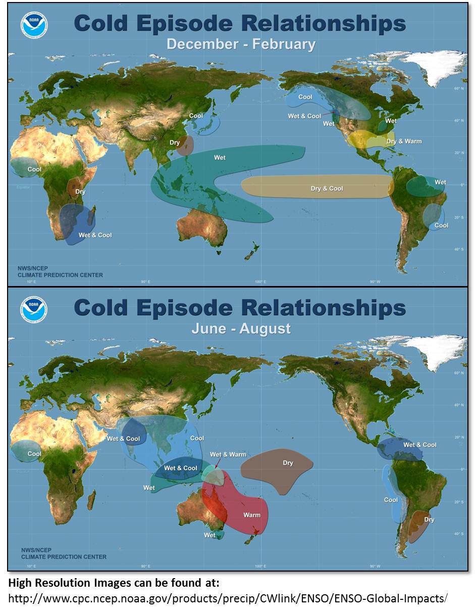
During cold episodes, the colder than normal ocean temperatures in the equatorial central Pacific act to inhibit the formation of rain-producing clouds over that region. Wetter than normal conditions develop farther west over northern Australia and Indonesia, during the northern winter, and over the Philippines during the northern summer. Wetter than normal conditions are also observed over southeastern Africa and northern Brazil, during the northern winter season. During the northern summer season, the Indian monsoon rainfall tends to be greater than normal, especially in northwest India. Drier than normal conditions during cold episodes are observed along the west coast of tropical South America, and at subtropical latitudes of North America (Gulf Coast) and South America (southern Brazil to central Argentina) during their respective winter seasons.
Mid-latitude low pressure systems tend to be weaker than normal in the region of the Gulf of Alaska, during a cold episode winter. This favors the build-up of colder than normal air over Alaska and western Canada, which often penetrates into the northern Great Plains and the western United States. The southeastern United States, on the other hand, becomes warmer and drier than normal.
Since anomaly patterns during warm and cold episodes tend to persist for several months, accurate long-range forecasts (1 to 3 seasons) are possible for the regions shown in the accompanying figures. For the latest information on the status of ENSO go to the ENSO Advisory (issued when appropriate) or the latest monthly Climate Diagnostics Bulletin.
More technical information on the global patterns of abnormal precipitation and temperature related to warm and cold episodes in the tropical Pacific can be found in Ropelewski and Halpert (1987, Mon. Wea. Rev., 115, 1606-1626); 1989, J. Climate, 2, 268-284), and Halpert and Ropelewski (1992, J. Climate, 5, 577-593). A general description of a warm (ENSO) episode and its composite evolution can be found in Rasmusson and Carpenter (1982, Mon. Wea. Rev., 110, 517-528). Upper-tropospheric circulation features that accompany extreme phases of the Southern Oscillation are discussed in a paper by Arkin (1982, Mon. Wea. Rev., 110, 1393-1404).