
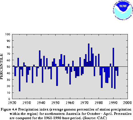
The rainy season over northern and eastern Australia typically lasts for seven months, beginning in October and ending in April. Much of the area receives over 75% of its mean annual precipitation during this period, and parts of extreme northern Australia record more than 90% of the mean annual precipitation during this period. For the 1993/94 wet season as a whole, precipitation over northeastern Australia averaged near the 40th percentile (Fig. 4.4). Generally 250 - 750 mm of rain fell on the northern and eastern sections of the continent, although much larger amounts (1250 - 1900 mm) were recorded in northern Arnhem Land and the southeastern Cape York Peninsula.
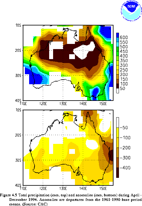
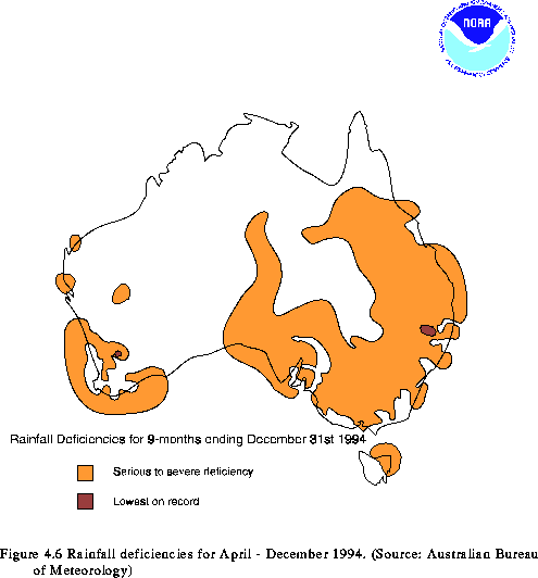
The 1993/94 rainy season ended earlier than normal (March) and was followed by the development of severe precipitation deficits and extreme drought over much of Australia during the next nine months (Fig. 4.5). During this nine-month period, sections of eastern Australia accumulated rainfall deficits in excess of 200 mm (Fig. 4.5, bottom), and eastern Queensland and the northern portion of the Cape York Peninsula recorded deficits exceeding 300 mm. Farther south, southern and southwestern Australia recorded 100-200 mm deficits during the period. By the end of the year, severe drought conditions covered northeastern, east-central and southeastern Australia, and portions of the southwest (Fig. 4.6).
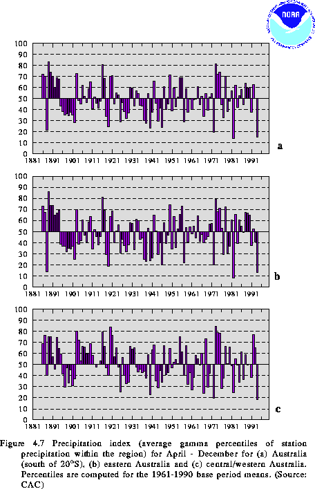
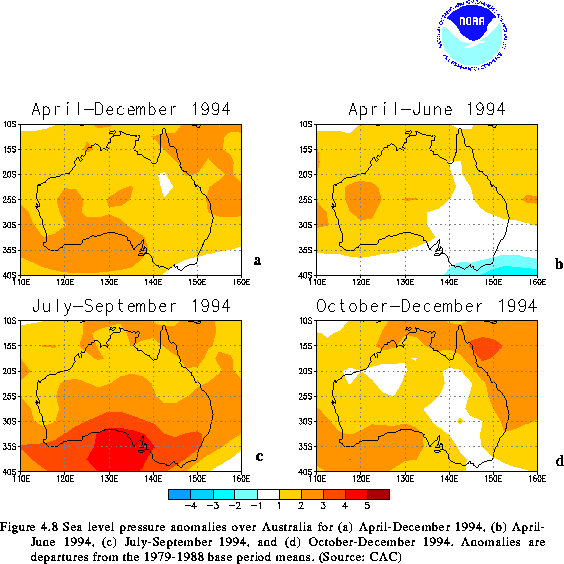
Overall, precipitation totals during 1994 were the second lowest of the century (Fig. 4.7a), with the driest year being 1982. Eastern Australia also recorded its second driest year of the century during 1994 (Fig. 4.7b), while central/western Australia recorded its driest year of the century (Fig. 4.7c). These severe drought conditions were attributed to the reemergence and subsequent intensification of ENSO conditions in the tropical Pacific (see section 2), in combination with a persistent pattern of above-normal heights and pressure (Fig. 4.8) throughout the extratropical latitudes of the continent.
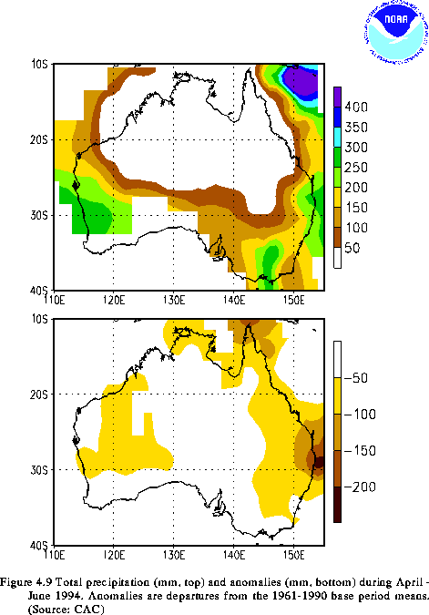
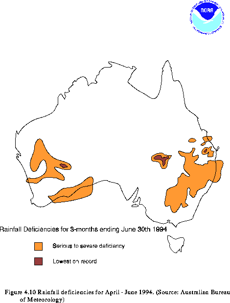
During April-June, the circulation was dominated by above-normal heights in the southwest and by above-normal pressure throughout the west (Fig. 4.8b). These conditions reflected an enhanced anticyclonic circulation over Australia and a poleward shift of the mean jet stream and storm track to well south of the continent. Accompanying this circulation, significantly below- normal precipitation fell throughout eastern Australia and over large portions of the west (Figs. 4.9). For example, precipitation deficits exceeded 100 mm over extreme eastern Queensland and northeastern New South Wales, and averaged 50-100 mm over the eastern one-quarter of the continent and throughout the west (Fig. 4.9b). By the end of June, serious to severe precipitation deficiencies were reported over portions of southeastern Queensland and over large areas of central New South Wales, with isolated areas in these states reporting the most severe drought conditions in the historical record (Fig. 4.10). Farther west, serious to severe precipitation deficiencies were also reported over portions of central Western Australia at this time.
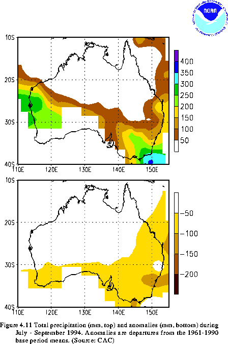
During July-September, above-normal heights and above-normal surface pressure continued throughout Australia (Fig. 4.8c). Pressures averaged 2-3 mb above normal over most of the continent, and 3-5 mb above normal in the extreme south. Accompanying this circulation, the climatological long-wave trough normally located near 110E tended to be weaker than normal and was displaced well west of normal (near 80-100E). These conditions were associated with a poleward shift and weakening of the storm track between the east Indian Ocean (equatorward of 40S) and the Great Australian Bight. These factors, combined with an overall weaker magnitude of midlatitude frontal systems, resulted in well below-normal rainfall (Fig. 4.11) and a continuation of drought conditions over large areas of southern and eastern Australia. This situation was exacerbated by a general lack of significant tropical moisture incursions over the continent, which normally contribute considerable rainfall in inland areas. The entire eastern and southern portions of the continent recorded 50-100 mm precipitation deficits during July-September. These conditions were particularly acute during August, when the entire eastern half of Australia recorded one of their driest Augusts on record.
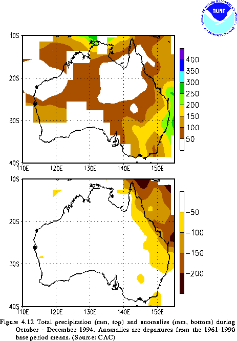
During October-December substantially below-normal rainfall was confined to the northeast (Fig. 4.12), and near-normal precipitation totals were observed over much of the southeast and south. During November, several good rainfall episodes brought much-needed, but very short-term, relief to southwestern Queensland and northern/central New South Wales. However, by the end of the year, severe drought had again redeveloped in these regions. In the northeast, the pattern of significantly below-normal rainfall during September-December indicated a weak onset to the 1994/95 wet season. Additionally, with the northern and eastern parts of the continent in the midst of their primary growing season as the year ended, the ongoing drought threatened to severely impact agricultural and hydrological interests in these areas.
![]() Regional Climate Summaries: Indian Summer Monsoon
Regional Climate Summaries: Indian Summer Monsoon
![]() Regional Climate Summaries: Southern Africa
Regional Climate Summaries: Southern Africa
![]() Table of Contents
Table of Contents


