
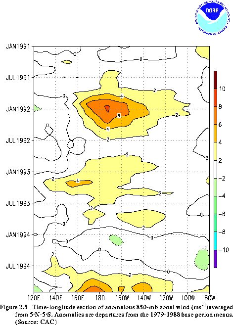
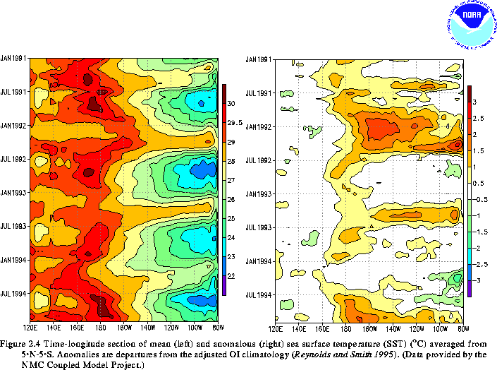
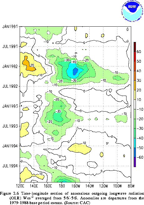
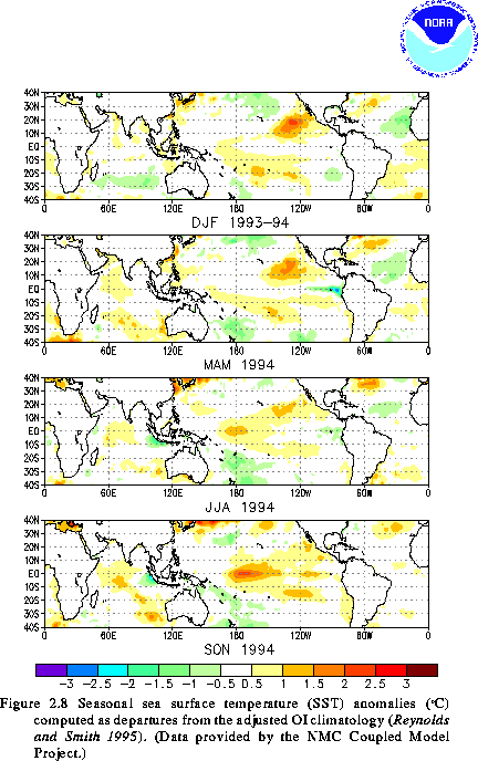
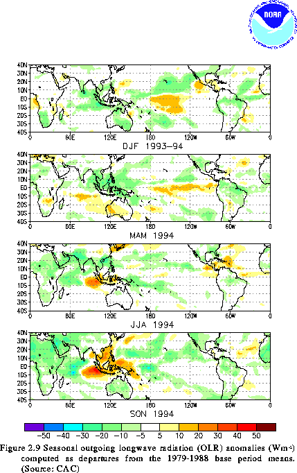
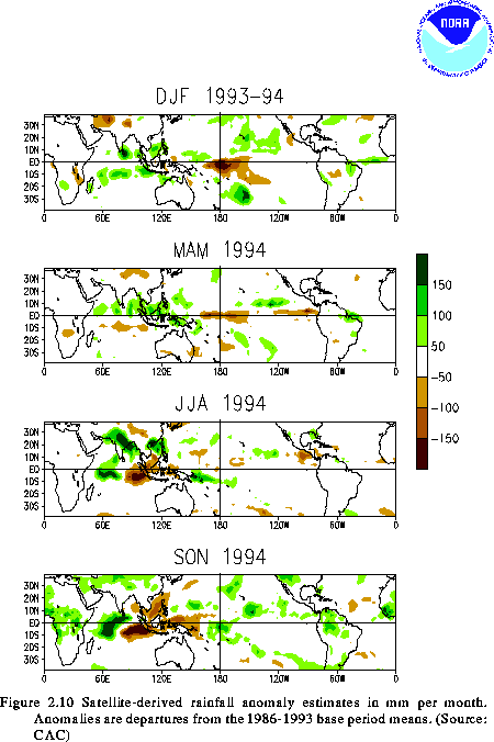
By late 1993 the low-level equatorial easterlies had become slightly stronger than normal (Fig. 2.5), positive SST anomalies in the vicinity of the date line had decreased (Fig. 2.4, right), and convective activity in the central tropical Pacific was slightly weaker than normal (Fig. 2.6). During the next three months (December-February 1993/94), SSTs finally returned to near-normal throughout the entire equatorial Pacific (Fig. 2.8a). This evolution was accompanied by the development of above-normal convection over western Indonesia and the eastern Indian Ocean, and by a continuation of weaker than normal convection over the central equatorial Pacific (Figs. 2.9 and 2.10). These conditions, along with a further strengthening of the equatorial easterlies throughout the Pacific (Fig. 2.5), supported coupled model and statistical predictions of the possible evolution toward cold episode conditions during the next year.
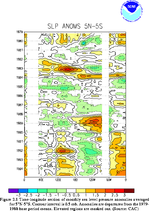
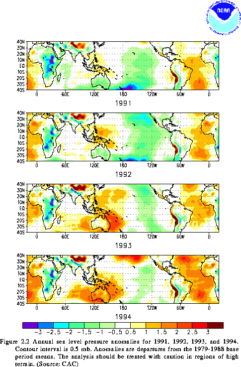
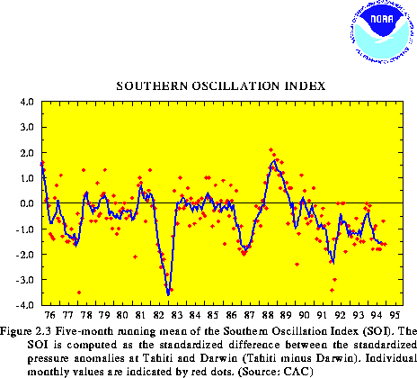
However, two important features remained unchanged during December-February, indicating that warm episode conditions had not completely disappeared. First, large areas of positive SST anomalies remained in the subtropics of both hemispheres east of the date line (Fig. 2.8a). Second, the previously described pattern of anomalous SLP persisted throughout the global tropics during the season (Figs. 2.1 and 2.2), despite a return to near-zero values of the SOI (Fig. 2.3).
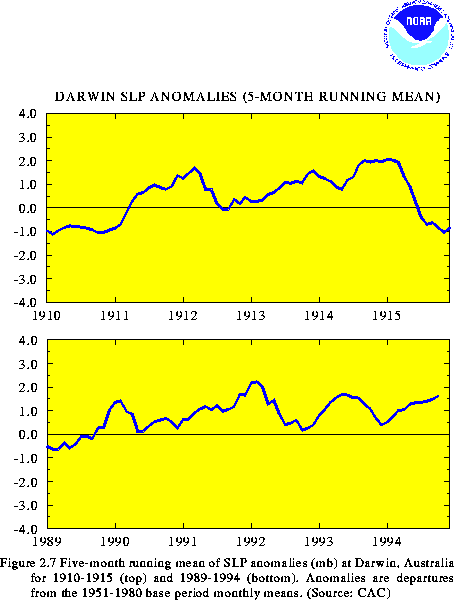
During the March-May season, sea level pressure anomalies at Darwin increased (Fig. 2.7, bottom), the SOI decreased to -1.5 (Fig. 2.3), and the equatorial easterlies once again weakened (Fig. 2.5). During May, positive SST anomalies reappeared along the equator near the date line (Fig. 2.4, left), consistent with a further weakening of the equatorial easterlies over the central and east-central Pacific (Fig. 2.5). Overall, these conditions indicated a trend away from possible cold episode conditions during the upcoming year. However, they remained inconclusive as far as indicating a return toward mature ENSO conditions in the upcoming 1994/95 boreal winter season.
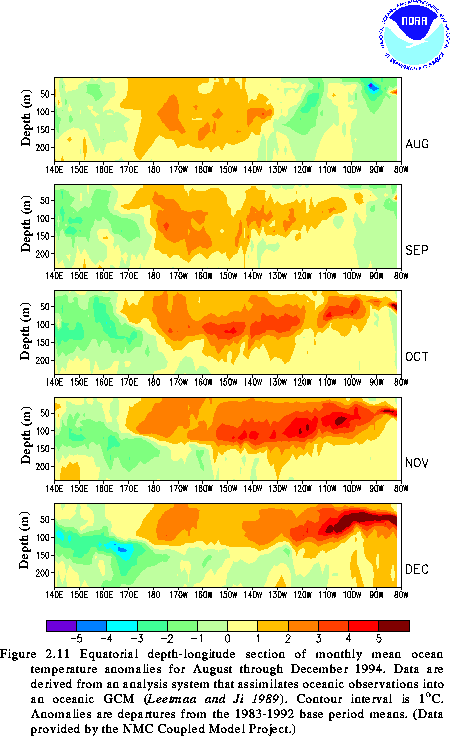
During June-August, positive SST anomalies continued to increase and spread eastward across the central equatorial Pacific (Figs. 2.4, right and 2.8). This evolution was consistent with a gradual eastward shift of the warmest equatorial water (greater than 30C) to the vicinity of the date line (Fig. 2.4, left) and with a deepening of the oceanic thermocline and an increase in subsurface ocean temperature anomalies in the east-central equatorial Pacific (Fig. 2.11). By August, SST anomalies averaged 1.0-1.5C above normal along the equator between 170E and 160W. This increase was accompanied by weaker than normal easterlies throughout the central and east- central equatorial Pacific (Fig. 2.5) and by sustained negative values of the SOI, which again averaged -1.5 during the season (Fig. 2.3).
In the past, these features have collectively been good indicators of developing warm episodes. In fact, by August, coupled ocean-atmosphere and statistical model guidance indicated continued warmer than normal conditions through early 1995. These indications, together with atmospheric and oceanic trends, suggested that warm episode conditions would intensify and that a mature warm episode would develop by early 1995.
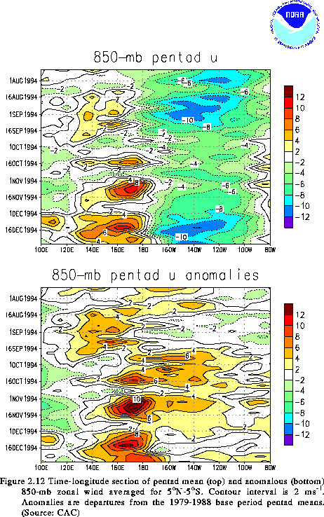
During September-November, a rapid intensification and eastward spread of positive SST anomalies was indeed observed between the date line and 160W (Figs. 2.4 and 2.8), where anomalies averaged 2-2.5C above normal. This increase was accompanied by a further weakening of the low-level equatorial easterlies over the central equatorial Pacific (Fig. 2.12), particularly during late September and most of October. At times the 850-mb winds were nearly calm or even westerly (westerly wind bursts, Fig. 2.12, top), especially in the central Pacific near the date line. This pattern favored reduced upwelling in the upper ocean in the eastern equatorial Pacific, resulting in a deepening of the equatorial oceanic thermocline, an increase in subsurface temperature anomalies (Fig. 2.11), and an increase in SST anomalies everywhere east of the date line (Figs. 2.4, right and 2.8). These conditions were accompanied by the development of enhanced convection in the vicinity of the date line and the equator (Fig. 2.9) and by a continuation of below-normal convective activity and drought throughout Indonesia (Fig. 2.10) and large portions of Australia (see section 4.b).
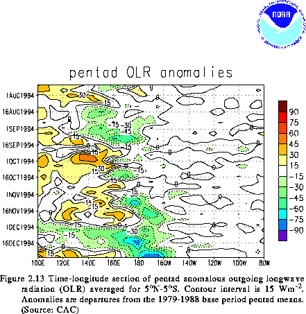
Although these changes indicated an accelerated evolution toward mature warm episode conditions, convective activity in the central equatorial Pacific was quite variable during September and October in association with intraseasonal (30-60 day) oscillations (Fig. 2.13). Finally, during November and December persistent and enhanced convective activity, indicating the onset of mature ENSO conditions, became established in the vicinity of the date line. Thus, 1994 ended with a dramatic return to mature ENSO conditions for the third time in four years.
![]() Seasonal Summaries: December - February
Seasonal Summaries: December - February
![]() Oceanic and Atmospheric Anomalies Related to ENSO:
Oceanic and Atmospheric Anomalies Related to ENSO:
Large-scale Conditions In The Tropics 1990-1994
![]() Table of Contents
Table of Contents


