
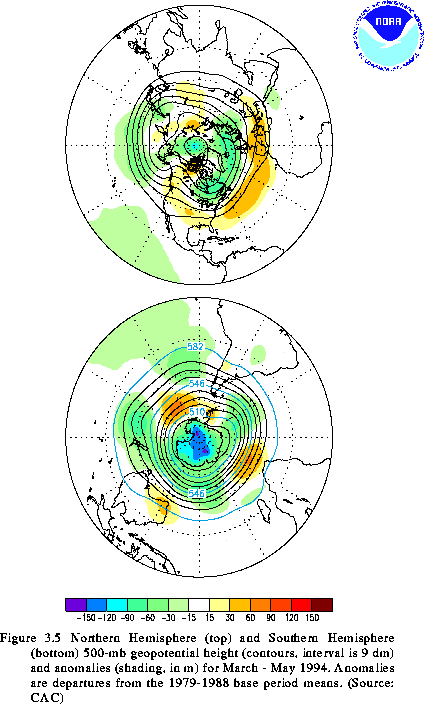
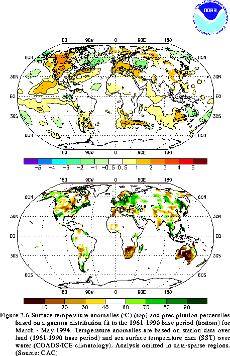
Northern Hemisphere
In the Northern Hemisphere, the circulation during March-May 1994 (MAM) was characterized by negative height anomalies at 500 mb over the central latitudes of the North Pacific, eastern Canada, and the high latitudes of the North Atlantic, and by positive height anomalies over much of the United States, the central North Atlantic, and Europe (Fig. 3.5. top). Major surface features included abnormally warm and dry conditions over large portions of western North America, southern Europe, and China, and abnormally wet conditions over the eastern United States, northern Europe, and Southeast Asia (Fig. 3.6).
Over North America, above-normal heights and temperatures, and below-normal precipitation, dominated large portions of the western United States and western Canada. Temperatures averaged 1-3C above normal throughout this region, with the largest anomalies observed in western Canada. Overall, the abnormally dry conditions throughout the West during MAM typified the entire western U.S. rainy season (October through April) (see section 4).
Below-normal precipitation was also observed over large portions of the central United States during MAM, with parts of the central Plains and Midwest recording one of their driest MAM seasons in the historical record. In the Midwest, MAM 1994 marked the first season since the great Midwest floods (June-August 1993) in which below-normal precipitation was observed.
The circulation over the North Atlantic and Europe during MAM was again characterized by negative height anomalies at high latitudes and by positive height anomalies throughout the central latitudes. These conditions reflected a continuation from the winter season of the positive phase of the North Atlantic Oscillation and were again associated with anomalously warm surface temperatures throughout central and southern Europe and the Middle East, and with excessive precipitation throughout northern and western Europe and portions of western Russia. In contrast, precipitation deficits over southern Europe accumulated during the season, as much of this region received its second consecutive season of significantly below-normal precipitation.
During MAM, much of China experienced a continuation of above-normal (1-2C) temperatures that developed during DJF. Large portions of interior China also recorded below-normal rainfall for the second consecutive season. In contrast, eastern Manchuria and eastern Siberia experienced a continuation of above-normal precipitation that began during DJF. These conditions were associated with an overall northward and eastward shift of the entrance region of the Pacific jet stream toward northern Manchuria.
Southern Hemisphere
In the Southern Hemisphere, major surface features during MAM 1994 included abnormally warm conditions over southwestern Australia and anomalously dry conditions over virtually all of Australia and large portions of South Africa (Fig. 3.6). The atmospheric circulation during MAM was marked by below-normal heights throughout the Antarctic and by an anomalous zonal wave-3 pattern in the middle latitudes, with above-normal heights influencing large portions of Australia and South Africa (Fig. 3.5, bottom).
The pattern of above-normal heights over southwestern Australia and below-normal heights farther south reflected an enhanced anticyclonic circulation and above-normal surface pressure throughout the continent. This circulation was accompanied by a pronounced poleward shift of the mean jet stream and storm track to well south of the continent. These conditions were associated with near-record precipitation deficits throughout Australia during the season (see section 4).
Over the southern African sector, a large area of positive height anomalies was centered to the south of the country. This feature was accompanied by an anomalous anticyclonic circulation and large rainfall deficiencies throughout South Africa. Farther east, Madagascar was hit by two additional hurricanes during March. Hurricane Litanne made landfall on 17 March with sustained winds of 56 m/s, and hurricane Nadia made landfall on 23 March with sustained winds of more than 50 m/s. Since 1 January, most of the country had received 800-1700 mm of rain, with the largest amounts falling on the eastern coastline in the vicinity of the hurricane/ tropical cyclone landfall locations.
![]() Seasonal Summaries: June - August
Seasonal Summaries: June - August
![]() Seasonal Summaries: December - February
Seasonal Summaries: December - February
![]() Table of Contents
Table of Contents


