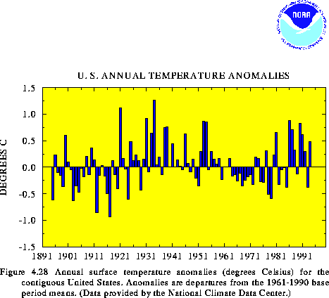
According to preliminary estimates, the mean annual surface temperature over the contiguous United States during 1994 was 0.48C above the long-term mean (Fig. 4.28). Thus, 1994 ranked as the 16th warmest year on record since 1895. More than 25% of the nation recorded annual temperatures in the upper 10th percentile during the year, while none of the country recorded significantly colder-than-normal conditions. The warmth was found mainly in the West, which averaged in the upper one-third of the 100-year historical record. In contrast, near-normal temperatures covered much of the country east of the Mississippi River. Above-normal temperatures have dominated the United States during the past 9 years (Fig. 4.28), although temperatures during 1993 averaged much below normal.
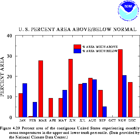
On a monthly basis, above-normal temperatures dominated large parts of the country during March, June, and December, while unusually cold conditions were observed in February (Fig. 4.29). Remarkably, no regions experienced significantly below-normal temperatures during March, April, June, October, and December. October was unusual in that virtually none of the contiguous United States experienced either much-above or much-below temperatures.
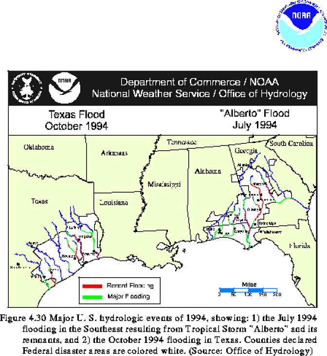
Two major flood events dominated the precipitation anomalies during 1994. The first event occurred in July, when tropical storm Alberto crossed the Florida Panhandle. Maximum sustained winds peaked at 29 m/s at the time of landfall on July 3. The storm caused torrential rainfall throughout the eastern Gulf coast region, with the largest totals exceeding 700 mm at Americus, Georgia. Record flooding was observed along portions of several large river systems in Georgia, Alabama, and Florida (Fig. 4.30) during the storm, and damages were estimated at $750 million, including at least $100 million in agricultural losses.
The second event occurred in southeastern Texas during mid-October, in association with sustained tropical rainfall focused along a stationary frontal zone. Local totals exceeded 750 mm, and much of southeastern Texas recorded more than 150 mm during this period. Record flooding occurred along six major rivers and their tributaries (Fig. 4.30), and damages were estimated in the hundreds of millions of dollars.
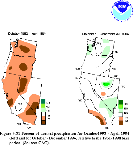
In the western United States, the 1993-94 wet season brought below-normal precipitation (less than 50% of normal) to large portions of Washington, Oregon, California and Nevada (Fig. 4.31, left). Intermittent severe-to-extreme drought conditions have persisted over large parts of the Pacific Northwest and California during the past decade.
During the onset of the 1994-95 wet season (Oct - Dec), precipitation averaged above normal over much of Washington, Oregon, Nevada, and California (Fig. 4.31, right) and was substantially larger than observed during the past several years. Additionally, heavy snow fell over large portions of western Washington, Oregon, and northern California during October-December 1994, resulting in a much above-normal snowpack water content throughout these regions. This precipitation helped to significantly alleviate drought conditions over large parts of the West.
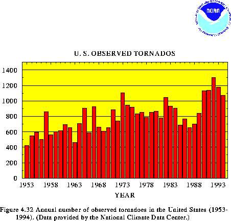
According to preliminary data from the National Severe Storms Forecast Center of the National Weather Service, 1073 tornadoes were observed across the contiguous United States during 1994 (Fig. 4.32). This compares with the 1953-1993 average of 791 tornadoes per year and represents a decrease of more than 200 tornadoes from the peak year of 1992. It should be noted that the preliminary tornado count is usually higher than the final count, and that tornado observations have generally improved with time.
3) 1994 Atlantic Hurricane Season
Below-normal hurricane activity dominated the 1994 Atlantic hurricane season (June - November), and the net tropical cyclone activity was only 37% of the average of the last 45 years. Three systems, all tropical storms (Alberto, Beryl, and Gordon), affected the southeastern United States coast during the season. There were three hurricanes (maximum sustained wind greater than 30 m/s) during the season, although none were of major intensity (winds greater than 49 m/ s), and a total of seven named storms (hurricanes and tropical storms combined). Normally, six hurricanes (two of major intensity) and 10 tropical storms are observed during the season.
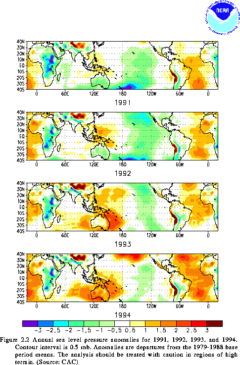
A suppression of hurricane activity has been observed during each of the past four years. Only two hurricanes have formed equatorward of 25N, instead of the expected 14 hurricanes during this time. This lack of hurricane activity is linked to a persistent pattern of above-normal pressure throughout the tropical and subtropical Atlantic (Fig. 2.2), to prolonged warm episode conditions in the tropical Pacific (see section 2.a), and to enhanced upper-level westerlies over the Caribbean basin throughout the period (W. Gray, personal communication).
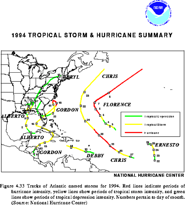
Tracks of the seven named storms during 1994 (Fig. 4.33) are color-coded to delineate the periods when each storm was a hurricane, tropical storm and tropical depression. Brief characteristics of these storms, numbered as shown in Fig. 4.33, are:
1. Tropical Storm Alberto (30 June- 7 July): Formed west of Cuba and made landfall in the Florida Panhandle. Alberto stalled over west-central Georgia and was notorious for its tremendous flooding in Georgia, Florida, and Alabama.
2. Tropical Storm Beryl (14-19 August): Formed in the northern Gulf of Mexico and also made landfall in the Florida Panhandle. Beryl caused considerably less flooding than Alberto, although tornadoes caused significant damage in South Carolina and Virginia.
3. Hurricane Chris (16-23 August): First hurricane of the season (weak) formed in the low-latitudes of the central Atlantic. The fringes of Chris caused heavy rains in Bermuda.
4. Tropical Storm Debby (9-11 September): Formed from an African wave near the central Antilles. Debby dissipated as it moved westward into the eastern Caribbean. The storm caused fatalities and extensive damage in St. Lucia and Martinique.
5. Tropical Storm Ernesto (21-26 September): Formed in the eastern Atlantic. It moved northward in response to an upper-level trough and dissipated west of the Cape Verde Islands.
6. Hurricane Florence (4-9 November): Formed in the central Atlantic and was the first November hurricane since 1986. Florence reached category 2 intensity and was the season's most intense hurricane. No major land masses were affected by the hurricane.
7. Gordon (10-20 November): First named storm in the Caribbean and second hurricane during November. Gordon followed an erratic path over Nicaragua, the western Caribbean Sea, Jamaica, Cuba, the Bahamas, Florida, and the southwestern North Atlantic. Gordon's torrential rains produced disastrous flooding and mud slides, which were particularly deadly in Haiti. Estimates of the death toll ranged up to 2000 in that country. In Florida, seven deaths were attributed to Gordon, with significant agricultural damage.
Figure 4.28 Annual surface temperature anomalies (degrees Celsius) for the contiguous United States. Anomalies are departures from the 1961-1990 base period means. (Data provided by the National Climate Data Center.)
Figure 4.29 Percent area of the contiguous United States experiencing monthly mean temperatures in the upper and lower tenth percentile. (Data provided by the National Climate Data Center.)
Figure 4.30 Major U. S. hydrologic events of 1994, showing: 1) the July 1994 flooding in the Southeast resulting from Tropical Storm "Alberto" and its remnants, and 2) the October 1994 flooding in Texas. Counties declared Federal disaster areas are colored white. (Source: Office of Hydrology)
Figure 4.31 Percent of normal precipitation for October1993 - April 1994 (left) and for October - December 1994, relative to the 1961-1990 base period. (Source: CAC).
Figure 4.32 Annual number of observed tornadoes in the United States (1953- 1994). (Data provided by the National Climate Data Center.)
1994 TROPICAL STORM & HURRICANE SUMMARY