In general, the classic ingredients for wintertime flooding are a heavy snowpack over nearly saturated or frozen ground, followed by a rapid rise in temperature and heavy rain. The wet and warm weather contributes to significant snow melt, resulting in very large runoff that often leads to flooding. Such conditions resulted in flooding of the Willamette and Columbia Rivers in the Northwest during February 1996 and also in large-scale flooding throughout the Pacific Northwest during December 1996. They also resulted in river flooding in the Northeast and mid-Atlantic states during mid-January 1996 [section 4b(3).]
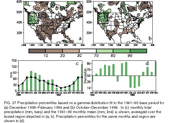
These first two flooding events occurred in association with a persistent and much larger pattern of above-normal precipitation in the Northwest and below-normal precipitation in the Southwest and central plains (Figs. 37a,b). This large-scale anomaly pattern is opposite to that which persisted during the first half of the 1990s. This interannual variability in precipitation can be linked to large-scale changes in the atmospheric circulation resulting partly from the demise of warmepisode conditions in early 1995 and from the subsequent transition to cold-episode conditions by mid-1995 (see section 3a). This transition was accompanied by a pronounced poleward shift of the jet stream, storm track and abnormally heavy rainfall to the northwestern United States, approximately 18° north of their mean position over the southwestern United States during the previous several winters (see Halpert et al. 1996, their Fig. 34).
5-9 February 1996 flooding of the Willamette and Columbia Rivers
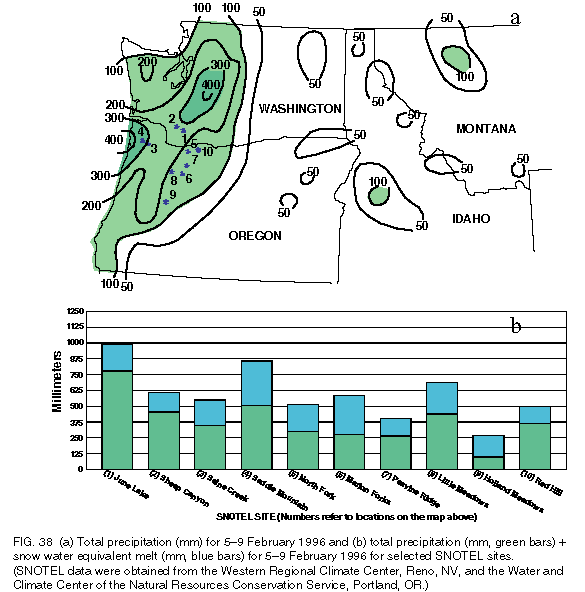
Exceptionally heavy seasonal precipitation (125%-175% of the mean) dominated Washington, Oregon, Idaho, and northern California during DJF 1995/96, with seasonal totals exceeding the gamma-based 80th percentile in the area of significant flooding in northwestern Oregon and southeastern Washington (Fig. 37a). The most significant flooding event of this rainy period occurred during 5-9 February 1996 when significant rain fell at all but the highest elevations. During this 5-day period rainfall totals exceeded 100 mm throughout the region and averaged 250-400 mm at many locations (Fig. 38a).
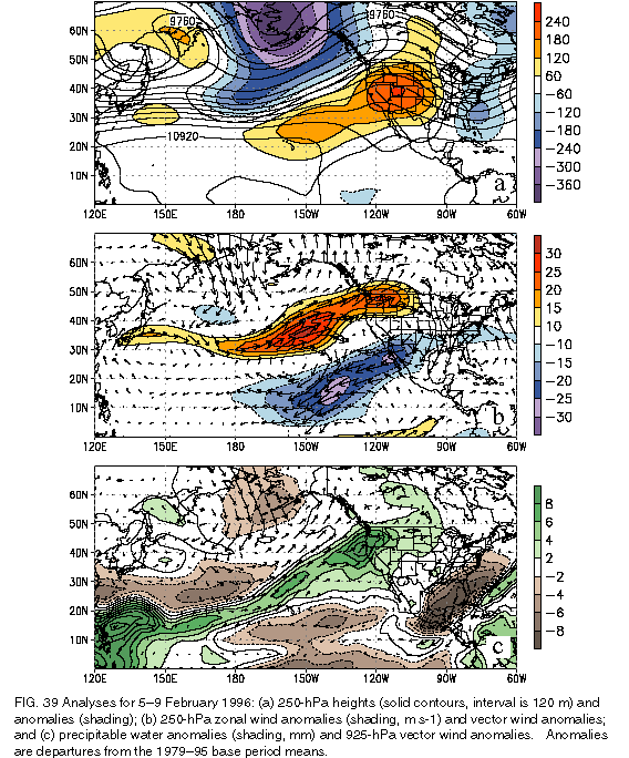
The atmospheric circulation during 5-9 February was characterized by a large-amplitude trough extending southward from western Alaska and a large-amplitude ridge centered over the intermountain region of the western United States (Fig. 39a ). This pattern was accompanied by very strong southwesterly flow extending from the region north of Hawaii to the Pacific Northwest throughout the depth of the troposphere (Figs. 39b,c). This strong subtropical connection brought abundant moisture (Fig. 39c), excessive rainfall, and a very rapid temperature rise to the Northwest. These conditions also caused a rapid snowmelt (in excess of 1250 mm over a few days), resulting in a liquid water (rainfall plus snow melt) runoff of more than 500 mm in many areas, more than 975 mm at June Lake in southern Washington, and more than 850 mm at Saddle Mountain in northwestern Oregon (Fig. 38b). Runoff, combined with nearly saturated soil conditions from more than 3 months of above-normal precipitation, resulted in severe flooding west of the Cascade Mountains, particularly along the Willamette and Columbia Rivers.
During these floods, most locations along the Willamette River reported river levels 3.3-5.7 m above flood stage (the highest since 1964 at most locations), with the largest departure from flood stage occurring near Oregon City. In addition, the Columbia River crested approximately 2.5-4.7 m above flood stage between Longview and Vancouver, Washington. As a result of these floods, approximately 60 counties in Oregon, Washington, Idaho, and Montana were declared Federal disaster areas.
Late-December 1996 flooding in the Northwest
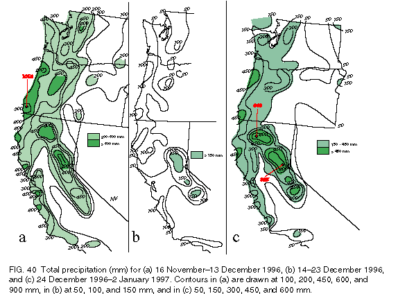
Primary contributors to the northwestern U. S. flooding in late-1996 were saturated soils and well above normal snowpack and snowpack water content throughout the region, which resulted from above-normal precipitation during October-December (Figs. 37b-d). Precipitation for the period exceeded 150% of the mean throughout the Northwest, with the heaviest monthly mean precipitation occurring in December when area-averaged totals reached twice the mean and exceeded the gamma-based 95th percentile throughout the region (Fig. 37d). Overall, many areas in the Pacific Northwest, northern California, and the Sierra Nevada received more than 1000 mm of precipitation during October-December (Fig. 40), with some orographically favored areas recording in excess of 1500 mm. In addition, large portions of coastal central California received more than 750 mm of rain during the period, while large portions of Idaho, eastern Washington, and eastern Oregon received 300-600 mm of precipitation.
Most of the precipitation fell during two distinct periods in November and December. The first period lasted from 16 November to 13 December (Fig. 40a), which culminated in localized flooding in mid-December. During this period, much of western Oregon and large portions of the Sierra Nevada received precipitation exceeding 600 mm, while more than 200 mm were recorded throughout the rest of western Oregon, western Washington, and coastal northern and central California. By 13 December, 6-week precipitation totals were 125-400 mm above the mean in parts of the northern Sierra Nevada, western Oregon, and portions of northwestern Washington.
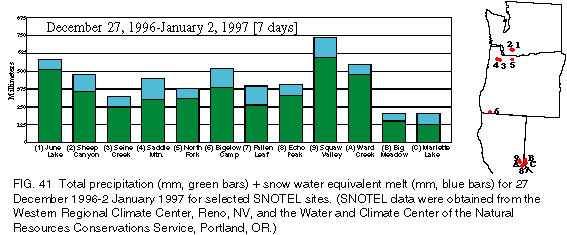
Over the next 10 days (14-23 December), cooler and drier conditions dominated the Northwest, with the heaviest precipitation (50-100 mm) falling primarily as snow across western Washington, western Oregon, and northern and eastern California (Fig. 40b). This period was followed by a rapid increase in temperature and a return to excessive precipitation during the next 10 days (24 December 1996-2 January 1997), with 450-825 mm of precipitation falling on orographically-favored areas and more than 150 mm falling elsewhere throughout the affected region (Fig. 40c). Due to the extremely warm weather during the period, much of this precipitation fell as rain. This wet and warm weather produced significant snow melt at lower and middle elevations, resulting in severe flooding throughout the Northwest and the higher elevations in California. During this period, the liquid water runoff (rainfall plus snowmelt) exceeded 300 mm in many areas (Fig. 41) and reached a maximum of 580 mm in Squaw Valley, California.
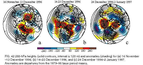
The circulation features during the three periods are shown in Fig. 42. The first heavy precipitation period was characterized by below-normal heights at upper levels of the troposphere over southwestern Canada (Fig. 42a) and jet stream winds (not shown) averaging 10-15 m s-1 stronger than normal across Oregon, northern California, and southern Idaho. At low levels, abnormally strong southwesterly flow covered the western United States during the period, bringing a series of major storms with abundant moisture into the western United States.
The subsequent transition to cooler and drier conditions during the 10-day period ending 23 December resulted from the development of strong northwesterly flow at upper levels throughout the northwestern United States (Fig. 42b) and a concurrent drop to below-normal moisture levels throughout the region. This evolution occurred in association with the onset of strong ridging across the high latitudes of the North Pacific and North Atlantic Ocean basins and with the formation of an abnormally deep trough of low pressure across central North America (Fig. 42b).
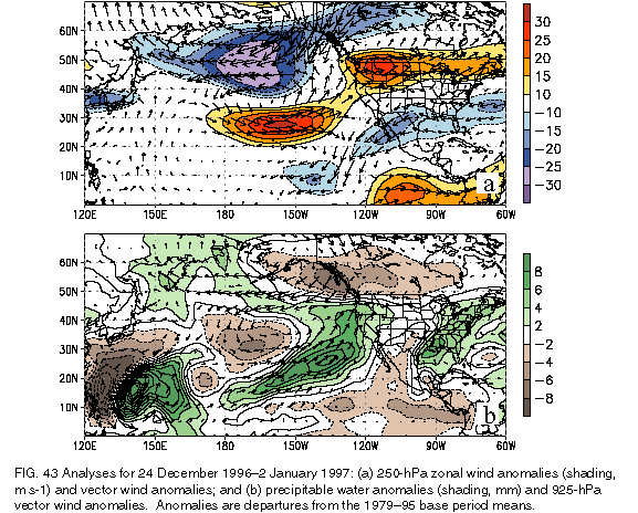
During the 10day period ending 2 January 1997, a well-defined blocking pattern became established over the central and eastern North Pacific (Fig. 42c). This pattern featured a very strong low-latitude jet stream flow (20-30 m s-1 above normal) south of the mean ridge in the vicinity of Hawaii (Fig. 43a) and enhanced southwesterly flow extending from the subtropical North Pacific to the northwestern United States. This flow directed a series of major storms, with very warm air and significant moisture from the deep subtropics, well into the western United States (Fig. 43b). The pattern also featured a strong trough over western Canada (Fig. 42c), which contributed to abnormally strong northerly flow over the eastern Gulf of Alaska. This feature combined with the enhanced subtropical flow to produce very strong frontal systems and enhanced frontal-type precipitation, further increasing precipitation totals throughout the Northwest.
The above analysis indicates that heavy precipitation observed in the Northwest during November and December resulted from two essentially distinct flow patterns, each of which brought major storms and moisture from the subtropics into the region. The first was a more east-to-westoriented pattern of abnormally strong jet stream winds across the Northwest, which directed a series of major storms through the region. The second pattern featured a strongly blocked flow at high latitudes of the North Pacific Ocean and an amplified low-latitude flow throughout the depth of the troposphere, which emanated from the subtropical North Pacific and extended directly into the northwestern United States.
The variability in the atmospheric circulation over the eastern North Pacific Ocean and the northwestern United States during November and December was likely related in part to intense MJOs across the western tropical Pacific (see section 3b). For example, satellite imagery confirmed that the strong southwesterly flow of warm, moist air into the Northwest in late December actually extended westward to the western tropical Pacific and emanated from the region of enhanced tropical convection associated with the MJO.