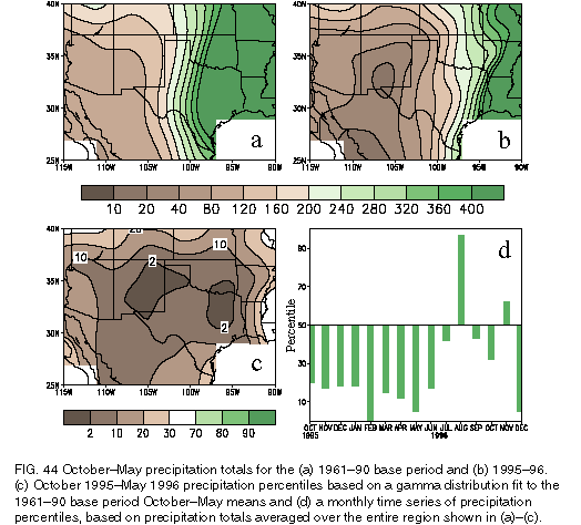
Climatologically, precipitation is rather low over the southwestern United States during October-May, with totals averaging only 80-160 mm in most areas (Fig. 44a). Mean totals increase farther east to more than 400 mm across the eastern half of Texas, the eastern half of Oklahoma, and southeastern Kansas. Nonetheless, drought began to develop across the southwestern United States, the southern plains states, and northern Mexico during October 1995 and by May 1996 had severely affected Arizona, Kansas, New Mexico, Oklahoma, and Texas. Overall, the drought resulted in a substantial deterioration of many of the region's crops and pastures, destroying nearly the entire unirrigated winter wheat crop in New Mexico and rendering 90% of the state's sorghum crop in poor or very poor condition. Fortunately, the impact of the drought on reservoirs, lakes, and rivers was relatively minor. However, notable exceptions were the Rio Grande River and its reservoirs, and water supplies and stream flows across northern Mexico, all of which reached record or nearrecord low levels during the period.
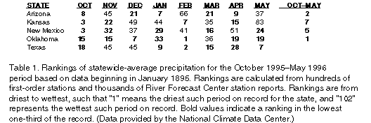
For the region as a whole, precipitation averaged below the 30th percentile in each of the 9 months from October 1995 through June 1996 (Fig. 44d). Exceptionally scant totals of less than 25 mm were observed across southwestern Texas, the southern half of New Mexico, and western Mexico, with portions of south-central New Mexico and northern Mexico receiving less than 10 mm total precipitation during the period (Fig. 44b). Farther east, October-May totals were less than the 10th percentile over most of the region (Fig. 44c). Oklahoma recorded its driest October-May period on record dating to 1895, while Texas and Arizona reported their second driest such period (Table 1). In fact, there were only two monthly, state wide precipitation rankings in the drought region that were above-median during this period: Arizona during February and Kansas during May.
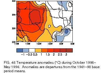
The drought in the Southwest was aggravated by above-normal temperatures, very low humidity, and frequently windy conditions. Temperatures averaged more than 2.0°C above normal throughout New Mexico and western Arizona during the period (Fig. 45) and 1.0°-2.0oC above normal elsewhere in the Southwest.
Drought conditions evolved somewhat differently in various parts of the affected region. For example, exceptionally little precipitation was recorded during the entire October 1995-May 1996 period from the southwestern high plains westward across the Southwest and northern Mexico. In the northwestern quarter of Texas and much of Oklahoma, well below normal October through mid-March precipitation was measured, but amounts increased thereafter. In late April, the first significant precipitation in months fell in west-central Texas, and during the latter half of May widespread light to moderate rains fell on most of central and northeastern Texas and much of Oklahoma. However, this rainfall was only near or slightly below normal for the period and failed to alleviate drought conditions in these regions.
Farther south across southern and eastern Texas, moderate to heavy precipitation (200-350 mm) fell during October-December 1995, but exceptionally low totals were subsequently reported during January-May 1996. In fact, the state of Texas as a whole reported its driest such January-May period on record, with Brownsville, Texas, measuring only 20 mm of precipitation during the period.
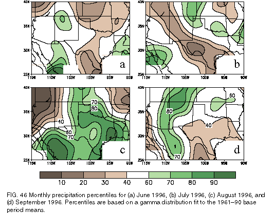
The drought finally began to abate in New Mexico and portions of northwestern Mexico during June, as precipitation totals reached the 60th and 70th percentiles across the region (Fig. 46a). The heaviest and most widespread rains since September 1995 fell across New Mexico and adjacent areas during 11-16 June, with between 12.5 and 30 mm falling on most of the eastern half of the state and 50-90 mm falling on portions of east-central New Mexico.
Subsequently, above-normal rainfall developed across the Texas panhandle and the Baja peninsula
during July (Fig. 46b), with near-normal rainfall persisting across New Mexico. By mid-July, the accumulated
October 1995-May 1996 precipitation deficit had been completely eliminated in parts of New Mexico and
was halved in northern Texas and portions of western Oklahoma. Elsewhere, widespread relief from the
drought came in August and September (Figs. 46c,d), with August precipitation totals exceeding the 90th
percentile over much of eastern Texas and reaching the 70th-80th percentiles across western Oklahoma, western
Kansas, eastern New Mexico, and virtually all of northern Mexico (Fig. 46c). Much of this precipitation
was
associated with Hurricane Dolly in mid-August, which produced rainfall totals in excess of 200 mm in
many areas. For much of this region, these totals were more than the entire accumulated precipitation
observed between January and July 1996. During September, the primary region of above-normal rainfall shifted
westward to northwestern Mexico, western New Mexico, and eastern Arizona, and continued over large
portions of western Oklahoma and western Kansas (Fig. 46d).
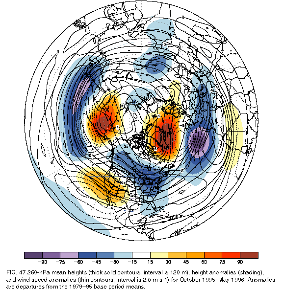
The drought was but one manifestation of an extremely persistent planetary-scale circulation pattern that extended from the North Pacific across North America to eastern Europe during October 1995-May 1996 (Fig. 47). This pattern featured above-normal heights over the high latitudes of the North Pacific and throughout the southwestern United States, and below-normal heights across the central latitudes of the North Pacific, throughout Canada, and across the eastern United States (Fig. 47).
Over the North Pacific, these anomalies reflected significant blocking activity at high latitudes, along with enhanced westerlies across the central latitudes. The enhanced Pacific jet stream extended into the northwestern United States, where mean southwesterly and westerly wind speeds at upper levels averaged more than 6 m s-1 above normal (Fig. 47). This flow pattern directed the mean storm track into the Pacific Northwest, resulting in reduced storm activity, frontal activity, and precipitation across the Southwest throughout the 8-month period. Also, one expects descending motion between the ridge and downstream trough axes in a typical midlatitude wave and ascending motion between the trough and downstream ridge axes. During October-May 1995/96, the entire drought region was centered between the large-scale mean ridge and trough axes, in a region of enhanced, descending motion and reduced precipitation.
An apparent phase-locking of two prominent climate factors provides a partial explanation for the extreme duration of the planetary-scale circulation pattern observed during the drought. These factors are 1) coldepisode conditions in the tropical Pacific, and 2) an extremely persistent negative phase of the North Atlantic oscillation. Mature-phase coldepisode conditions favor an enhanced upper-level ridge over the high latitudes of the North Pacific and over the eastern North Pacific/southwestern United States and, thus, a northward displacement of the jet stream and storm track over the western United States (Livezey et al. 1997). These conditions favor below- (above-) normal precipitation across the Southwest (Pacific Northwest), consistent with that observed during October-May 1995/96. Farther east, below-normal heights are favored across Canada and the northern tier of the United States during cold-episode conditions (Livezey et al. 1997), reflecting an overall amplification of the climatological-mean Hudson Bay trough.
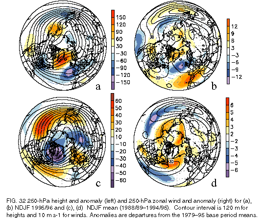
A strong and persistent negative phase of the NAO also reflects an amplification of the mean Hudson Bay trough, as well as a southward extension of the trough into the east-central United States (Figs. 32a, 47 ). Thus, it appears that the circulation features associated with both the Pacific cold episode and the negative phase of the NAO tended to reinforce each other over eastern North America during the October-May period, resulting in the extremely persistent and coherent planetary-scale circulation pattern that extended from the central North Pacific eastward to southern Europe. In addition to the drought in the Southwest and southern plains states, other manifestations of this persistent pattern included 1) above-normal precipitation in the northwestern United States during November 1995-February 1996 [see section 4b(1)], 2) an abnormally cold and snowy winter across the Great Lakes region and the northeastern United States [see section 4b(3)], and 3) anomalous temperature and precipitation patterns throughout Europe (see section 4a).