Issued 10 August 1999
There is a strong likelihood of above-average tropical storm and hurricane
activity over the North Atlantic basin during the upcoming peak of the hurricane season,
according to a consensus of scientists at the National Oceanic and Atmospheric
Administration's (NOAA) Climate Prediction Center (CPC), National Hurricane Center (NHC)
and Hurricane Research Division (HRD). There is also a stronger likelihood of at least
three major hurricanes (corresponding to categories 3-4-5 on the Saffir-Simpson scale)
during this period. This statement reiterates a similar outlook issued by NOAA on 27 May, 1999.
This Outlook should be used as a guide of overall expected activity for the Atlantic
basin. It does not give any indication of whether a particular locality will be impacted
by a tropical storm or hurricane during 1999. Residents and government agencies of coastal
or near-coastal regions should always maintain normal hurricane preparedness efforts
regardless of the overall outlook for a given year.
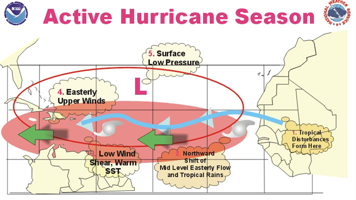
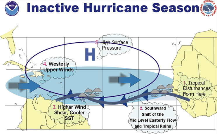
Many of the most prominent atmospheric and oceanic factors that are thought to be conducive to Atlantic basin tropical storm and hurricane activity
are already in place, and are expected to persist through the season. Thus, we feel that
there is a comparatively small chance that the 1999 season will turn out to be inactive. These factors are 1) low vertical wind shear across
the tropical Atlantic, 2) below-average air pressure across the tropical Atlantic and
Caribbean, 3) a structure and location of the African easterly jet which is thought to be
more efficient for providing energy to developing tropical systems as they propagate
westward from the African coast, and 4) above-average sea-surface temperatures across the
tropical Atlantic and Caribbean Sea.
The expected continuation of these conditions is based on their strong link to existing
patterns of tropical rainfall and tropical Pacific Ocean temperatures, both of which are
expected to persist through the remainder of the hurricane season. This expectation is not
based on global warming associated with elevated carbon dioxide levels. The ongoing
pattern of tropical rainfall features above-normal rains across Indonesia and the eastern
Indian Ocean, and a near-absence of rainfall across the central and eastern equatorial
Pacific. These conditions are consistent with the continuing pattern of below-normal
sea-surface temperatures over the central and eastern tropical Pacific (La Nina), and
strongly influence the atmospheric circulation throughout the global Tropics and
subtropics. Over the tropical Atlantic the impact of these conditions is often a
large-scale and persistent pattern of atmospheric wind and pressure that is conducive to
an active hurricane season.
Two additional factors that are typically observed during active hurricane seasons, but
which are not yet in place, are 1) reduced wind shear over the Caribbean Sea and 2) a
northward extension of deep tropical moisture and rainfall to the hurricane development
region. These additional factors often accompany the four conditions enumerated above, and
are expected to develop during the upcoming weeks. This expectation represents the primary
source of uncertainty for this Outlook, since these two factors will ultimately play an
important role in determining whether the 1999 season is active or near normal.
Only one tropical storm has been observed over the Atlantic basin since June. This low
number of systems is normal for this time of the year when atmospheric and oceanic
conditions are generally unfavorable for tropical storm development. This inactivity is
not a reliable indicator of conditions during the remainder of the season. Moreover, even
active years often feature alternating periods of activity and inactivity during the
August-November period.
During active hurricane seasons, the continental United States usually experiences more
landfalling hurricanes than average. The Caribbean region is also far more at risk of
experiencing a tropical storm or hurricane during active seasons than at other times, as
was recently observed during the 1995, 1996, and 1998 seasons. In an average season the
United States experiences 1-2 landfalling hurricanes, while the Caribbean Islands
experience 1 hurricane.
The hurricane season for the North Atlantic basin (which includes the North Atlantic
Ocean, Caribbean Sea and Gulf of Mexico) officially runs from June 1st through November
30th. For the August- November period the average number of systems reaching tropical
storm status (maximum sustained winds between 39-73 mph), hurricane status (maximum
sustained winds of at least 74 mph) and major hurricane status (maximum sustained winds
exceeding 110 mph) are eight, five and two, respectively.
This outlook is not designed to compete with other hurricane outlooks issued by groups
outside of NOAA. We gratefully acknowledge the pioneering research of Dr. William Gray and
others, which has significantly increased scientific understanding of the association
between the various climate factors (particularly the ENSO cycle) and the atmospheric
circulation features that affect Atlantic basin hurricane activity. We also acknowledge
the leading role that Dr. Gray and colleagues at the Colorado State University have played
in developing and providing seasonal forecasts of Atlantic basin tropical storm and
hurricane activity.
CAUTIONARY NOTES:
1) Far more damage can be done by one major hurricane hitting a heavily populated area
than by several major hurricanes hitting sparsely populated areas or, of course, not
making landfall at all. Because of this, hurricane spawned disasters can occur even in
relatively inactive years from landfalling systems.
2) Increased tropical storm and hurricane activity during a particular year does not
automatically mean increased storm-related damage. For example, in 1992 Hurricane Andrew,
the only major hurricane to develop in that relatively inactive year, caused over $25
billion in damage to the continental United States. In contrast there was less than $4
billion in damage to the continental United States during 1995, one of the most active
seasons on record.
3) Although major hurricanes tend to be the deadliest and costliest tropical systems,
disasters can and indeed do occur due to flooding from less intense hurricanes and
tropical storms.
|


