[Previous Article]
[Next Article]
Assessing Upper Limits of Seasonal Predictability of Rainfall
in Central Chile Based on SST in the Equatorial
Pacific
contributed by Patricio Aceituno and Aldo Montecinos
Department of Geophysics, Universidad de Chile,
Casilla 2777, Santiago, Chile
Rainfall in central Chile (30 Ł 35ES) occurs mostly during
the austral winter (MayŁAugust), when occasional midlatitude fronts reach
this subtropical region located between the Andes Cordillera and the Pacific
coast. During the rest of the year, dry conditions prevail as the entire
subtropical area is under the permanent influence of the South Pacific
anticyclone. Several studies have confirmed the significant influence of
the Southern Oscillation (SO) on the interannual rainfall variability in
this region, with a tendency for abundant winter rainfall during El NiZo
episodes. Mechanisms explaining this association have to do with the weakening
of the subtropical anticyclone and an increase in blocking episodes to
the southwest of the continent during the negative SO phase (Rutllant and
Fuenzalida 1991). Diagnostic studies have also revealed a significant tendency
for less than normal precipitation during La Nina episodes when the subtropical
anticyclone is anomalously strong, thus blocking the entrance of fronts
to central Chile.
Based on these relationships, a seasonal forecast of rainfall
during the austral winter was developed for central Chile using a canonical
correlation analysis (CCA) as described in Barnett and Preisendorfer (1987).
Sea surface temperature (SST) in the region 150EE Ł 80EW, 20EN Ł 40ES,
with a grid resolution of 4.5 x 7.5 (lat Ł lon) was used to predict rainfall
at 15 Chilean stations between 30 and 40ES during the wet season (MayŁAugust)
(Montecinos and Aceituno 1995a). Improved versions of CCA models developed
for operational application (Montecinos and Aceituno 1995b) consider average
SST fields during the trimester OctoberŁDecember (non-extended model) and
during the three consecutive trimesters of JunŁAug, SepŁNov, and DecŁFeb
(extended model) to forecast winter rainfall in 32 stations grouped in
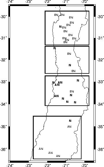
four regions, as indicated in Fig.1. It was determined that only the rainfall
anomalies during the final months of the rainy season (JulyŁAugust) have
a reasonable predictability using these models.
Predictions for JulyŁAugust 1995 proved to be partially
successful (see Fig. 1). Overall, the correct category was forecast in
13 cases out of 32; this is 2.3 cases better than chance expectation. Best
results were obtained in region 3 where forecasts indicated that the categories
normal (N) and above normal (AN) were the most probable. Forecast were
particularly bad in region 1, where the model mostly failed to anticipate
the mainly below normal (BN) observed conditions. In fact, the rainfall
deficit during the entire wet season worsened the already critical situation
derived from a four-year drought in this region. The model also failed
to anticipate the anomalously wet conditions observed in region 4, for
which a precipitation in the range of below normal Ł normal was predicted.
One reason for the failure in regions 1, 2 and 4 probably has to do with
the lack of association between SST and rainfall when near normal conditions
prevail in the equatorial Pacific, as explained next.
Figure 2 shows scatter diagrams of simultaneous average
values of rainfall in each of the four regions described in Fig. 1 and
SST anomalies in the NiZo 3 area during MayŁAugust of 1946Ł92. Most of
the circulation anomalies associated with warm or cold episodes in the
central Pacific are driven by teleconnection patterns concurrent with those
SST anomaly fields. Hence, the results in Fig. 2 can be used to assess
the upper limit of seasonal rainfall predictability in central Chile, when
SST data are used as a predicting tool.
Figure 2 indicates that reliable forecasts of NiZo 3 SST
anomalies could be useful in certain cases to anticipate rainfall anomalies
in central Chile. Specifically, cold episodes characterized by SST anomalies
lower than Ł0.5EC are mostly associated with below average rainfall in
all regions. Thus, a forecast calling for these cold conditions could be
used to anticipate below normal or normal winter rainfall in central Chile.
On the other hand, the existence of a reliable forecast indicating SST
anomalies greater than +1.0EC could be associated with above normal rainfall
in regions 1, 2 and 3, and with normal or above normal precipitation in
region 4.
Figure 2 also indicates that rainfall predictability based
on predicted SST anomalies in region NiZo 3 is considerably low when near
normal SST is anticipated. This is particularly the case for the present
year, as suggested by the currently predicted evolution of SST in the central
Pacific by various dynamic and statistical models (Experimental LongŁLead
Forecast Bulletin, March 1996 as well as the present issue).
Consistent with this lack of predictability, CCA rainfall
forecasts for JulyŁAugust indicate near normal or below normal precipitation
in all 4 central Chilean regions shown in Fig. 1, although the associated
probabilities of success are quite low and mostly statistically non-significant.
Specifically, both extended and nonŁextended models call for below normal
rainfall in regions 1 and 2. The probabilities of success of these forecasts,
based on the functioning of the models during the period 1947Ł91, are around
20% for region 1 and 30% for region 2, which are well under the threshold
of statistical significance. In regions 3 and 4, extended models anticipate
below normal precipitation, with an associated probability of 46% in both
cases. NonŁextended models suggest instead that normal conditions will
prevail in these two regions, with associated probabilities of 55% in region
2 and 44% in region 4. It should be noted that the only forecast with an
associated probability reaching the 95% significance level is that for
region 3, using the nonŁextended model.
References
Barnett, T. P. and R. Preisendorfer 1987: Origins and
levels of monthly and seasonal forecast skill for United States surface
air temperatures determined by canonical correlation analysis. Mon.
Wea. Rev., 115, 1825Ł1850.
Montecinos, A., and P. Aceituno, 1995a: CCA forecast of
rainfall in the subtropical west coast of South America (central Chile)
for JulyŁAugust 1995. Experimental LongŁLead Forecast Bulletin,
4(2), 17Ł19.
Montecinos, A., and P. Aceituno, 1995b: Pronostico estacional
de la precipitacion en Chile central. Direccion General de Aguas. Ministerio
de Obras Publicas, 39 pp + Anexos I, II.
Rutllant, J. and H. Fuenzalida, 1991: Synoptic aspects
of the central Chile rainfall variability associated with the Southern
Oscillation, Int. J. Climatol., 11, 64Ł76.
Fig. 1. Rainfall categories observed during JulyŁAugust
1995: AN, above normal; N, normal; BN, below normal. CCA forecasts predicted
the occurrence of categories N or AN in regions 1, 2 and 3; and N or BN
in region 4. Correct forecasts are indicated in bold.
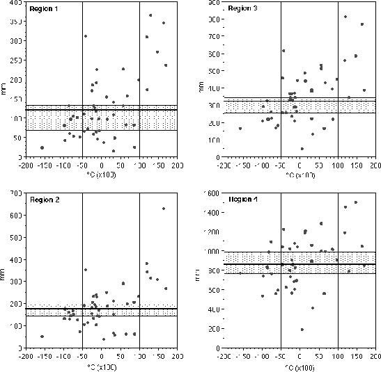
Fig. 2. Scatter diagrams of NiZo 3 SST anomalies
and spatially averaged rainfall in each of the regions indicated in Fig.
1, for MayŁAugust of 1946Ł92. Stippled bands indicate normal conditions
(N) and bold lines indicate the average rainfall in each region.