[Previous Article] [Next Article]
Merged Forecasts of Drought Index Anomalies along the Gulf Coast
in the U.S. Using Multiple Precursors, with a Kalman Filter
contributed by Zhongjian Liu1, Juan Valdés2 and Dara Entekhabi3
1Department of Civil Engineering, Texas A&M University, College Station, Texas
2Dept. of Civil Engineering and Climate System Research Program, Texas A&M University, College Station, TX
3Ralph M. Parsons Laboratory, Massachusetts Institute of Technology, Cambridge,
Massachusetts
An ENSO-based regional long-term operational hydrologic forecast system is described, and the
forecast skills for the extratropical drought index anomalies along the Gulf Coast in the U.S. are
shown. The skills are found to be useful for operational long-range forecasts. The above target
region is one of the 19 key regions persistently influenced by ENSO as revealed by Ropelewski
and Halpert (1987, 1996).
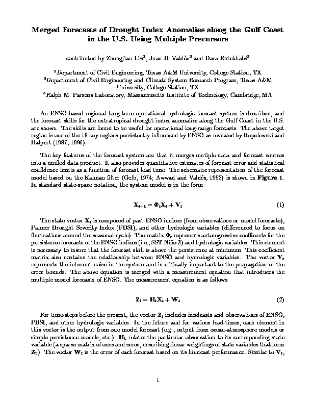
The key features of the forecast system are that it merges mutiple data and forecast sources into a
unified data product. It also provides quantitative estimates of forecast error and statistical
confidence limits as a function of forecast lead time. The schematic representation of the forecast
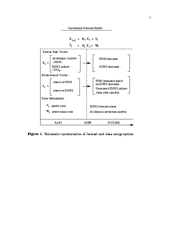
model based on the Kalman filter (Gelb, 1974; Awwad and Valdés, 1992) is shown in Fig. 1. In
standard state-space notation, the system model is in the form
Xt+1 = tXt + Vt(1)
The state vector Xt is composed of past ENSO indices (from observations or model forecasts),
Palmer Drought Severity Index (PDSI), and other hydrologic variables (differenced to focus on
fluctuations around the seasonal cycle). The matrix t represents autoregressive coefficients for the
persistence forecasts of the ENSO indices (i.e., the SST in Niño 3) and hydrologic variables. This
element is necessary to ensure that the forecast skill equals the skill of persistence, at minimum.
This coefficient matrix also contains the relationship between ENSO and the hydrologic variables.
The vector Vt represents the inherent noise in the system and is critically important to the
propagation of the error bounds. The above equation is merged with a measurement equation that
introduces the multiple model forecasts of ENSO. The measurement equation is as follows:
Zt = HtXt + Wt (2)
For time-steps before the present, the vector Zt includes hindcasts and observations of ENSO, PDSI, and other hydrologic variables. In the future and for various lead-times, each element in this vector is the output from one model forecast (e.g., from ocean- atmosphere models, simple persistence models, etc.). Ht relates the particular observation to its corresponding state variable (a sparse matrix of ones and zeros, describing linear weightings of state variables that form Zt). The vector Wt is the error of each forecast based on its hindcast performance. Similar to Vt, this information is critically important to propagating the errors of estimation and establishing confidence limits for the forecasts. The two equations now may be combined to yield a consistent and statistically optimal (optimal in the sense that the squared-deviations are minimized). The merged forecast of the mean state of the system is the updated vector Xt|t, where
Xt|t = t|t(HtT Rt-1Zt + -1t|t-1X-1t|t-1). (3)
The matrix t|t is the latest estimate of the covariance of the system states, and the matrix Rt is the
covariance associated with various observations and model forecasts of the system states. The
best estimate of the covariance matrix itself is produced by
t|t = (HtT Rt-1Ht + -1t|t-1)-1. (4)
The operational hydrologic forecasting system in this study uses multiple forecasts of ENSO to
produce forecasts of seasonal hydrologic variables. This is essentially a combined data fusion and
forecasting system that incorporates: 1) forecasted ENSO; 2) persistence-based forecasts; and 3)
up-to-date observ-ations. The system assimilates past observations, and hindcasts. It projects both
multiple model outputs and persistence into its merged forecast. The error bounds on the forecast
are also propagated. The chief characteristics of this system are: 1) multiple ENSO forecasts are
integrated into one hydrometeorological forecast, 2) each ENSO forecast is weighted according
to its error covariance structure as a function of lead-time, and 3) both ENSO and seasonal
hydrologic forecasts are used to update the underlying persistence (markovian) stochastic process.
The system provides products such as seasonal-to-interannual hydrometeor-ological forecasts. We
present estimates of forecast skill and accuracy for two cases: when ENSO precursors are
incorporated and when only hydrologic persistence is used. In this respect we provide quantitative
estimates of the impact of including precursor variables from multiple sources in
hydrometeorological long-range forecasting.
The extratropical drought index (PDSI) anomalies along the Gulf region are used as an example
to illustrate the above forecast system. The anomalous seasonal PDSI is aggregated from the
monthly PDSI (1895-1996, from NCDC, NOAA) in Texas and Louisiana along the Gulf Coast.
The ENSO-PDSI relationships in this region were studied by Piechota and Dracup (1996). Larger
area-averaging improves the signal-to-noise ratio and forecast potential, but the proposed forecast
model also can conveniently handle small region or station data. To reduce intraseasonal noise,
three-month seasons (i.e. DJF-MAM-JJA-SON) were used. The Kalman filter was run with two
scenarios: one, a pure hydrological model (first-order Markov model in this case) that does not
incorporate ENSO; the second, a hydrological model that incorporates ENSO. The climate state
up to the present is described using the observed GISST (Parker et al., 1994) Niño 3 monthly
data. Measurement errors of Niño 3 SST are provided by Reynolds (personal communication,
1996). Then, in the period to be forecast, ENSO forecasts and errors are used. These come from
the Lamont-Doherty Earth Observatory (LDEO) model (Cane et al., 1986; Zebiak and Cane,
1987), from its improved model (LDEO2; Chen et al., 1995), as well as other ENSO models.
Data sets from 1895-1972 were used to calibrate our model and estimate model coefficients of the
t matrix. The 1973-1996 validation period data sets were chosen as independent data to test
forecast skill. In the forecast period 1973-1996, in the case of the independent PDSI data, we are
not using any future information in our model forecasts. This case is referred to as persistence
forecasts. We also produce forecasts of PDSI incorporating observed and forecast ENSO, which
are referred to as ENSO-based forecasts. In this case, persistence is also merged in proportion to
its error covariance. The forecast root mean squared error (RMSE) in the period 1973-1996 is
shown as a function of forecast lead-time in Fig. 2. The forecast skills are summarized in Table 1.
Table 1. Forecast skill of the hydrometeorological forecast system for standardized PDSI
(dimensionless) for the 1973-96 verification period. The hit rate is with respect to five categories;
chance hit rate is 0.2.
Verification -----Number Of Seasons Lead-----
Criterion 1 2 3 4
RMSE .56 .75 .84 .88
Correlation .82 .77 .67 .55
Hit Rate .40 .38 .35 .34
The forecast skills of the model were examined further in terms of hit rates in a five-category
(quint) system (Q1=very dry, Q5=very wet). The categorical hit/miss tables (not shown) indicate
reasonable symmetry and an absence of any "odd" behavior. The hydrometeorological forecast
system shows that regional long-range prediction can significantly benefit from the use of
precursor information. We present a framework through which multiple precursor forecasts (i.e.,
ENSO) may be integrated (fused) together in inverse proportion to their errors (quantified by
hindcast covariances). The resulting hydrometeor-ological forecast product has quantitative
confidence limits associated with them as well.
The model's current forecast of the PDSI anomalies (in terms of Quintile 1 through 5) in the Gulf
coast region through 1997 are:
DJF Q2 (somewhat dry)
MAM Q3 (near normal)
JJA Q3 (near normal)
SON Q3 (near normal)
DJF Q3 (near normal)
Generally near normal conditions are expected throughout most of 1997 and for winter
1997-98.
Acknowledgments: We are grateful to R.W. Reynolds, M. Ji, S. Zebiak, M.A. Cane, R. Kleeman,
and B.P. Kirtman for providing SST observation error data and model forecast data. The second
author was partly supported by NASA grant NAGW-2427.
Awwad, H.M and J.B. Valdés, 1992: Adaptive parameter estimation for multisite hydrologic
forecasting. J. Hydra. Eng., 118, 1201-1221.
Cane, M., S.E. Zebiak and S.C. Dolan, 1986: Experimental forecasts of El Niño. Nature, 321,
827-832.
Chen, D., S.E. Zebiak, A.J. Busalacchi and M.A. Cane, 1995: An improved procedure for El Niño
forecasting: implications for predictability. Science, 269, 1699-1702.
Gelb, A., 1974: Applied Optimal Estimation. The M.I.T. Press, pp. 374.
Parker, D.E., P.D., Jones, C.K., Folland, and A., Bevan, 1994: Interdecadal changes of surface
temperature since the late nineteenth century. J. Geophys. Res., 99, 14373-14399.
Piechota, T.C., and J.A. Dracup, 1996: Drought and regional hydrologic variation in the United
States: Associations with the El Niño-Southern Oscillation. Water Resour. Res., 32(5),
1359-1373.
Ropelewski, C.F., and M.S. Halpert, 1987: Global and regional scale precipitation patterns
associated with the El Niño/Southern Oscillation. Mon. Wea. Rev., 115, 1606-1626.
Ropelewski, C.F., and M.S. Halpert, 1996: Quantifying Southern Oscillation-precipitation
relationships. J. Climate, 9, 1043-1059.
Zebiak, S.E., and M.A. Cane, 1987: A model of El Niño-Southern Oscillation. Mon. Wea. Rev.,
115, 2262-2278.
Fig. 1. Schematic representation of the forecast and data merge system.
Fig. 2. RMSEs normalized by the time series variance of forecasts of standardized PDSI along the
Gulf Coast in the U.S., shown for climatology (horizontal line with RMSE=1), the Kalman filter
model without ENSO incorporated (i.e. persistence model; line with circle), and the Kalman filter
model with the ENSO model (line with diamond). The forecast SST Niño 3 index is from LDEO2
starting from 1973. The RMSE (forecast error) is reduced when ENSO is included in the PDSI
forecast.