The 1994 Sahelian Rainy Season--
The Wettest Since 1964
The 1994 rainy season was the wettest since 1964 across the Sahel, based on
preliminary May through September data (Fig. 1).
Using the 1951-80 period as the baseline "normal," 1994 is only the second
year since 1967 to record above-normal rainfall for the season. Although the
heavy rains brought damaging floods to many areas, the longer-term impacts are
primarily beneficial, with water supplies ample and agricultural prospects
among the best in years.
The ITD
One factor contributing to abundant rainfall during 1994 was the northward
displacement of the Intertropical Discontinuity (ITD), which marks the northern
boundary of maritime air. This year's migration of the ITD, which is generally
equivalent to the ITCZ, is shown in Figure 2.
Northward anomalies equate to enhanced rainfall in the Sahel. Through June, its
northward advance (solid line) was close to the 15-year (1979-93) normal
(dashed line), but from July into October, the humid air was north of normal.
As a consequence, much of the Sahel and the southern Sahara Desert saw the
heaviest rains in years.
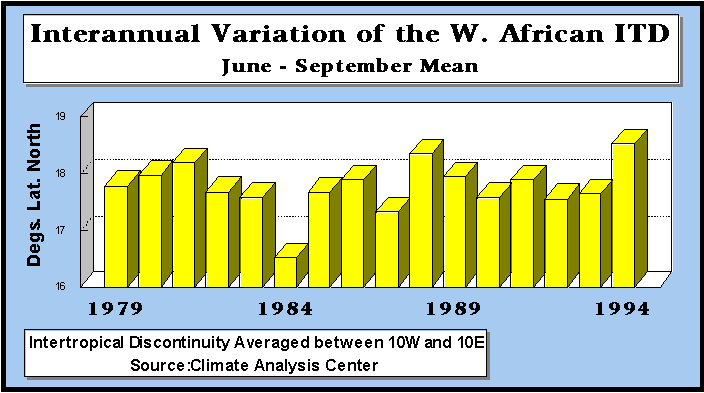
The June-September average latitude of the ITD correlates historically with
both rainfall and agricultural production in the Sahel region of Africa.
Figure 3 shows that the 1994 ITD latitude was the
highest across West Africa since records began in 1979.
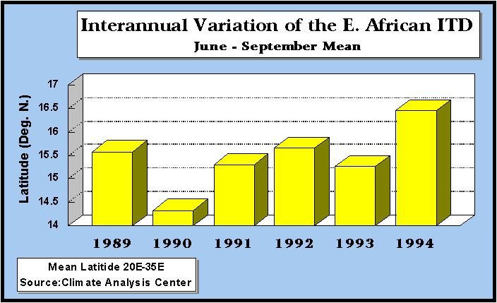
Data across eastern Africa is more limited, but also shows that the conditions
were favorable for heavy rainfall in East Africa during 1994, including Sudan,
Ethiopia, and Eritrea. Figure 4 indicates that the
ITD east of 20řE was the farthest north of the last six seasons.
Rainfall Totals
The total rainfall and percent of normal rainfall maps for the season
(Fig. 5) illustrate the large areal extent of the
heavy rains across Africa, with cumulative totals exceeding 120 percent (%) of
the 1961-90 mean across large sections of Senegal, Mauritania, and Mali, as
well as most of Niger's crop area, southwestern Chad, northern Sudan, and
eastern Ethiopia. Over 1000 mm fell on the Ethiopian highlands and most areas
from 11řN southward to the Equator, except from central and western Burkina
Faso southward across central and eastern Cote d'Ivoire and western and
southern Ghana.
Damage frequently resulted from heavy rains and was especially pronounced in
Sudan, Ethiopia, and Niger, according to press reports. In August, the Niger
River Basin Authority reported that the Niger River contained its highest
volume since 1950. During the five-month period in Niger alone, more than
three dozen individuals were killed by flooding, over 127, 000 people were
rendered homeless, and approximately 3000 sq. km. of crops were destroyed,
according to government officials appealing for international aid.
There were few areas with below-normal rainfall. The most significant dryness
stretched along the Gulf of Guinea coast from Cote d'Ivoire eastward to the
immediate coast of Togo and Benin. Less than 80% of normal seasonal rains fell
from extreme eastern Liberia eastward across central and southern sections of
Cote d'Ivoire, Ghana, Togo, and Benin and only about half of normal was
measured along the extreme southern tier of Cote d'Ivoire.
Monthly Highlights
The season began with fears of a developing famine across East Africa, with
weather problems only one among other contributing factors. Below-normal
rainfall during May ensured a poor minor season ("belg") crop for much of
Ethiopia. There were also food supply concerns in Kenya, Sudan, Somalia,
and Eritrea due to earlier poor harvests.
June brought near or above normal rains to much of the Sahel as most areas
south of 12řN recorded over 200 mm of rain, with the exception of the Gulf of
Guinea coastline from extreme eastern Guinea eastward to Benin. Less than half
of normal rain fell on these areas, as well as parts of Chad and the Ethiopian
lowlands. Other areas, however, received ample rainfall, with well
above-normal amounts in northern Nigeria and central and southern Sudan.
Plentiful rains also alleviated food shortage concerns in Somalia and Kenya.
In July, the main rainy season got under way in Ethiopia, but its delay in some
central and eastern areas posed a potential problem for the autumn harvests.
When the rains arrived, however, they were impressive. Media reports indicated
that flooding forced 60,000 people from their homes near the Red Sea in
Ethiopia and Djibouti. Farther west, abundant rains fell on much of the Sahel
and sub-Saharan Africa, with significant showers reaching exceptionally far
north (past 20řN) in both Mali and Sudan. Well above-normal July rains also
soaked southeastern Niger and parts of central and northern Chad. Farther
south, less than 25 mm fell on most areas from eastern Liberia to southwestern
Ghana.
August was also unusually wet, with heavy rains (100-400 mm) drenching most
areas from Senegal and southern Mali eastward to western Sudan as well as
central and northwestern Ethiopia, northern Cameroon, and northwestern Zaire.
Totals were well above normal (>150%) in a swath from north-central
Mauritania southeastward to central Chad. Flooding marooned 30,000 people in
the Ethiopian highlands early in the month, according to press reports.
Flooding even swept into some of the drought-affected areas of southern
Ethiopia during the last half of August, destroying lives and property, and
reportedly left 30,000 people homeless in Niger.
The widespread wetness continued through September, with exceptionally heavy
rains (100-400 mm) falling from central Senegal southward through Liberia and
eastward to central Ethiopia. Convective complexes continued to track unusually
far north into typically dry areas of Mali and Niger.
October saw drier conditions finally beginning to cover the Sahel, but
occasional heavy rains still fell unseasonably far north, with new October
records established in southeastern Mauritania. Flood reports continued,
including one event near Khartoum, Sudan. Farther south, above-normal rains
erased lingering dryness in Cote d'Ivoire and along the Guinea coast.
Impacts
Despite localized crop damage from excessive rainfall and flooding, production
prospects for the crops currently being harvested are mainly favorable. There
are some areas of concern because of either a late start to the rainy season
(Senegal's northern groundnut basin, eastern Ethiopian crop areas) or dry
periods within the growing season (central and southwestern Burkina Faso,
western Mali, western Niger south of the Mali border), but the abundant
moisture in most areas should lead to a positive outcome across the region from
Mauritania eastward to Sudan and Eritrea.
Contributing Factors
The anomalous northward extension of the ITD during 1994 was a major factor
contributing to the wet conditions across the Sahel/Sudan zones of Africa and
the dryness farther south along the Gulf of Guinea coast. African tropical
waves tend to be more active in the Sahel when the ITD is farther north, and
the squall lines associated with the tropical waves are believed to be
responsible for about 80% of the total rainfall during the rainy season.
In 1994, the relatively high frequency of the waves and the associated squall
lines may have been associated with a well-established African Easterly Jet
(AEJ) at 700 mb and a strong Tropical Easterly Jet at 200 mb. The location
and intensity of the subtropical high pressure systems over the oceans
surrounding Africa, along with the location and intensity of anomalous sea
surface temperatures, also influence Sahelian precipitation. During the summer
of 1994, the subtropical high pressure systems tended to be north of normal,
both at the surface and aloft. This contributed to the hot summer in Europe
and likely to the northward extension of the rains in Africa. In addition,
during June and July, there were unusually low sea surface temperatures in the
Gulf of Guinea near the equator. Historical studies have shown a correlation
between cool water in this region and unusually wet seasons in the Sahel.
The effects of large-scale circulation features and sea surface temperatures on
the 1994 season are still being investigated.
Comments on the Long-term Outlook
There is no evidence that the 1994 season is the start of a trend toward the
wetter Sahelian climate of the 1950s and early 1960s
(Fig. 1). The long-term climate records of rainfall
, lake levels, and stream flow suggest that the extended period of dryness
which began in the late 1960s and has continued into the early 1990s should
eventually be followed by a period of increased rainfall in the Sahel, but
there is no reason to believe that this change is imminent. Though the outlook
for next year is also not known, there are a few indicators that raise some
hope for normal or better rainfall, at least compared with the past 25 years
or so. Research by Chris Landsea, Bill Gray, and John Knaff of Colorado State
University has shown that above-normal rainfall over the Gulf of Guinea
countries during the August-November period correlates with favorable rainfall
the following summer in the Sahel. The October-early November period is
especially significant. This year, so far, rainfall has been well
above-normal in the Gulf countries during October. Some other indicators, such
as stratospheric winds, also look favorable. Nevertheless, given the mixed
record of past attempts at seasonal forecasts for the Sahel region,
extrapolating this year's rainfall into the future would be very speculative.