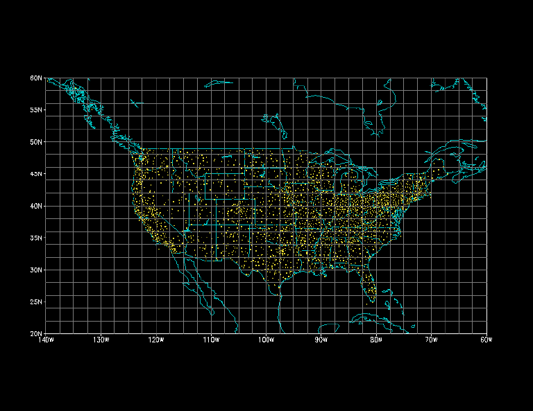
Figure 1. Typical station distribution for hourly reporting stations in January 1963. Gridlines represent the (33 x 21) grid to which the station data have been analyzed.
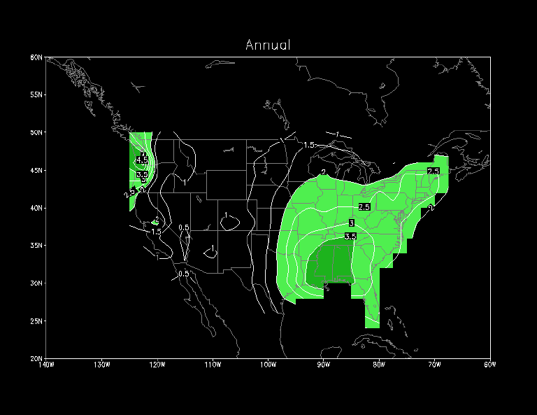
Figure 2. Mean (1963-1993) annual precipitation (units: mm/day). Light (dark) shading denotes regions with rates exceeding 2 mm/day (3.5 mm/day).
Figure 3. Mean (1963-1993) monthly precipitation (units: mm/ day) for individual months. Light (dark) shading denotes regions with rates exceeding 3 mm/day (5 mm/day).
Figure 4. Regions of the United States over which the averages are done in Fig. 5.
Figure 5. Five-day running mean (1963-1993) precipitation (units: mm/day) for selected regions in the United States.
Figure 6. Mean (1963-1993) annual frequency of hourly precipitation expressed as a percentage of the total number of hours in a year. Light (dark) shading denotes regions with frequencies exceeding 15% (20%).
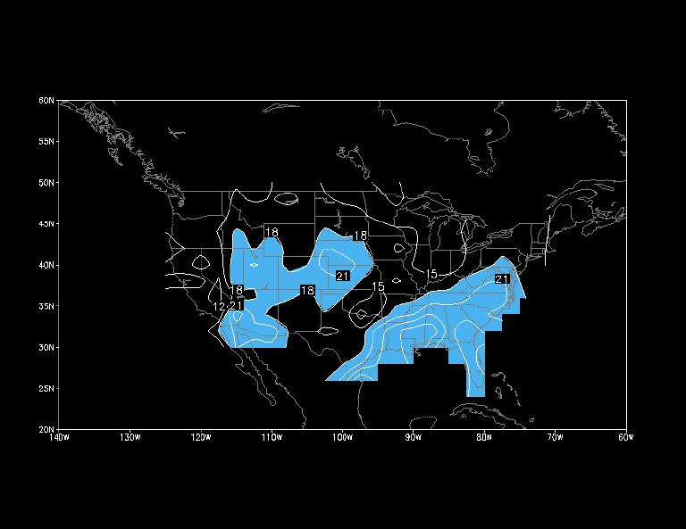
Figure 7. Mean (1963-1993) seasonal frequency of precipitation for daily mean rates greater than 1 mm/day expressed as a percentage of the total number of days in (a) DJF, (b) MAM, (c) JJA and (d) SON. The progressively darker shading denotes regions with percentages exceeding 30%, 40% and 50% respectively.
Figure 8. Same as Fig. 7 except greater than 5 mm/day. The progressively darker shading denotes regions with percentages exceeding 12%, 18% and 24% respectively.
Figure 9. Same as Fig. 7 except greater than 10 mm/day. The progressively darker shading denotes regions with percentages exceeding 6%, 10% and 14% respectively.
Figure 10. Same as Fig. 7 except greater than 25 mm/day. The progressively darker shading denotes regions with percentages exceeding 2%, 4% and 6% respectively.
Figure 11. Amount of the mean (1963-1993) seasonal precipitation resulting from daily mean rates greater than 1 mm/day expressed as a percentage of the mean seasonal precipitation for (a) DJF, (b) MAM, (c) JJA and (d) SON. Light (dark) shading denotes regions with percentages exceeding 90% (95%).
Figure 12. Same as Fig. 11 except greater than 5 mm/day. Light (dark) shading denotes regions with percentages exceeding 70% (80%).
Figure 13. Same as Fig. 11 except greater than 10 mm/day. Light (dark) shading denotes regions with percentages exceeding 60% (70%).
Figure 14. Same as Fig. 11 except greater than 25 mm/day. Light (dark) shading denotes regions with percentages exceeding 20% (30%).
Figure 15. Standard deviation of the daily mean (1963-1993) precipitation (units: mm/day) for (a) DJF, (b) MAM, (c) JJA and (d) SON. Light (dark) shading denotes regions with values exceeding 4 mm/day (8 mm/day).
Figure 16. Standard deviation of bandpass (2.5-6 day periods) filtered daily mean (1963- 1993) precipitation anomalies (seasonal cycle removed). Light (dark) shading denotes regions with values exceeding 3 mm/day (5 mm/day).
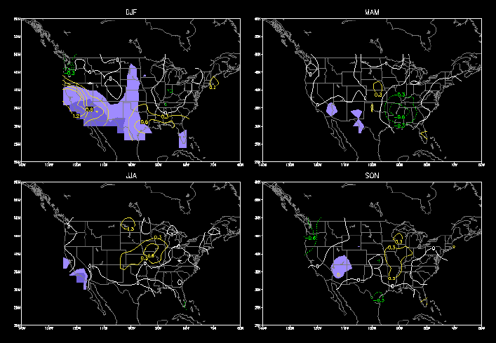
Figure 17. Same as Fig. 16 except for lowpass (greater than 10 day periods) filtered anomalies.
Figure 18. Mean (1963-1993) seasonal skew of the daily mean precipitation for (a) DJF, (b) MAM, (c) JJA and (d) SON. The contour interval is geometric (0, 1, 2, 4, 8,..). Light (dark) shading denotes regions with values exceeding 4 (8).
Figure 19. Mean (1963-1993) seasonal median of the daily mean precipitation (units: mm /day) for the subcategory of days in which measurable precipitation occurs for (a) DJF, (b) MAM, (c) JJA and (d) SON. Light (dark) shading denotes regions with rates exceeding 4 mm/day (6 mm/day).
Figure 20. Normalized amplitude and phase of the diurnal cycle in the total frequency of precipitation during the 1963-1993 period for June-August (top) and November- March (bottom). The direction of the vectors indicates the preferred time of occurrence. The length of the vectors depicts the amplitude in percent (note phase and amplitude legends in lower right of each figure). Since the amplitudes are normalized by the 24-h mean frequency, the normalized amplitudes can exceed 100% in regions where precipitation is strongly suppressed during half of the day (Wallace 1975).
Figure 21. Percentage of total daily precipitation amount for JJA that is contributed by precipitation that occurs in the 3-hour period centered on the preferred time of occurrence as determined from harmonic analysis (Fig. 20).
Figure 22. Mean (1963-1993) seasonal precipitation difference between night (0000 GMT to 1200 GMT accumulation) and day (1200 GMT to 0000 GMT accumulation) expressed as a percentage of the mean daily precipitation rate. The two darker (lighter) shades denote regions with percentages greater than 5% and 15% (less than -5% and -15%) respectively.
Figure 23. Same as Figure 22, except for mean seasonal differences in excess of 10 mm /day. Dark (light) shading denotes regions with percentages greater than 5% (less than -5%).
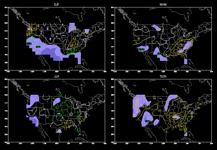
Figure 24. Warm event composite difference from normal (1963-1993) seasonal precipitation. Units are mm/day, with solid (dotted) lines denoting positive (negative) anomalies. Shaded regions indicate where anomalies are greater than 25% of the mean.
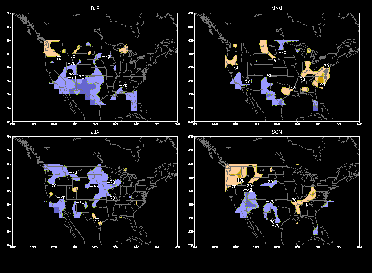
Figure 25. Percentage of warm event years (8) in which anomalies of more than 10% of the mean were observed. Solid (dotted) lines indicate the percentage of cases that positive (negative) anomalies were observed.
Figure 26. Same as Figure 24, except for cold event composites.
Figure 27. Same as Figure 25, except for cold event composites.