1. Introduction
-
Historical observations of hourly precipitation amount are extremely
useful tools for diagnostic and research purposes. In the United
States, such observations are routinely made at a number of sites,
the most common being from the several hundred National Weather
Service (NWS) stations around the country and by the thousands
of cooperative observers. Unfortunately, hourly data are quite
voluminous which can make it difficult to use.
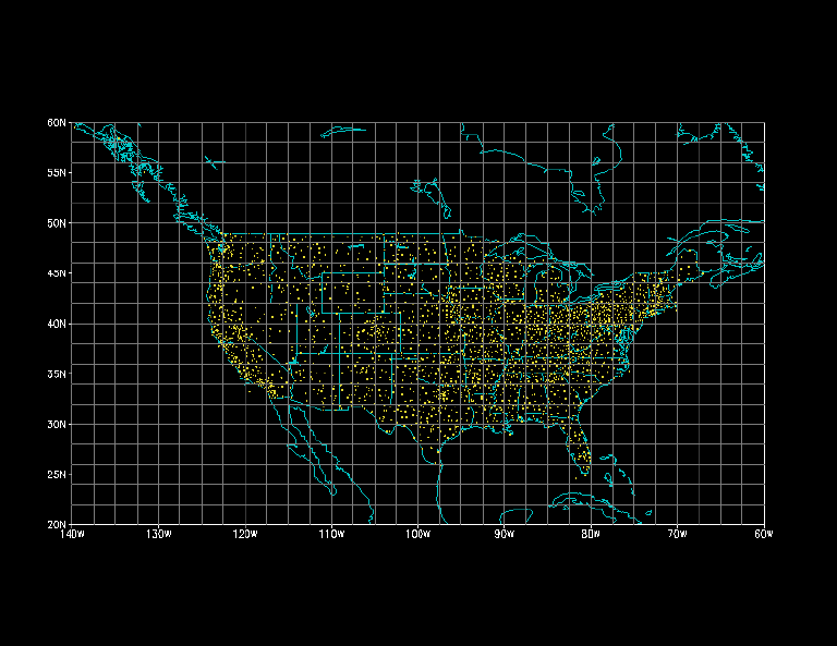
In this atlas we describe a set of hourly, gridded precipitation analyses over the conterminous United States obtained using data from the NWS/Techniques Development Laboratory, who compiled and quality-controlled station data archived at the NOAA National Climatic Data Center. The time domain covers the period 1 January 1963 through 31 December 1993. To make a useful and manageable set of analyses from 31 years of hourly observations for approximately 2,500 stations, we gridded the hourly analyses into 2° latitude by 2.5° longitude boxes (Fig. 1) using a Cressman (1959) scheme with modifications (Glahn et al. 1985; Charba et al. 1992). This effort reduced the volume of data from roughly 20 Gbytes to 0.75 Gbytes. The domain for the gridded data is (140° W - 60° W, 20° N - 60° N).
We present analyses of the diurnal, daily, monthly-seasonal and interannual variations in precipitation in the United States to demonstrate the utility of this data set. Studies of precipitation variations are too numerous to cite here , and the results should not be viewed as comprehensive.
2. Data sets and data access
-
The gridded hourly precipitation data set is available from the
Climate Prediction Center at the National Centers for Environmental
Prediction. Information
about data access can be obtained by contacting the authors at
-
Climate Prediction Center, W/NP52
Attn: Hourly Gridded Precipitation
NOAA/NWS/NCEP
NOAA Science Center, Room 605
5200 Auth Road
Camp Springs, MD 20746
-
dset hprec.Y1963
title CPC Hourly Precipitation for the United States (1963)
options sequential big_endian
undef 9999.
xdef 33 linear -140.000 2.500
ydef 21 linear 20.000 2.000
zdef 1 linear 1 1
tdef 8760 linear 01Z01jan63 1hr
vars 1
PREACC 0 0 Accumulated Hourly Precipitation (inches)
endvars
- 2.2 Missing Data
An inventory of all gaps in the data set for the period (1963-1993) is given in the Appendix. These represent periods for which no data were available or for which an insufficient number of observations were available to perform an analysis. For the 31 year period (1963-1993) analyses are available 99.7% of the time (the total number of missing hourly analyses is 904). For convenience, the missing value (9999.) has been inserted at all gridpoints when an analysis is unavailable. Occasionally, no precipitation is observed over the entire U.S. At these times the analyzed grid contains zeros. These times should not be confused with those when an analysis was not performed.
For many of the years, missing values appear for the hours 01Z through 06Z on January 1st only. The reason for this peculiarity is that the analysis program uses an asymmetric window in time and requires that the observations for the previous two hours be available relative to the hour being processed. For many of the years the first several hours of data are missing due to upstream data processing problems in handling a change of year combined with the 5 hour time differential between Greenwich Mean Time and Eastern Standard Time.
- 2.3 Observations
About one-third of the stations analyzed are first order NWS stations and the remaining ones are climatic substations (observations from cooperative observers). The precipitation gauges used at the climatic substations are of either the Universal or Fisher/Porter type. Precipitation amounts from the Fisher/Porter gauges (which are used at slightly less than half of the stations) are accurate only to the nearest one-tenth of an inch. The accuracy of the Universal gauges is one-hundredth of an inch.
Users of the data may also notice occasional "bulls eyes" along the southeast coast of Alaska. This is due to the fact that two Alaskan stations (lat,lon)=(131.57° W, 55.03° N) and (139.67° W, 59.52° N) with relatively high separation distance were inadvertently analyzed. Also, since the data were subjected to objective analysis, precipitation amounts have been interpolated to grids for which no gauge observations exist. This is readily seen over the oceanic parts of the domain. We recommend using the analyzed data only at gridpoints over the conterminous U.S.
For the discussion of daily mean statistics in section 4, measurable precipitation is defined as more than 1.0 mm day-1. A relatively high threshold for measurable precipitation is used com pared to studies based exclusively on station data (e.g. Barnston 1993) because the observations have been analyzed at a coarser res olution than the average station spacing (roughly 70 km) which can lead to an overabundance of trace amounts. A trace is defined as nonzero, but less than a measurable amount of precipitation. Bec ause the observations are available only over land, a mask (availa ble with the data set) is used over the oceans. Finally, througho ut the atlas the term "rainfall" is equivalent to measurable preci pitation.
- 2.3 Observations
or through e-mail to Wayne Higgins at wd52wh@sgi85.wwb.noaa.gov.
An electronic version of this atlas is found in the Climate Prediction Center Home Page under
Research Papers: NCEP/CPC Atlas Archive
; after mid 1996 the CPC Home Page address may become http://ncep.wwb.noaa.gov.
2.1 Format
The files are organized to allow them to be easily read and displayed with the GrADS graphics and display program (see theGrADS Home Page at http://grads.iges.org/grads/head.html for more information) which was developed at the Center for Ocean-Land-Atmosphere (COLA). The data representation is IEEE 32 bit floating point and the record blocking is FORTRAN block control words (in an assign the data sets have ieee f77 format). The data sets are stored in one year segments and a data descriptor file ("control file") is available for each year. The "control file" contains all information necessary to READ a given data set (i.e. specific information about the resolution, the domain, the date and time stamp, etc.) and may be used for GrADS viewing if desired. Thus, prior to accessing a given data set, the user should study the associated "control file". The following is an example of a "control file" for hourly precipitation from 1963:
In this example the first three lines are relevant only for users of GrADS; they specify the data set name, the title and the data format. We note that the hourly precipitation data set was created in a UNIX environment on a "big endian" machine. Next, the undefined, or missing, value 9999. is given. There are 33 points in the x-direction (i.e. longitude) with the first point at 140° W and with a grid spacing of 2.5°. There are 21 grid points in the y-direction (i.e. latitude) with the first grid point at 20° N and with a grid spacing of 2.0°. There is a single level in the vertical. There are 8760 records in this file (1 record per hour) starting at 01Z on January 1, 1963. There is 1 variable in this data set, namely the hourly accumulated precipitation (PREACC) with units of inches. The hour assigned to a precipitation amount is that which begins the hourly period. For example, an amount for 00Z represents an accumulation over the period 00Z-01Z, an amount for 01Z is for the period 01Z-02Z, etc. We note that in this atlas the data has been converted to metric units and expressed as a rate (i.e. m m/day).
3. Monthly and seasonal time scale variability
-
3.1. Amount
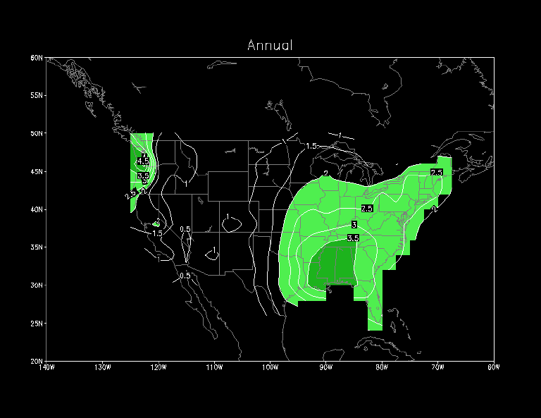
In an annual mean sense, the wettest parts of the country are the Pacific Northwest and the central Gulf Coast states (Fig. 2). The seasonal cycle of monthly mean precipitation over the U. S. ( Fig.3) shows that the centers of maximum rainfall are in the Northwest and Southeast during the cool season (November-March), and over the Southeast during the warm season (April-October). During the cool season the regions of maximum rainfall are strongly affected by winter cyclones. During spring the Pacific Northwest rainfall decreases but the Gulf Coast region continues to have high amounts due to the increasing role of convective activity. Also, during spring, the maximum along the Gulf Coast shifts slowly westward towards Arkansas and Oklahoma where severe convective storms occur at the interfaces between cool dry Canadian air and warm moist air from the Gulf of Mexico. During the early summer months this maximum expands northward towards the upper midwest. A new maximum also appears along the eastern Gulf Coast where sea-breeze convergence leads to frequent afternoon and evening thunderstorms. Summer precipitation in the west is very light. Throughout the year the lowest amounts occur in the Rockies, the High Plains, the Great Basin and the Desert Southwest. Comparisons of the 5-day running mean precipitation for selected regions (Fig. 4) in the United States show considerable difference among these regions (Fig. 5); grid boxes over water are not included in the averages. For instance, the rainfall distribution in the Pacific Northwest is out of phase with that in the Midwest and the Great Plains states, while the Rocky Mountain and Northeast regions have little seasonal variation. Although the Pacific Northwest has a pronounced dry season, that region experiences the highest mean annual rainfall because the most intense precipitation rates (more than 5 mm/day) are observed there during the cool season.
3.2. Frequency
The pattern of mean annual frequency (Fig. 6) of hourly precipitation (expressed as a percentage of the total number of hours in a year) is very similar to the pattern of mean annual precipitation amount. The frequency of occurrence is highest in the Pacific Northwest despite the pronounced dry season there during the summer months (Fig. 5). Frequencies of occurrence range from 15-20% over most of the country east of the Mississippi, both on an annual basis and during the cool and warms seasons individually (not shown).
4. Daily variations
-
This section contains some statistics on the variability of daily mean precipitation for the period 1963-1993. Maps of the mean seasonal frequency of precipitation for various thresholds (section 4.1) and the fraction of mean seasonal precipitation exceeding threshold rates (section 4.2) are the primary means by which the variability is expressed. In both subsections maps are shown for (a) measurable precipitation (at least 1 mm/day), and for daily precipitation at rates greater than (b) 5 mm/day, (c) 10 mm/day and (d) 25 mm/day. Summary statistics (standard deviation, skew, median) are presented in section 4.3. Overall, these statistics are intended to provide a general idea of the range of possibilities for precipitation events, enabling diagnosticians and forecasters to appreciate the degree of abnormality of an observed event or forecast.
4.1. Frequency
In this subsection we examine the mean (1963-1993) seasonal frequency of precipitation for various threshold precipitation rates. The thresholds are defined in terms of daily mean rates (i.e. mm/day) and frequencies are expressed as a percentage of the total number of days in a season (i.e. DJF, MAM, JJA, SON).
Comparisons of the frequencies for measurable rainfall (Fig. 7) show the highest values (65% or more) over Florida during summer (JJA), consistent with the prevalence of showers and thunderstorms there, and the lowest values over the Desert Southwest. In winter (DJF) the frequency field has its highest values in the Pacific Northwest (60% or more) where Pacific cyclones occur. There are also relatively large values downwind of the Great Lakes (e.g. north central New York) where lake induced snow often persists for days after a winter storm and during cold air outbreaks. The patterns in spring and autumn are more similar to the winter pattern than the summer pattern and values tend to be a bit higher east of the Rockies in spring.
Peak frequencies for areal mean precipitation observations greater than 5 mm/day (Fig. 8) are seen in the Pacific Northwest (more than 40%) during winter; maxima in this region are also found during autumn and spring but with lower frequencies. Secondary maxima extend from the central Gulf States along the windward side of the southern Appalachians in winter and spring and, to a lesser extent, in autumn. In autumn there is a south Florida peak due to tropical storms and residual convective activity. The summer pattern shows the highest frequencies along the Gulf Coast from Louisiana to Florida with a secondary maximum over the upper midwest due mainly to mesoscale convective systems.
The mean seasonal patterns for rates greater than 10 mm/day (Fig. 9) are quite similar to those in Fig. 8though with lower frequencies. The highest values by far are found in the Pacific Northwest during September to May. Much of the western half of the country (with the exception of the coast) has percentages less than 2% throughout the year reflecting the lack of moisture laden storms. In summer the highest frequencies are again found along the Gulf coast and in autumn the peak values are found over the lower Mississippi Valley and south Florida.
For daily rainfall rates exceeding 25 mm/day (~1.0 inch/day), the peak frequencies are found near Portland Oregon (more than 9%) and over the central Gulf States (more than 4%) during winter (Fig. 10). A weaker maximum along the Pacific Northwest coast also occurs in autumn. In spring the peak frequencies are in the central Gulf Coast states and western Tennessee Valley (more than 4%). In the autumn the maximum is shifted further west into the lower Mississippi Valley. Surprisingly, there is a noticeable lack of peak values in the Southeast in summer apparently reflecting the lack of synoptic-scale systems to organize the "popcorn" convective activity into widespread "heavy" events. The Great Lakes, Northern Plains and much of the western half of the U.S. have frequencies of less than 1% throughout the year.
4.2. Amount exceeding threshold rates
In this subsection we examine the amount of the mean (1963-1993) seasonal precipitation resulting from precipitation rates exceeding various thresholds. As in subsection (4.1) the thresholds are defined in terms of daily mean rates (i.e. mm/day) and the amounts are expressed as a percentage of the mean seasonal precipitation.
Comparisons of the mean seasonal patterns for measurable rainfall (Fig. 11) show the highest values (95% or more) over the eastern half of the United States during all seasons of the year (except for the Upper Midwest and Northern Plains during winter). Along the west coast values exceed 95% in all seasons except summer, when little or no precipitation occurs in California.
The amounts for rates exceeding 5 mm/day (Fig. 12) shows peak values along the west coast exceeding 90% during winter and 80% in spring and autumn. Maxima also extend from the Gulf Coast States to the Tennessee Valley and eastward to the coast during autumn, winter and spring, reflecting the prevalence of synoptic-scale systems during these seasons. The summer pattern shows values exceeding 80% over the corn belt where mesoscale convective systems are common.
The mean seasonal patterns for rates exceeding 10 mm/day (Fig. 13) are quite similar to those in Fig. 12though percentages are lower. While the ratios exceed 80% in the Pacific Northwest during winter, values in the central Gulf Coast States and western Tennessee Valley remain relatively high (exceeding 70%) during autumn, winter and spring. The absence of moist systems over the Northern Plains is particularly apparent during winter. In summer the highest percentages are again found over the central Plains. Overall, these patterns appear quite similar to those of Fig. 9 in section 4.1.
For the highest rates of 25 mm/day (~1.0 inch/day) or more, the largest values are found in the Gulf Coast States (exceeding 40%) during autumn, winter and spring (Fig. 14). The maximum over southern California during winter is also notable. Values less than 10% are found over the Great Lakes and much of the western half of the U.S. throughout the year.
4.3. Standard deviation, skew and median
In this subsection we examine the seasonal standard deviation, skew and median of the daily mean (1963-1993) precipitation. As in the previous two subsections, these statistics are calculated using daily mean rates (mm/day). In addition, one should be aware that the standard deviation is affected by the underlying march of the annual cycle (which has not been removed in Fig. 15 but which has been removed in Figs. 16 and 17).
The standard deviation (Fig. 15) shows a very different pattern for the summer as compared to the other seasons. In autumn, winter and spring the highest values are found in the Pacific Northwest due to Pacific storms and over the central Gulf Coast states due to synoptic-scale systems. In summer the variability is small in these regions (especially the Pacific Northwest) due to the infrequency of precipitation events.
We also examined characteristics of the variability of daily mean rainfall on synoptic-scale and low-frequency timescales. Daily mean precipitation was detrended by removing the annual cycle (time mean, annual and semi-annual harmonics) from the daily data. Bandpass (2.5-6 day periods) and lowpass (greater than 10 day periods) filters of Blackmon and Lau (1980) were applied to the daily anomalies to isolate synoptic-scale (Fig. 16) and low-frequency (Fig. 17 ) variability. During autumn and winter we find that synoptic-scale variability dominates in the southeastern U.S. In these seasons low-frequency variability dominates the west coast reflecting the effects of blocks and cut-off lows in the eastern Pacific on the Pacific storm track. Variability in the spring and summer is more evenly split between the two frequency bands.
The skew is a measure of the departure of the shape of a distribution from symmetry. The frequency distribution will generally be skewed when there is a physical cut-off close to the observed range of the observations. In the case of rainfall, the frequency distribution is extremely skewed since rainfall cannot be negative and since the mode of rainfall is usually near (or at) zero. Over the United States, the skew of daily rainfall is typically highly positive since the mean is greater than the mode. It is well known that the strong positive skew associated with daily mean rainfall necessitates the use of gamma or log normal distributions to model precipitation statistically. The skew is computed as the third moment (the mean of the cubed deviations from the mean) divided by the cube of the standard deviation, that is
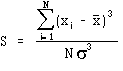
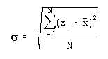
in which is the daily mean precipitation, is the mean seasonal precipitation, N is the total number of days, and is the standard deviation given by
The seasonal mean skew patterns (Fig. 18) show the highest values where rainfall rarely occurs (because of the high frequency of zero precipitation). This effect is most dramatic in southern California during summer and over the northern Plains in winter. The lowest values of skew occur where rainfall occurs most frequently, e.g. over the Pacific Northwest and the eastern U.S in autumn, winter and spring. Overall, the skew patterns correspond quite well to the frequency of precipitation patterns (e.g. Fig. 7). Skew is also sensitive to the extreme individual amounts which may explain the scattered "bulls-eyes" .
Because the percentage frequency of no measurable precipitation (defined here as either zero or amounts less than or equal to 1 mm/day) is the most frequently occurring category at many locations, the median is computed for the subcategory of days in which measurable precipitation occurs. In general, this field (Fig. 19) resembles the distributions in the previous two subsections for the highest precipitation rates. In winter, maxima exceeding 6 mm/day are found along the west coast (including southern California), the central Gulf Coast states, Tennessee Valley and eastern New England. A similar distribution occurs in autumn and spring, but with lower rates for the most part. Frequent convective activity in summer is associated with relatively high rates over the eastern half of the U.S., with the highest values over Iowa. Throughout the year wet day median amounts are low over the Rockies.
5. Diurnal Cycle
-
The results of a harmonic analysis on the 31-year mean hourly
data (Fig. 20) indicates the large differences in the diurnal
cycle of precipitation between the summer and cool seasons. The
summer season (June-August) is characterized by a late-afternoon
preference over the Rocky Mountains, a near-midnight preference
in the Plains, and a mid-afternoon preference over most of the
Southeast and mid-Atlantic states. During the cool season (November-March),
the amplitude of the diurnal cycle in precipitation is considerably
smaller and the phase is also quite different than is observed
during the summer season.
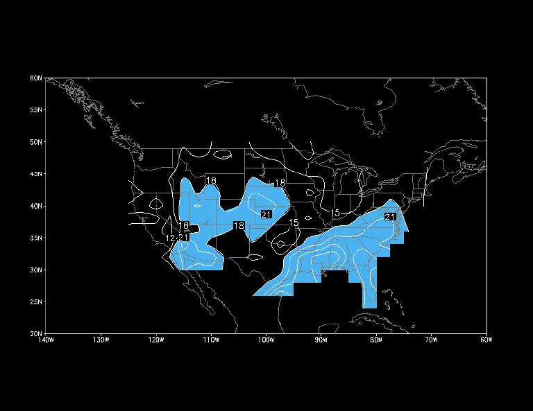
In the east and Rocky Mountain regions the preferred time for precipitation occurrence during the summer months is modulated by the surface heating induced rising motion during the warm season that triggers mid-late afternoon convective rainfall in those regions. In the Plains states, however, several studies have shown that the pronounced midnight maximum is associated with interactions with a low-level jet circulation that peaks in the late evening / early morning over the southern and central Plains states. The amount of rainfall for the 3 hour period centered on the hour of preferred time of occurrence is substantial, accounting for nearly 20% of mean daily totals in the west-central part of the country and over 20% in much of the South and East (Fig. 21). For comparison purposes, note that if the rainfall were equally distributed over the course of the day, then 12.5% of daily total rainfall would be expected over a 3-hour period.
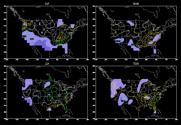
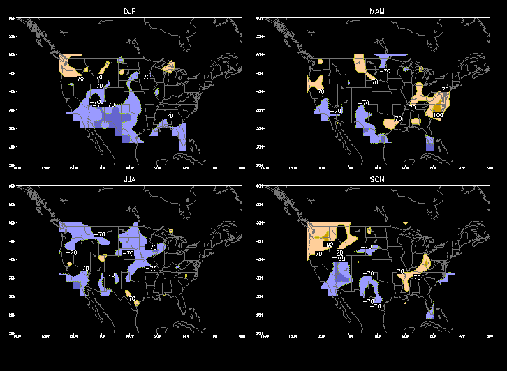
The seasonal difference in the diurnal cycle of precipitation is also quite evident by inspecting the seasonal mean daytime-nighttime precipitation differences (Fig. 22). Very little difference is observed during December-February (DJF). During March-May (MAM) in excess of 15% more rainfall falls during the nighttime hours (0000 GMT to 1200 GMT) than in the daytime hours (1200 GMT to 0000 GMT) over the southern Plains states with a commensurate decrease in precipitation over Florida. This pattern is amplified both in magnitude and spatial extent during JJA, when the nighttime rainfall exceeds daytime rainfall by more than 45% in western Nebraska, western Kansas and eastern Colorado. In much of the Southeast, daytime rainfall exceeds nighttime rainfall by more than 25%. Between the Plains states and the Southeast, much smaller differences between daytime and nighttime rainfall are observed in a narrow region from central Texas to the Great Lakes. This feature is consistent with the harmonic analysis results (Fig. 20). During September-November (SON), daytime rainfall is about 10%-15% higher in the Gulf Coastal states compared to nighttime. The distribution of night-day differences for precipitation events exceeding 10 mm/day is very similar to the pattern of mean night-day differences (Fig. 23).
6. Interannual Variations
- Research has shown that variations in seasonal precipitation in some parts of the U.S. are linked to the ENSO phenomenon (Ropelewski and Halpert, 1986). Here we examine this question with the use of this hourly precipitation data base in concert with the Southern Oscillation Index (SOI) data, which is a robust indicator of the state of ENSO. Five month running mean SOI data were used to identify seasons that experienced mature "cold" and "warm" episode conditions during the 1963-1993 period. The following seasons/ years were identified as periods during which mature warm/cold conditions were observed in the tropical Pacific:
-
Seasons with mature "warm" episode conditions Seasons with mature "cold" episode conditions DJF MAM JJA SON DJF MAM JJA SON 65-66 65 65 65 70-71 70 71 71 68-69 69 69 69 73-74 73 73 73 69-70 72 72 72 75-76 75 75 75 77-78 77 77 77 88-89 89 88 88 82-83 82,83 82 82 86-87 87 87 87 91-92 92 -- -- 92-93 93 93 93
(For DJF, the first year is the year of the December)
Identical comparisons were made with mature cold event composite precipitation (Fig. 26, Fig. 27), although caution must be used in the interpretation of the results, since only 4 "cold" events occurred during the 1963-1993 preiod. The most robust signal is during winter in the Southwest U.S. from eastern Arizona to west Texas where precipitation tends to be 25-50% below normal, which occurred in all 4 DJF seasons that experienced mature cold episode conditions. Below normal precipitation is also suggested during DJF in Florida and the southern portions of the surrounding Gulf Coast States. Above normal rainfall is suggested in the Mid-Atlantic states and the Pacific Northwest during MAM nad SON, respectively.
Acknowledgments
- We wish to thank Jess Charba of NOAA/Techniques Development La boratory for the hourly station data and Ying Lin of the NCEP/Environm ental Modeling Center for help in the initial processing. Thanks also go to Chester Ropelewski and Jae Schemm for useful comments which sub stantially improved this atlas. This work was partially supported by Interagency Agreement No. S-41367-F under the authority of NASA/GSFC a nd by the NOAA Office of Global Programs under the GEWEX Continental S cale International Project (GCIP).