HOME> Expert Assessments>Hazards Outlook
For 3-7 day hazards see Weather Prediction Center's: WPC 3-7 Day Hazards
U.S. Week-2 Hazards Outlook - Made May 09, 2024 | About the Hazards Outlook
ATTENTION:
For more information on the addition of the experimental Rapid Onset Drought hazard type to the Climate Prediction Center's 8-14 Day Hazards Outlook (Contiguous U.S. and Alaska), please click HERE.
To provide feedback, please answer the SURVEY.
| Composite Map Day 8-14 |
Experimental Probabilistic Outlooks |
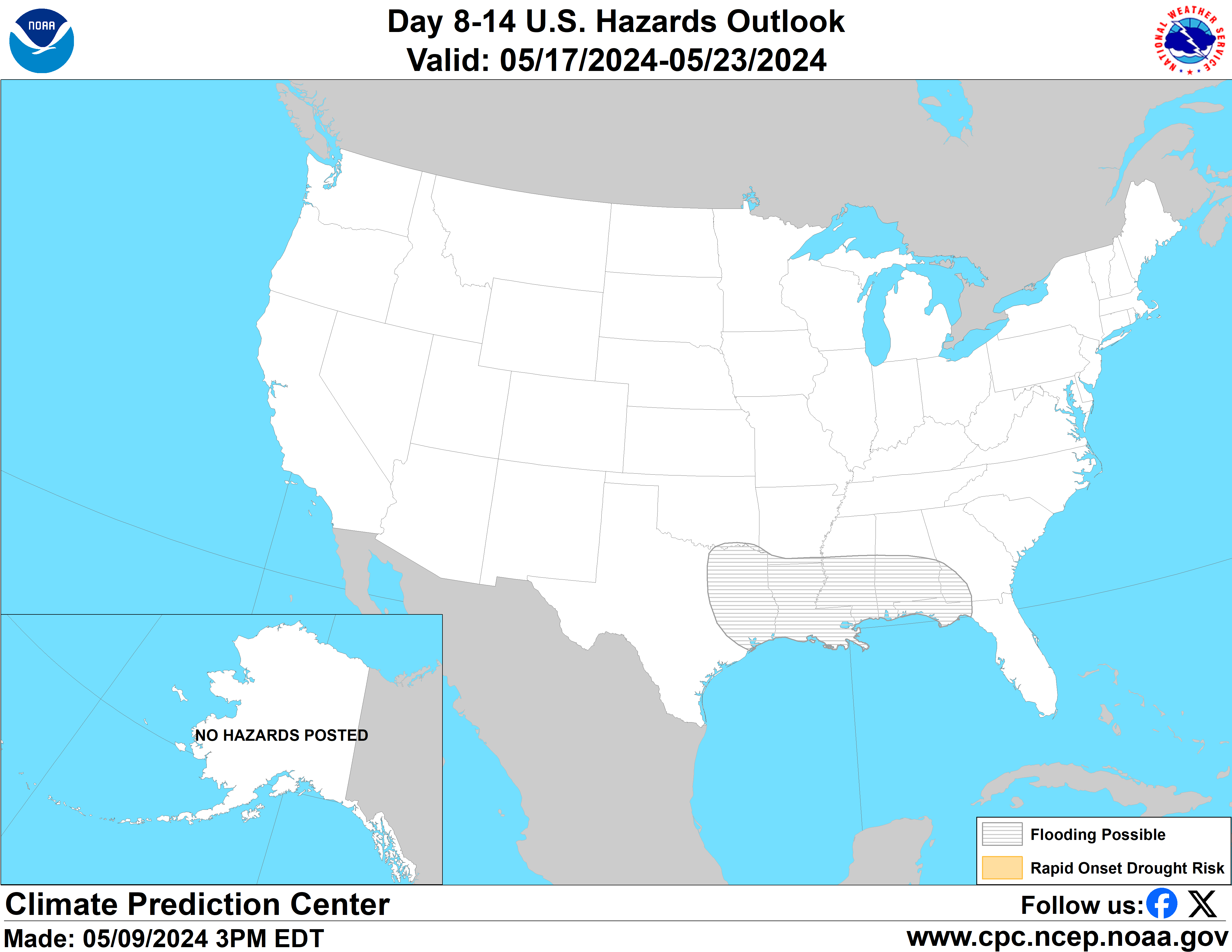 |
Valid Friday May 17, 2024 to Thursday May 23, 2024
US Hazards OutlookNWS Climate Prediction Center College Park MD
300 PM EDT May 09 2024
Synopsis: Early in week-2, a transient area of forecast mid-level low pressure sustains the risk of heavy precipitation and possible flooding for many parts of the southeastern contiguous U.S. (CONUS) and Mid-Atlantic. Upstream, building mid-level high pressure over the lower Four Corners is expected to bring unseasonably warm temperatures, renewing the risk of excessive heat conditions for parts of the Rio Grande Valley. Combined with drier than normal conditions and strengthening surface pressure, there is an increased risk of high winds which may elevate wildfire potential over the southwestern CONUS. Over Alaska, cooler than normal conditions are forecast as snowmelt and river ice breakup season is underway.
Hazards
- Slight risk for heavy precipitation for portions of the Lower Mississippi and Tennessee Valleys, Southeast, Appalachians, and Mid-Atlantic, Fri-Sat, May 17-18.
- Slight risk for excessive heat for parts of the Southern Plains, Sat-Tue, May 18-21.
- Slight risk of high winds for parts of the Four Corners and western High Plains, Fri-Tue, May 17-21.
- Flooding possible for parts of the Southern Plains, Lower Mississippi Valley and Southeast.
For Sunday May 12 - Thursday May 16: WPC Days 3-7 U.S. Hazards
For Friday May 17 - Thursday May 23: Since yesterday, the week-2 hazards perspective mostly remains on track, though there are a few new developments and discrepancies in the latest model guidance adding to more uncertainty in the updated outlook. Late in week-1, both the GEFS and ECMWF ensembles continue to feature anomalous 500-hPa ridging extending from the eastern Pacific into the western CONUS, with a fairly large coverage of anomalous troughing east of the Rockies. Within this negative height anomaly coverage, two shortwave disturbances have become more evident in the GEFS and ECMWF ensembles; one situated over the Tennessee Valley, and a secondary vorticity maximum associated with the possible remnants of a cutoff low upstream over northern Mexico. In the wake of a frontal system that remains favored to bring enhanced precipitation over the Southeast and Mid-Atlantic towards the middle of next week, this secondary feature is expected to renew the risk of heavy precipitation over parts of the southern and eastern CONUS heading into week-2. The return of potentially heavy precipitation is supported in both the uncalibrated and calibrated Probabilistic Extreme Tool (PET) guidance, thus the corresponding slight risk area is continued over southeastern CONUS, and extended through May 18. This area is expanded northward further into the Mid-Atlantic in the updated outlook where the uncalibrated ECMWF depicts greater than a 20% chance for 3-day precipitation amounts exceeding an inch.
A possible flooding hazard is also added in the outlook extending from eastern Texas and Louisiana (where some areas have registered more than 10 inches of rainfall in the past two weeks), eastward into parts of western Georgia and the Florida Panhandle where heavy precipitation is favored during week-1. Any additional precipitation during week-2 may trigger flash flooding as well as river flooding within the highlighted region, even in areas where precipitation deficits are currently registered.
As the secondary shortwave weakens and lifts out, both the GEFS and ECMWF favorincreasing mid-level heights over the Interior West and Great Plains, with a maximum height center amplifying over the lower Four Corners and northern Mexico. However, the ensembles are divided in regards to the pattern evolution both upstream and downstream. While the GEFS shows a sharper trend towards developing a trough over the eastern Pacific and West Coast, the ECMWF is virtually absent of this mid-level feature and maintains a widespread coverage of positive height departures which spread northward across the West Coast and into southwestern Canada. As a result of the stronger ridging over western North America, the ECMWF shows anomalous troughing redeveloping over the Midwest by the middle of the period, translating into predominantly cooler conditions than the GEFS over many parts of the central and eastern CONUS later in week-2. Notably, the ECMWF PET and uncalibrated tools depict the possible return of heavy precipitation over the Central Plains and Middle Mississippi Valley tied to the deepening trough aloft. No corresponding hazards are posted given no support in the GEFS PET, and significant differences among the models at this lead, but this troughing potential will continue to be monitored moving forward.
Despite these differences in the evolution of the height pattern, however, the potential for excessive heat still remains a concern across the southwestern and south-central CONUS given model consensus of the amplifying ridge center over the lower latitudes of North America. There is fair agreement in GEFS and ECMWF PETs indicating 20-30% chances for maximum temperatures exceeding the 85th percentile and 100 degrees F along the Rio Grande during the middle of week-2 , therefore a slight risk for excessive heat remains posted for the region (May 18-21). Similar heat signals are also evident further west across the Sonoran Desert of California and southern Arizona, though maximum temperatures are not expected to exceed hazard criteria over this part of the country for this time of year. The excessive heat potential will continue to be closely monitored over the Desert Southwest, lower Four Corners, and Southern Plains as these regions were plagued with excessive heat conditions for much of the warm season last year. With warmer and drier than normal conditions favored, a slight risk of high winds is also posted for parts of the Desert Southwest, Southern Rockies, and Southern Plains (May 17-21). This is supported in the GEFS and ECMWF PETs and raw ensembles depicting an anomalous surface high near the Front Range of Colorado which could induce episodes of high winds and elevate the wildfire risk.
No hazards are issued for Alaska. Snowmelt season is underway and frozen rivers are beginning to break up, leading to the potential for river flooding related to ice-jams. Currently, there are no indications of impending major river break-ups or serious threat of ice-jamming so no flooding-related hazards are posted at this time. Caution will continue to be exercised as river break-up can be unpredictable and local conditions can change quickly.
Forecaster: Nick Novella
$$ Please consult local NWS Forecast Offices for short range forecasts and region-specific information.
Resources
Week-2 Probabilistic Extremes Tool
GFS Ensemble Forecasts