|
|
General Information
|
Forecast Tools
|
Verification
|
Related Outlooks
|
About Us
|
Contact Us
|
As of the May 19th, 2017, release, Week 3-4 outlooks precipitation outlooks are experimental, whereas the temperature outlooks are operational. Both are issued Friday between 3pm & 4pm Eastern Time.
|
|
|
HOME>
Outlook Maps>
Week 3-4 Outlooks
|
|
|
Week 3-4 Outlooks
|
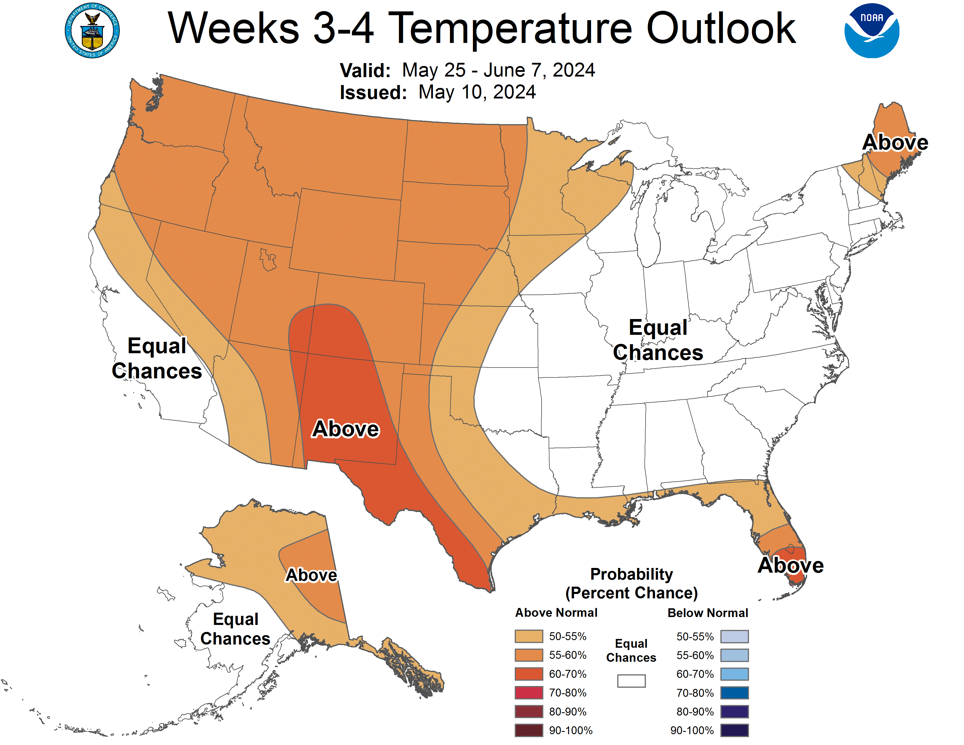
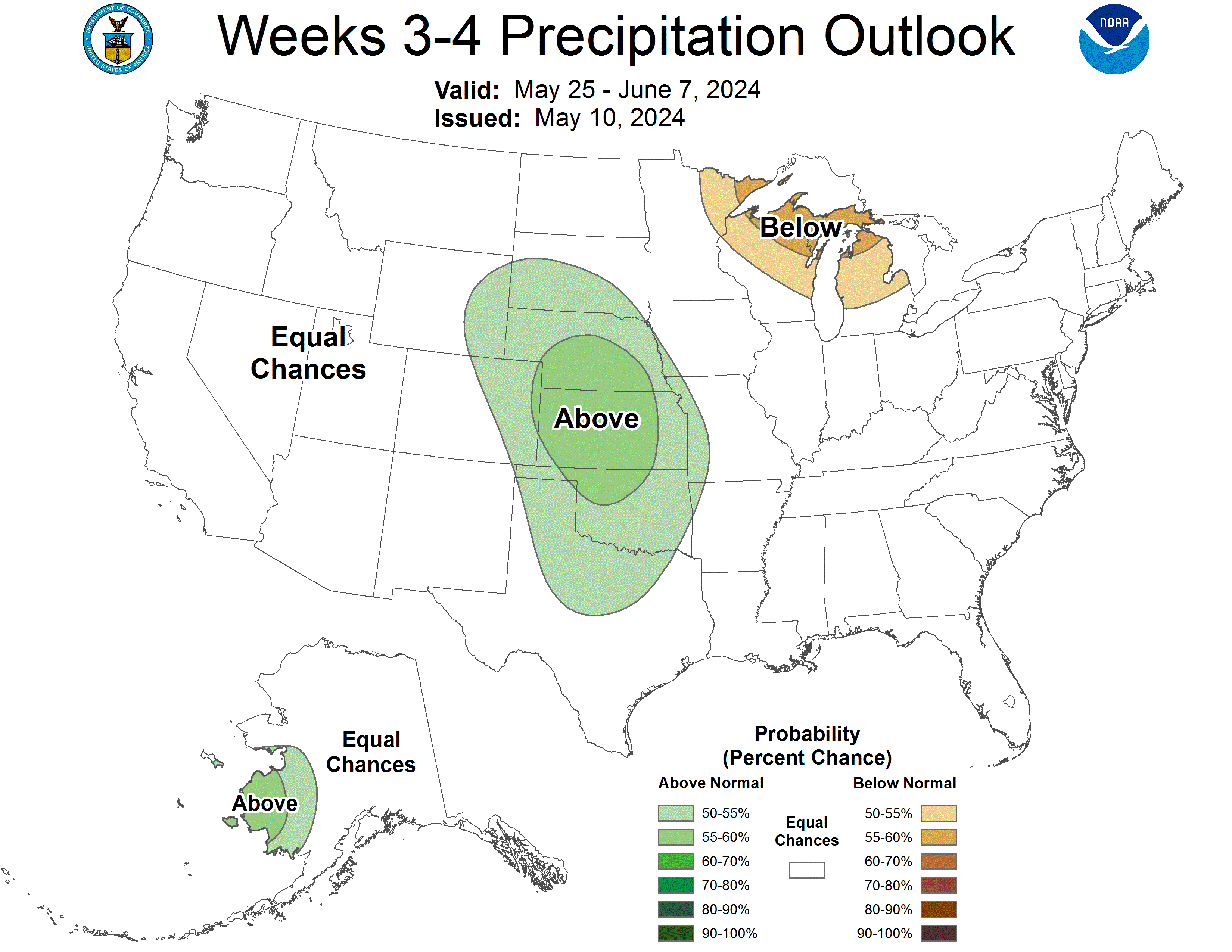
Valid: 25 May 2024 to 07 Jun 2024
Updated: 10 May 2024
|
|
Temperature Probability
|
Precipitation Probability
(Experimental)
|
Experimental Week 3-4 500mb Outlook
|
|
Click HERE for info about how to read Week 3-4 outlook maps
|
|
Prognostic Discussion for Week 3-4 Temperature and Experimental Precipitation Outlooks
NWS Climate Prediction Center College Park MD
300PM EDT Fri May 10 2024
Week 3-4 Forecast Discussion Valid Sat May 25 2024-Fri Jun 07 2024
The transition from El Niño to ENSO-neutral conditions is well underway as below-average equatorial sea surface temperature anomalies recently developed across parts of the eastern Pacific and convection was near average throughout the equatorial Pacific and Indonesia during the past month. The Madden-Julian Oscillation (MJO) briefly strengthened during late April with an eastward propagation of the MJO from the Indian Ocean to the western Pacific by early May. However, in the past few days the amplitude of the RMM-based MJO index decreased. Dynamical model forecasts agree that the MJO remains relatively weak during the next two weeks with large model spread by week-3. Neither ENSO nor the MJO is expected to be a major influence on the mid-latitude circulation pattern during late May and early June. The Weeks 3-4 Temperature and Precipitation Outlooks are based on dynamical model forecasts from the CFS, GEFS, ECMWF, JMA, and SubX multi-model ensemble (MME) of experimental GEFS and CFS ensemble prediction systems. A statistical Multiple Linear Regression (MLR) tool which includes input from the El Niño Southern Oscillation (ENSO), MJO, and decadal trends was also used.
The GEFS and ECMWF ensemble means diverge as early as the week-2 period with their 500-hPa height patterns. The GEFS depicts a full-latitude ridge over western North America with an amplified trough downstream across eastern North America. The ECMWF ensemble mean is nearly out of phase as it has a weak trough along the West Coast and a ridge near the East Coast. Due to these large model differences prior to week-3, expectation of little to no tropical forcing, and lack of predictability with shorter wavelengths during the spring, forecast confidence is low for many areas which led to limited probabilities.
The manual 500-hPa height blend, most heavily weighted with the ECMWF, GEFS, and JMA models, depicts positive height anomalies throughout North America. These anomalous mid-level heights along with neutral to positive trends during late May and early June favor above-normal temperatures for a majority of the contiguous U.S. (CONUS) and Alaska. Good model agreement and low soil moisture resulted in above-normal temperature probabilities exceeding 60 percent across parts of New Mexico and the Rio Grande Valley. Soil moisture is above the 90th percentile across southern Arkansas, northwestern Louisiana, and northeastern Texas. During the next week to ten days, additional heavy rainfall is likely to maintain these saturated soils and this could provide at least a slight cooling effect on surface temperatures for northeastern Texas and the lower Mississippi Valley. This was a consideration in the week 3-4 temperature outlook and supported going with equal chances (EC) of below or above-normal temperatures. EC are also forecast for a majority of the eastern CONUS since the CFS and GEFS have a 500-hPa trough either near the Mississippi Valley or East Coast. The exception to the EC includes Florida and northern New England based on good model agreement for increased chances of above-normal temperatures.
Dynamical models are in good agreement for an elevated chance of above-median precipitation from South Dakota to Texas and the Week 3-4 outlook followed this model guidance. This wet signal seems to be related to southern stream shortwave troughs undercutting a mean 500-hPa ridge centered to the north over western Canada. Downstream of that ridge axis along with model support, below-median precipitation is slightly favored across parts of the Great Lakes and upper Mississippi Valley. Weak and/or conflicting signals among the dynamical models along with lower predictability with convective precipitation resulted in a large coverage of equal chances (EC) of below or above-median precipitation for the remainder of the CONUS and much of Alaska. Elevated probabilities for above-median precipitation are forecast for parts of western Alaska where the calibrated ECMWF and JMA models agree.
The SubX MME favors above-normal temperatures for Hawaii, but probabilities are relatively low due to near average SST anomalies surrounding the state and the uncalibrated GEFS and ECMWF have little to no signal. Based on the SubX MME, above-median precipitation probabilities are slightly elevated for Honolulu and Lihue.
| Temperature | Precipitation |
| FCST | FCST |
| Hilo | A55 | EC |
| Kahului | A55 | EC |
| Honolulu | A55 | A55 |
| Lihue | A55 | A55 |
Forecaster: Brad Pugh
The next week 3-4 outlook will be issued on Friday, May 17, 2024
These outlooks are based on departures from the 1991-2020 base period
These are two category outlooks and differ from official current three category outlooks currently used for the monthly and seasonal forecasts.
The shading on the temperature map depicts the most favored category, either above-normal (A) or below-normal (B) with the solid lines giving the probability ( >50%) of this more likely category (above or below).
The shading on the precipitation map depicts the most favored category, either above-median (A) or below-median (B) with the solid lines giving the probability ( >50%) of this more likely category (above or below).
In areas where the likelihoods of 2-week mean temperatures and accumulated precipitation amounts are similar to climatological probabilities, equal chances (EC) is indicated.
As of May 19, 2017, the temperature outlook is operational, while the precipitation outlook is still experimental
|
|
|
|
An ASCII (w/ HTML markup tags) text version of the written forecast is available.
|
|
|