HOME> Expert Assessments>Hazards Outlook
For 3-7 day hazards see Weather Prediction Center's: WPC 3-7 Day Hazards
U.S. Week-2 Hazards Outlook - Made May 10, 2024 | About the Hazards Outlook
ATTENTION:
For more information on the addition of the experimental Rapid Onset Drought hazard type to the Climate Prediction Center's 8-14 Day Hazards Outlook (Contiguous U.S. and Alaska), please click HERE.
To provide feedback, please answer the SURVEY.
Valid Saturday May 18, 2024 to Friday May 24, 2024
US Hazards OutlookNWS Climate Prediction Center College Park MD
300 PM EDT May 10 2024
Synopsis: There is significant disagreement among the dynamical models reducing confidence in the week-2 outlook. Late in week-1, forecast low pressure at the mid-levels and at the surface is expected to increase the risk of heavy precipitation for parts of the Mid-Atlantic and Northeast continuing into the outset of week-2. Near to above-normal precipitation predominately favored from the Southern Plains to the Southeast may trigger localized flooding across parts of the Gulf states during week-2 following rounds of heavy precipitation forecast during week-1. Over Alaska, cooler than normal conditions are forecast as snowmelt and river ice breakup season is underway.
Hazards
- Slight risk for heavy precipitation for portions of the Northeast, Appalachians, and Mid-Atlantic, Sat, May 18.
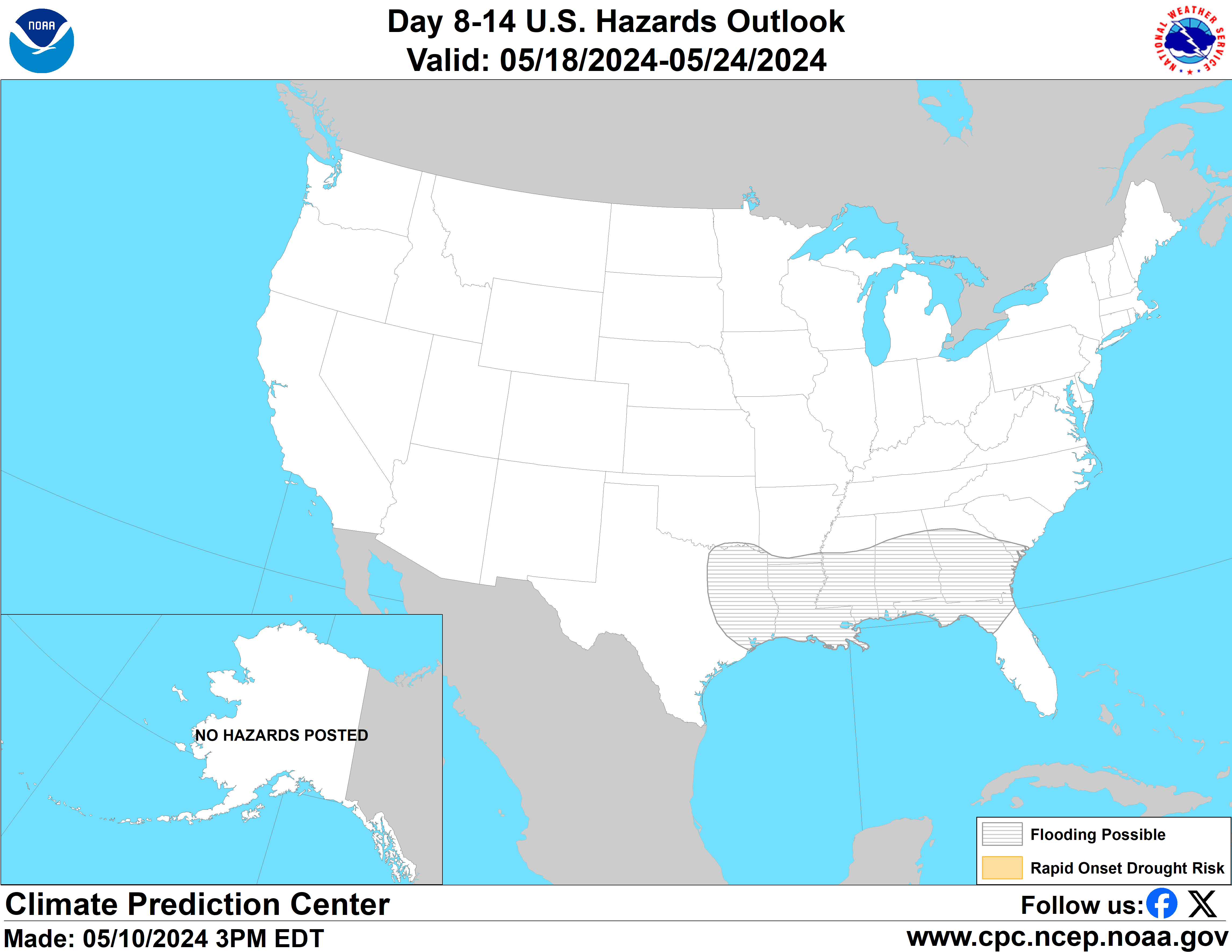
- Flooding possible for parts of the Southern Plains, Lower Mississippi Valley and Southeast.
For Monday May 13 - Friday May 17: WPC Days 3-7 U.S. Hazards
For Saturday May 18 - Friday May 24: For what appears to be firmly in-line with the challenges of springtime weather prediction, the latest runs of the GEFS and ECMWF ensemble mean 500-hPa height fields continue to show poor run-to-run continuity, with significant disagreements in the overall evolution of the height pattern contributing to large uncertainty in the outlook. Notwithstanding, model consensus is at its highest leading into the week-2 period, where both ensembles continue to feature some form of shortwave activity lifting out across the Plains and Mississippi Valley. Compared to yesterday, the 0z and 6z GEFS feature a much more amplified trough aloft over the eastern CONUS, with a stronger accompanying surface low that deepens over the Great Lakes while bringing increased precipitation amounts over many parts of Eastern Seaboard at the start of week-2. The ECMWF has become considerably weaker with this mid-level feature, but uncalibrated guidance maintains a modest threat of heavy precipitation over many parts the Mid-Atlantic and the Northeast associated with the mean surface low, as several ensemble members also are beginning to point to a secondary cyclonic surface feature forming offshore in the Atlantic. Although Probabilistic Extremes Tools (PETs) have become less supportive of the heavy precipitation potential early in week-2, a slight risk of heavy precipitation is posted (May 18) based on the uncalibrated guidance and continuity with previous hazard outlooks.
A possible flooding hazard remains issued in the outlook extending from eastern Texas eastward into parts of western Georgia and the Florida Panhandle where heavy precipitation is favored based on the Weather Prediction Center's (WPCs) week-1 QPF outlook. Despite more uncertainty with the risk of heavy precipitation returning to the southeastern CONUS later in week-2, the continuation of above-normal precipitation predominately favored in the region may trigger flash flooding as well as river flooding within the highlighted region, even in areas where precipitation deficits are currently registered.
Beyond days 8 and 9, mean ensemble solutions vary wildly between the GEFS and ECMWF leading to the discontinuation of a pair of hazards previously posted in the southern CONUS. In regards to excessive heat potential across the Southern Plains, the ECMWF maintains the amplification of an anomalous 500-hPa ridge center over the lower latitudes of North America, with increased chances for maximum temperatures exceeding the 85th percentile in its PET over the Southern Plains and lower Four Corners by next weekend. However, the aforementioned deeper troughing favored in the latest GEFS establishes more northwesterly flow and colder air overspreading many parts of the Plains and Mississippi Valley early in the period. Even after this troughing weakens and lifts out after next weekend, the mid-level flow becomes appreciably more zonal than the ECMWF, reducing confidence for the renewal of excessive heat potential later in May. Similarly, pressure gradients in the mean surface fields appear more neutral, lowering the risk of elevated winds, as the potential for anomalously cold air in the GEFS would also help to quell any associated wildfire risks over the Southern Plains.
No hazards are issued for Alaska. Snowmelt season is underway and frozen rivers are beginning to break up, leading to the potential for river flooding related to ice-jams. Currently, there are no indications of impending major river break-ups or serious threat of ice-jamming so no flooding-related hazards are posted at this time. Caution will continue to be exercised as river break-up can be unpredictable and local conditions can change quickly.
Forecaster: Nick Novella
$$ Please consult local NWS Forecast Offices for short range forecasts and region-specific information.
Resources
Week-2 Probabilistic Extremes Tool
GFS Ensemble Forecasts
