|
1. Northern Hemisphere
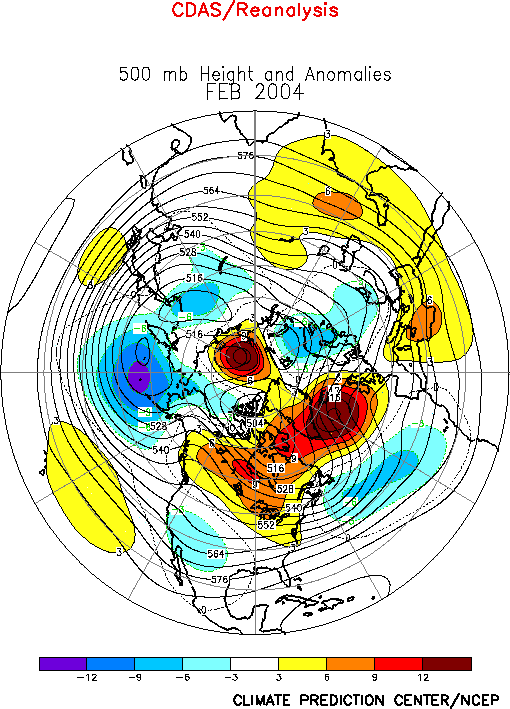
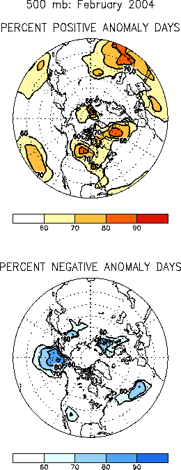
The 500-hPa circulation during
February 2004 featured above-average
heights across Canada, the North Atlantic, and the polar region, and
below-average heights over the high latitudes of the North Pacific, the
southwestern U.S., the central North Atlantic, and Scandinavia (Fig.
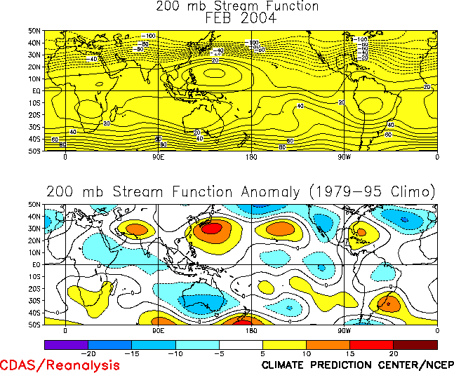
E10). In the subtropics the circulation featured an anomalous
anticyclonic circulation across nearly the entire hemisphere (Fig.
T22 bottom), with the largest anomalies evident along the
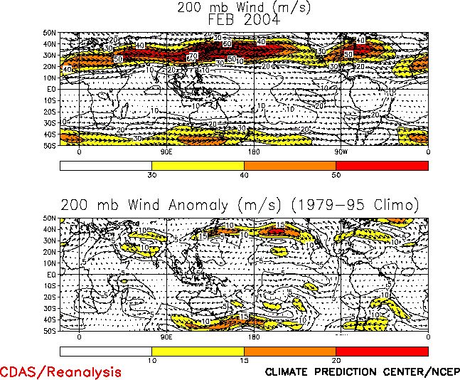
equatorward flank of the East Asian jet stream (Fig.
T21). A corresponding anomalous anticyclonic circulation was also
evident in the Southern Hemisphere across Australia and the South Pacific.
In the Northern
Hemisphere this anomaly pattern was associated with an
enhanced East Asian jet stream extending well east of normal, and with an
eastward shift in the associated jet exit region to just upstream of
California (Fig. T21). It was also
associated with a southward shift of the North Atlantic jet stream, and
with a near absence of upper-level westerlies over the eastern North
Atlantic and Europe.
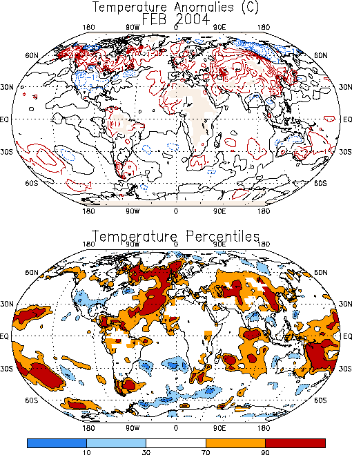
Prominent temperature
departures during February included significantly
warmer than average conditions across Alaska and Canada, southern Russia,
and China, and a continuation of warmer than average SSTs over large
portions of the North Atlantic (Fig. E1).
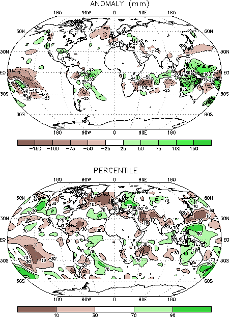
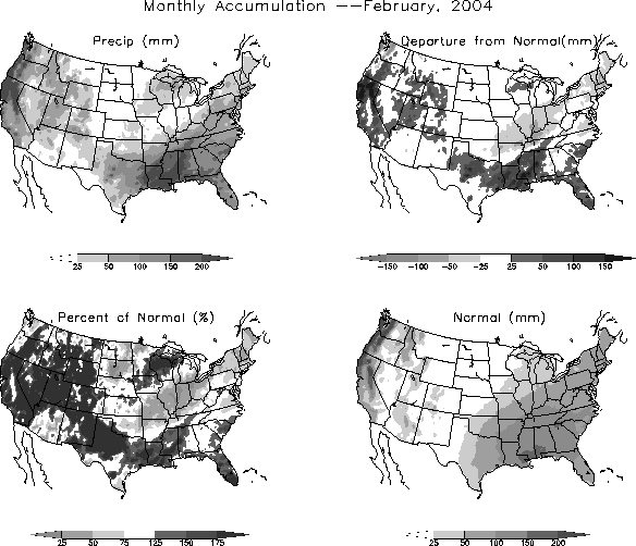
Prominent precipitation anomalies during the month included above-average
totals in California, the Inter-Mountain and Gulf Coast regions of the
U.S., and eastern Europe, and below-average totals over the mid-western and
northeastern U.S. (Figs. E3, E5,
E6).
a. Pacific/North America
The mean upper-level
circulation during February featured persistent
north-south-dipoles of height anomalies over both the eastern North Pacific
and western North America, with a change in sign of the anomalies occurring
between the two regions (Figs. E10, E12).
This circulation was associated with an eastward extension of the East
Asian jet stream, and with a pronounced split-flow configuration over
western North America. The northern branch of this split flow pattern
brought mild, marine air into Canada and contributed to above-average
surface temperatures across the country (Fig. E1).
The southern branch of the jet stream was associated with a pronounced
southward shift of the storm track, and brought increased storminess and
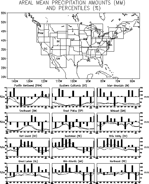
above-average precipitation to the southern tier of the U.S. (Fig.
E3), while also leaving a swath of below-average totals from
Missouri northeastward to Maine (Fig. E6).
The Inter-Mountain
region of the western U. S. has received
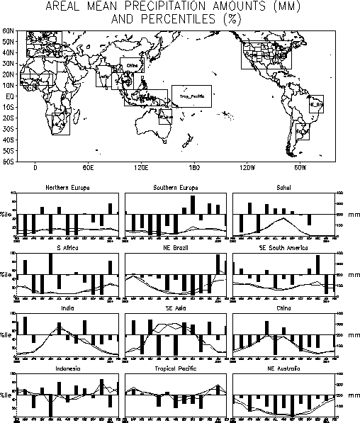
above-average precipitation in three of the last four months (Fig.
E5), and also recorded above-average totals during the 2002-03
winter. This region had previously experienced large precipitation deficits
during the prolonged 1998-2001 Pacific cold episode. For the Gulf Coast and
Southeast regions of the U.S., February marks the first month of
above-average precipitation since August 2003.
b. North Atlantic/Eurasia
Over the North
Atlantic positive 500-hPa height anomalies at high
latitudes reflected a continued absence of the mean Icelandic Low. These
anomalies, combined with below-average heights in the middle latitudes,
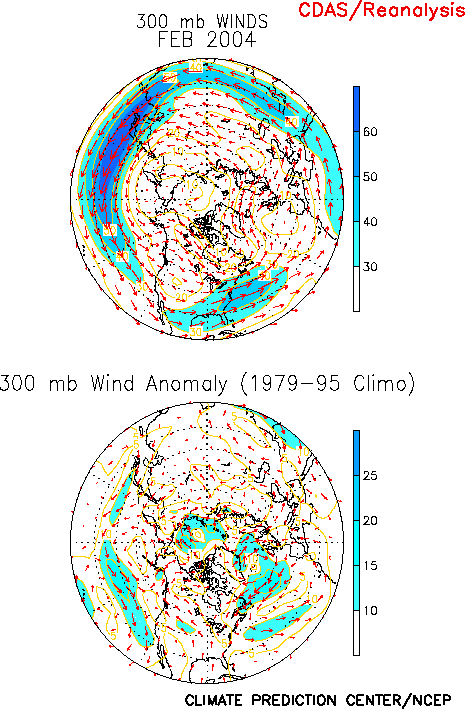
were associated with enhanced jet stream winds (Fig.
E11) and increased storminess (Fig. E14)
over the western North Atlantic. They were also associated with a
pronounced split flow pattern across the eastern North Atlantic and western
Europe, with the northern branch of the flow extending across Iceland and
central Scandinavia, and the southern branch extending across the
Mediterranean Sea primarily during the second half of the month (Fig.
A2.1). This circulation, combined with the exceptionally warm SSTs
at high latitudes, contributed to a continuation of above-average surface
temperatures over Great Britain (Fig. E1).
The main
precipitation anomalies during February were observed in
eastern Europe, where totals in some areas exceeded the 90th
percentile. Much of this precipitation occurred during the second half of
the month when a well-developed southern branch of the jet stream brought
increased storminess to the region (Fig. A2.1).
c. Central Russia and China
Much of central Russia experienced well above-average surface
temperatures during February in response to broad southwesterly flow
between the mean upper-level trough and ridge axes (Fig.
T22 top). Central China also experienced above-average surface
temperatures in response to broad upper-level southwesterly flow along the
equatorward flank of the enhanced East Asian jet entrance region (Fig.
T21).
2. Southern Hemisphere
In the
Southern Hemisphere the 500-hPa circulation during February
featured above-average heights over Antarctica, southern South America, and
the subtropics from Australia to the central South Pacific, and
below-average heights in the middle latitudes from the central Indian Ocean
to the eastern South Pacific, and across the subtropical western South
Atlantic. (Figs. E16, T22).
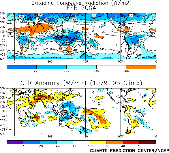
This circulation was associated with enhanced tropical convection across
northern Australia (Fig. T25), and a
poleward shift of the South Pacific jet stream to approximately 45°S
(Fig. T21). Southeastern Australia
experienced below-average precipitation in response to its location along
the anticyclonic flank of the jet core (Fig. E3).
Over South
America anomalously warm conditions were observed in the
extreme south beneath the persistent upper-level ridge axis. Eastern Brazil
experienced wetter-than-average conditions, while northeastern Argentina,
Uruguay, and southern Brazil were drier than average for the second
consecutive month (Figs. E3, E4).
This dipole pattern is consistent with the anomalous mid- and upper-tropospheric
cyclonic circulation observed over the western South Atlantic (Figs. T21,
E16).
In southern
Africa the rainy season normally lasts from October to
March. Area-averaged rainfall was near-normal during February (Fig.
E4, with portions of northeastern South Africa receiving
above-average totals (Fig. E3) and portions
of Mozambique and Tanzania receiving below-average rains. Overall, the
2003-2004 rainy season has been below-average, with significantly
below-average totals during November and December and above-average totals
in January.
|


