1. Northern Hemisphere
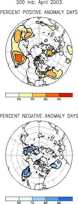
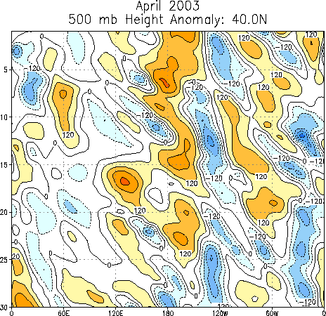
The 500-hPa circulation during April 2003 featured positive height
anomalies over the central latitudes of the North Pacific, the Norwegian
Sea, Scandinavia, and western Europe, and negative height anomalies over
the western United States, eastern Canada, the central North Atlantic, and
eastern Siberia (Figs. E10, E12).
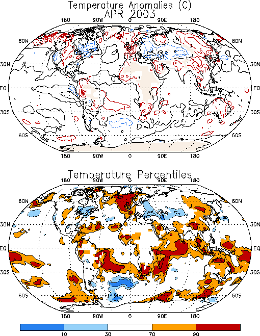
The prominent temperature anomalies during April included
cooler-than-average conditions over the western United States, eastern
Canada, and in both the Black Sea and Caspian Sea regions, and
warmer-than-average temperatures over the central United States, western
Europe, China, and portions of eastern Russia (Fig.
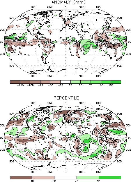
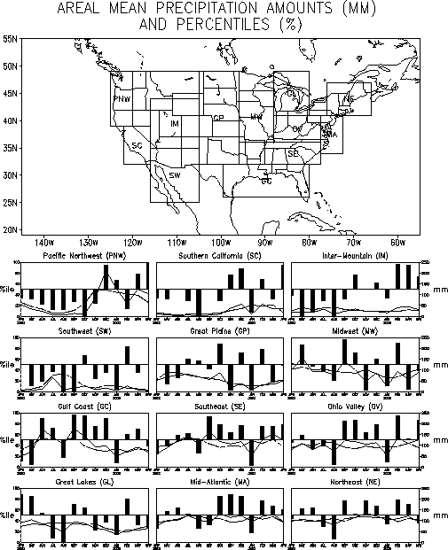
E1). Prominent precipitation anomalies during the month (Fig.
E3) included a continuation of above-average totals in the Pacific
Northwest, Inter-Mountain, and mid-Atlantic regions of the United States (Fig.
E5), and continued below-average precipitation over much of Europe
(Fig. E4).
a. Pacific/North America
The upper-level circulation over the North Pacific featured a persistent
pattern of above-average heights in the middle latitudes, and below-average
heights over the high latitudes of the western North Pacific and eastern
Siberia (Figs. E12, E13).
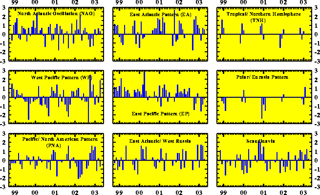
These anomalies were associated with a strong positive phase (+1.9) of the
West Pacific teleconnection pattern (Table E1, Figs.
E7, E8). They
were also associated with a below average strength of the East Asian jet
stream across the western and central Pacific (Fig. T21).
Over the United States a persistent upper-level tough in the West (Fig.
E12) contributed to a continuation of above-average precipitation in
the Pacific Northwest and Inter-Mountain regions, and to well above-average
precipitation over most of California (Figs E3, E5). These areas
also experienced below average temperatures during the month.
The largest positive surface temperature anomalies during April were
observed over Alaska (+2° to +4°C),
and the largest negative anomalies (-1 to -3°C)
were observed over eastern Canada in association with an amplification of
the mean Hudson Bay trough. Most of the central U.S. recorded slightly
above average surface temperatures during the month, while the eastern
seaboard and northeast regions experienced slightly below-average
temperatures.
b. Europe
The upper-level circulation during April featured a ridge across the
high latitudes of the North Atlantic and western Europe, and a
full-latitude trough extending from northwestern Russia southward to the
eastern Mediterranean Sea (Fig. E10). This circulation contributed
to a continuation of anomalously warm conditions over much of Europe and to
anomalously cool conditions across southwestern Russia (Fig. E1).
The persistent upper level circulation also contributed to continued
drier than average conditions in western Europe, with monthly precipitation
totals falling below the 10th percentile in that region (Fig.
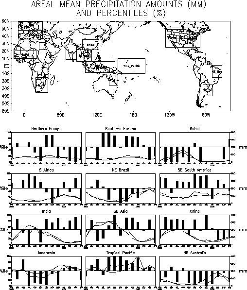
E3). For Europe as a whole, area-averaged precipitation totals in the
Northern Europe region have been below the 10th percentile since
February, and area-averaged totals in the Southern Europe region have been
in the 20-30th percentile range since March (Fig.
E4).
2. Southern Hemisphere
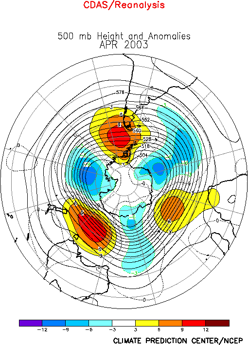
In the Southern Hemisphere the 500-hPa circulation during April featured
an anomalous zonal wave-3 pattern, characterized by above-average heights
south of each of the three continents, and below-average heights over the
high latitudes of the three ocean basins (Fig. E16). Surface
temperatures in southern Africa were 2°-3°C
above average during April, which is above the 90th percentile
of occurrences (Fig. E1). Most of southeastern Africa experienced
warmer and drier than average conditions during April, which marks the end
of that region’s rainy season. In Australia temperatures were slightly
above average (+1°C) over the eastern half of
the continent during April, while rainfall was below average in the
northeast and along the east coast.


