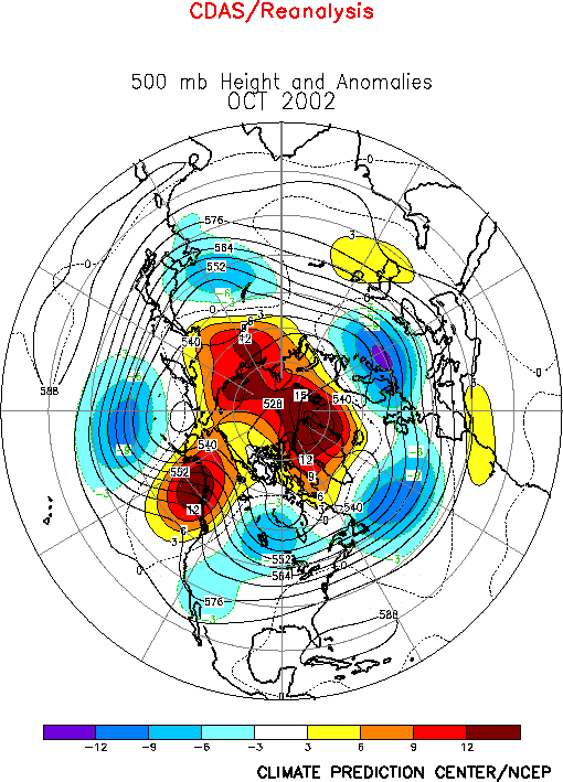
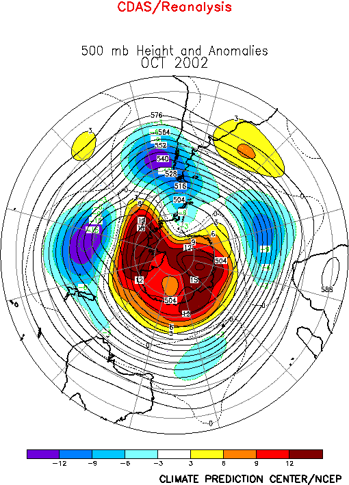
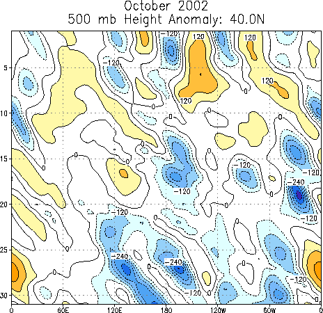
The 500-hPa circulation during October featured
above-average heights and blocking activity at high latitudes, and
below-average heights in the middle latitudes (Fig. E10). These
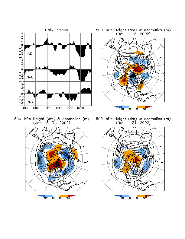
anomalies were associated with the negative phases of the Arctic
Oscillation (Fig. A2.1) and North Atlantic Oscillation (-1.4)
and a strong positive phase (2.5)of the West Pacific Oscillation (Table
E1, Figs. E7, E8). Similar anomaly patterns were also observed in
the South Hemisphere (Figs. E16, S1).
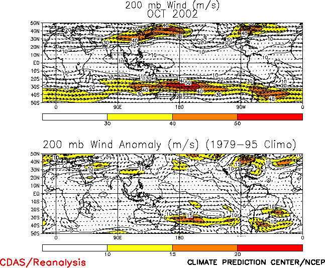
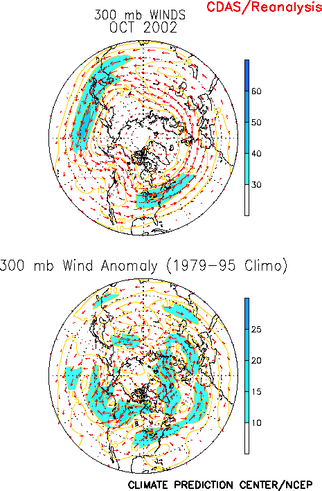
In the Northern Hemisphere cyclonic streamfunction anomalies were
observed throughout the middle latitudes at 200-hPa, with the largest
anomalies extending along an axis from northern Africa to the central
North Pacific, and from central North America to central Europe (Fig.
T22). These conditions were associated with an increased strength
of the mid-latitude westerlies across Asia, the United States, and the
North Atlantic (Fig. T21), and a decrease in westerly wind
speeds at higher latitudes between 50°N-70°N (Fig. E13).
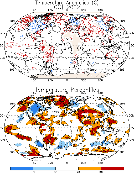
Exceptionally cool conditions prevailed across North America,
northern Europe, Scandinavia, and northern Asia during the month (Fig.
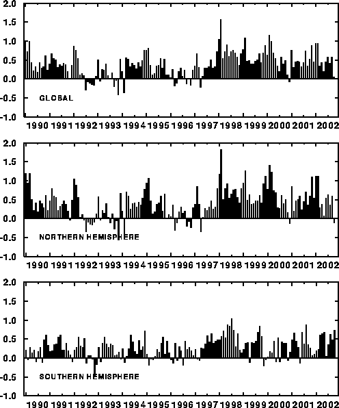
E1), resulting in slightly below-average monthly mean temperatures
for land regions averaged over the entire hemisphere (Fig. E2
middle), and in near-average mean temperatures for land areas
averaged over the entire globe (Fig. E1 top). Prominent
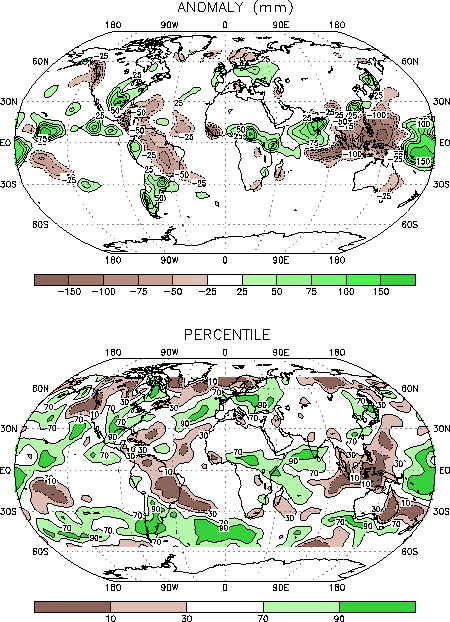
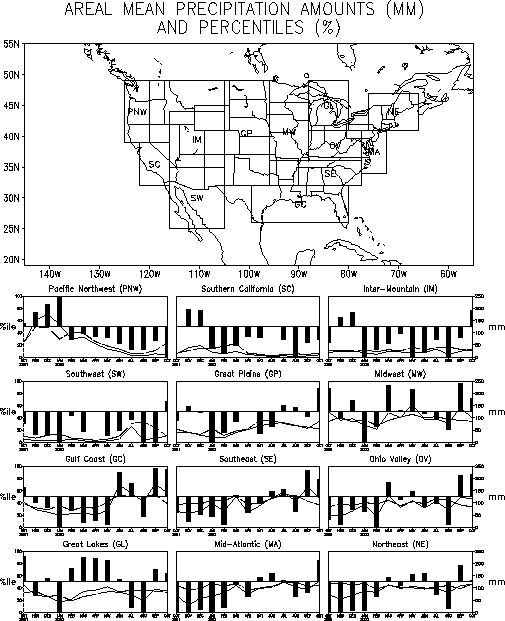
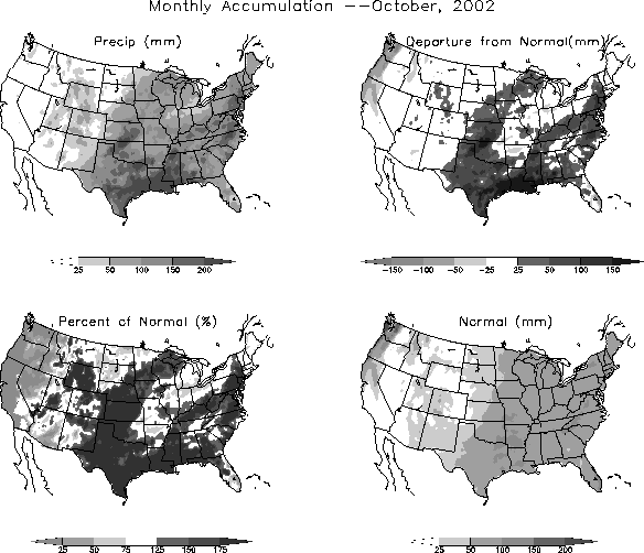
precipitation departures during the month included continued dryness
in the Pacific Northwest region of the United States (Figs. E3,
E5, E6) and above-average rainfall across the southeastern states and
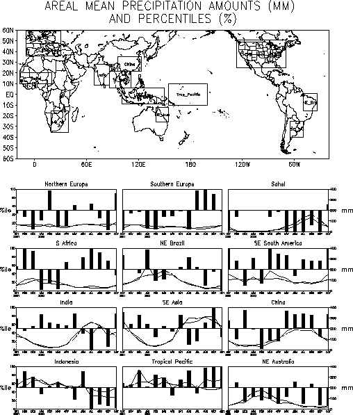
portions of northern Europe (Figs. E3, E4).
a. North America
The mean circulation during October featured a ridge over the Gulf
of Alaska and a trough extending from central Canada to the
southwestern United States (Fig. E10), in association with a
westward shift of the mean ridge and trough axes from their normal
locations over the Rocky Mountains and eastern North America,
respectively. These conditions were associated with significantly
below-average surface temperatures (below the 30th
percentile) over most of North America, with the largest departures (-3° to -5°C)
observed from central Canada to Texas (Fig. E1).
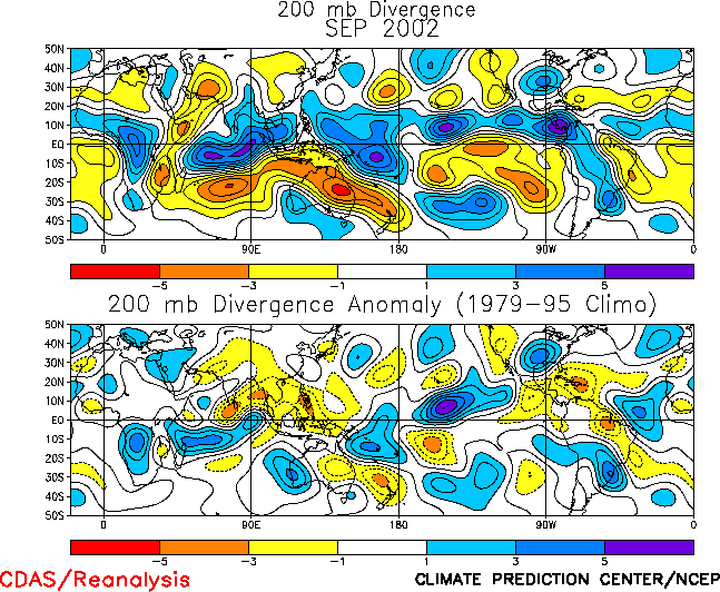
The primary region of above-average precipitation (Fig. E3)
and upper-level divergence during October was observed over the
southeastern U.S. (Fig. T23). This region was situated
downstream of the mean upper-level trough axis along the right-entrance region of an enhanced North Atlantic jetstream (Figs.
E11, T21). Below-average precipitation was observed mainly in the
Pacific Northwest immediately downstream of the mean upper-level ridge axis. This area has recorded precipitation deficits in every month
since February 2002.
b. North Atlantic and Europe
The circulation over the North Atlantic and Europe featured
above-average heights at high latitudes and below-average heights in
the middle latitudes (Fig. E10). Enhanced jet stream winds were
also observed across the central Atlantic in association with a southward shift of the mean jet axis to central Europe (Figs. E11,
T21). These conditions are consistent with a strong negative phase
(-1.4) of the NAO ((Table E1, Figs. E7,
E8), and were associated with above-average precipitation from the eastern North
Atlantic to the Caspian Sea (Fig. E3). They also contributed to
below-average surface temperatures across northern Europe and Scandinavia, with departures in some areas falling below the 10th
percentile of occurrences (Fig. E1).
2. Southern Hemisphere
a.Troposphere
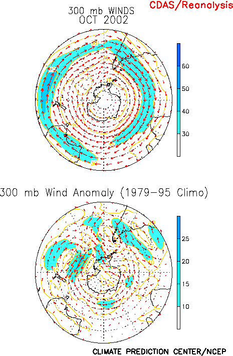
The upper-level circulation during October featured above-average
heights throughout the polar region extending well into the upper
stratosphere (Figs. S1, S2 top), and below-average heights in
the middle latitudes (Fig. E16). This circulation was
associated with a markedly reduced strength of the Antarctic
circumpolar vortex (Fig. E17). It was also associated with an
extended jet stream in the middle latitudes (near 40°N)
from southern Australia to the central South Atlantic (Fig. T21),
with above-average precipitation totals found along the poleward
(cyclonic shear) flank of the jet (Fig. E3 bottom).
Prominent precipitation anomalies during October also included a
dipole pattern over South America, characterized by above-average
amounts in the Northeast and North and above-average amounts in the
South (Figs. E3, E4). This pattern is consistent with the
ongoing El Niño conditions. Below-average precipitation was also observed across
eastern Australia, with monthly totals generally below the 10th percentile throughout the region.
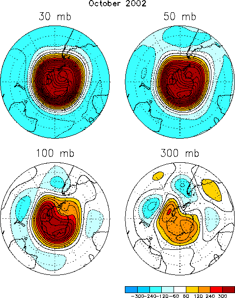
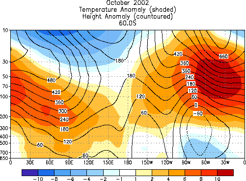
b. Stratospheric Ozone
A persistent pattern of above-average heights and temperatures has
prevailed over Antarctica during September and October. These
conditions have reflected a pronounced stratospheric warming between
300-hPa and 30-hPa, with the largest temperature anomalies (exceeding
+12°C) found near the 70-hPa level (Fig. S2 bottom). At 50-hPa monthly mean temperatures in the polar
region (averaged between 65°S-90°S) were approximately 10°C above normal
during October (Fig. S3, bottom right), which is close to the
+11°C departure observed in September.
This warming has been associated with a markedly reduced strength
of the Antarctic circumpolar vortex (Fig. E17), and with a
decrease in size of that vortex to its lowest value since at least
1992 (Fig. S8, middle). The warmth also resulted in a complete
disappearance of polar stratospheric clouds over Antarctica by late
September (Fig. S8, bottom), and to a near-disappearance of the
associated ozone hole (Fig. S8, top). The mean size of the
ozone hole during October averaged only 6 x 10⁶ km2,
which is nearly 35% of the 1992-2001 mean size of approximately 17 x 106 km2.


