The 500-hPa circulation
pattern during December featured above-average heights across the high
latitudes of the North Pacific, the central North Atlantic, and central
Siberia, and below-average heights over eastern
Canada
and the
Mediterranean Sea
(Figs. E9, E11). This
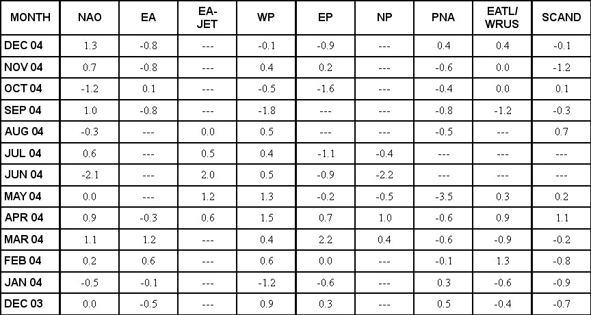
circulation was associated with a continued strong positive phase of the
North Atlantic Oscillation (Table E1, Fig. E7), and the ongoing warm
phase of the Atlantic multi-decadal mode.
The main temperature
departures during December included warmer than normal conditions over the
northwestern
United States
, and both northern and eastern Europe, and below-average temperatures over
eastern
Canada
and eastern
Siberia
(Fig. E1). The main precipitation departures included above-average
totals in the western and northeastern
U.S.
, and in south-central
Europe
(Fig. E3).
a. North America
The mean circulation pattern
during December featured weak positive 500-hPa height anomalies in the
northwestern
U.S.
, and negative height anomalies over
Hudson Bay
(Fig. E9). This pattern prevailed mainly during the second half of
the month (Fig. A2.1), when it contributed to above-average
temperatures in the northwestern
U.S.
and below-average temperatures over eastern
Canada
(Fig. E1).
Precipitation during December
was above average from the Great Lakes to New England, and in both the
Inter-Mountain and Southern California regions of the
United States
(Figs. E3, E5). The Inter-Mountain region has recorded above-average
precipitation in each of the last four months (Fig. E5), which has
helped to moderate the long-term drought conditions plaguing the region.
Rainfall in southern
California
has also been above average during the last three months, with area-mean
totals exceeding the 90th percentile of occurrences during both
October and December.
b. North Atlantic/Eurasia
Above-average 500-hPa heights were again observed
across the high latitudes of the North Atlantic during December, and
below-average heights covered
Greenland
(Fig. E9). This anomaly pattern reflected a strong positive value
(+1.3) of the NAO (Table E1, Fig. E7). These conditions were
associated with an enhanced flow of marine air into northern Europe and
Scandinavia
(Fig. E10), and with a pronounced split-flow pattern across central
and southern
Europe
. A large-amplitude trough embedded within the southern branch of this split
flow brought above-average precipitation to south-central Europe, with
totals over
Italy
and the
Mediterranean Sea
exceeding the 70th percentile of occurrences.
The
North Atlantic
also saw a continuation of exceptionally warm SSTs at both high latitudes
and in the subtropics. This warmth reflects the ongoing warm phase of the
Atlantic multi-decadal mode that began approximately in 1995 (Goldenberg et
al. Science, 2001).
In contrast,
eastern
Siberia
experienced well below average surface temperatures during December, with
values in many areas ranging from 3°-5°C below average (Fig. E1).
These exceptionally cold conditions occurred downstream of a persistent
upper-level ridge over central
Siberia
.
2. Southern Hemisphere
The 500-hPa circulation pattern during December
featured a persistent zonal wave-4 pattern in the middle latitudes (Figs.
E15, E17). At 200-hPa anticyclonic streamfunction anomalies prevailed
across the lower latitudes of the South Pacific (Fig. T22). Over the
eastern South Pacific the combination of negative height anomalies in the
middle latitudes and positive height anomalies at lower latitudes was
associated with an enhanced jet stream extending eastward into southern
South America
(Fig. T21). This circulation contributed to anomalously warm and wet
conditions across the region, with monthly temperature and precipitation
departures generally exceeding the 70th percentile of
occurrences.
In southern
Africa
the rainy season normally lasts from October to April. During December
area-mean precipitation totals were above average (Fig. E4), with the
largest departures occurring in central and northeastern parts of the region
(Fig. E3). This is the first month that above-average rains were
observed during the 2004-2005 rainy season. Exceptionally warm conditions
were also observed in South Africa during December, along with near-record
sea-surface temperatures (ranging from 1°-2°C above average) surrounding
the country. These anomalously warm and wet conditions were associated with
positive 500-hPa height anomalies, below-average upper-level westerlies, and
below-average surface pressures, across the region (Fig. T19).
In
Australia
, anomalously dry conditions covered the south-central portion of the
continent during December. This dryness coincides with an axis of
above-average surface pressure (Fig. T19) and above-average 500-hPa
heights (Fig. E15).


