
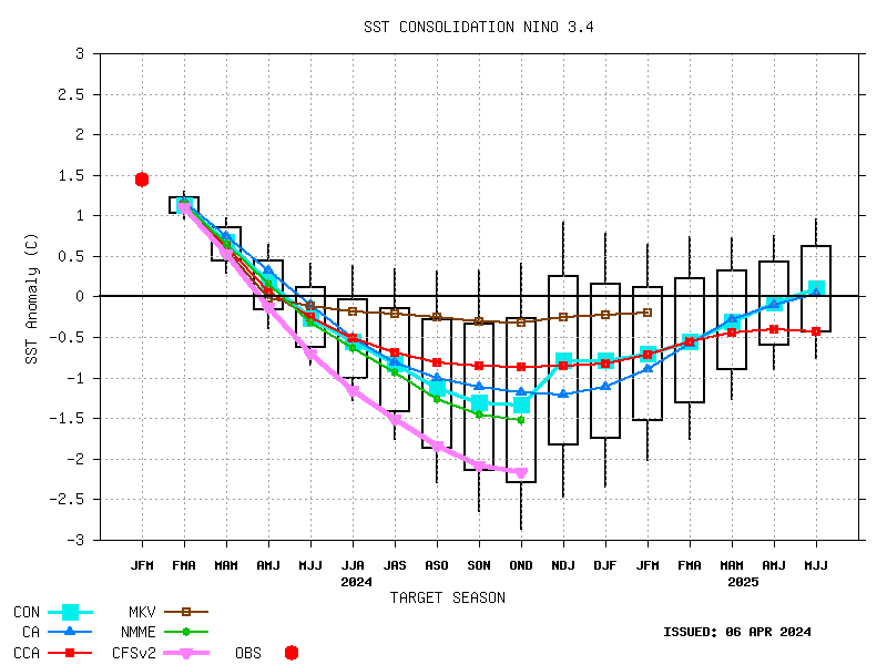
OUTLOOK
CPC presents this experimental seasonal precipitation outlook for the Puerto Rico & US Virgin Islands for May-June-July 2003 through May-June-July 2004. Recent climate anomalies in the central Pacific indicate that the moderate El Nino of 2002 entered its mature phase by December, and is now beginning to weaken. SST anomalies have decreased by more than 2°C in the eastern equatorial Pacific between 130°W and the South American coast (refer to the recent Global SST Anomalies here: Global SST Anomalies). There has also been a steady decrease in the magnitude and extent of the positive subsurface temperature anomalies, indicating a depletion of the excess warmth in the upper ocean of the equatorial Pacific (refer to the recent Subsurface Temperature Anomalies here: Subsurface Temperature Anomalies). A suite of international computer forecasts of El Nino are in general consensus that El Nino conditions in the Pacific basin will slowly weaken in the coming months, e.g., NCEP Coupled Ocean-Atmosphere Model, CPC Canonical Correlation Analysis (CCA) and Constructed Analog (CA). SSTs in the vicinity of Puerto Rico & US Virgin Islands are about 1 Degrees C above normal.
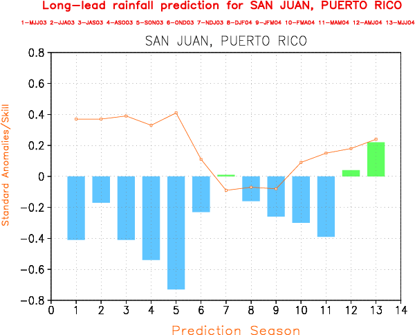
San Juan (Puerto Rico)
Fig 1 shows long-lead precipitation anomaly forecasts, and their expected skills, out to one year into the future for San Juan, Puerto Rico. The bars indicate the forecast values (as standardized anomalies) and the lines indicate the associated skills (as correlation coefficients). Both forecasts and skills use the same ordinate scale. The target season is indicated on the abscissa, ranging from 1 (MJJ 2003) through 13 (MJJ 2004); see the legend at top. It shows a tendency for enhanced probabilities for below normal precipitation for most season especially the Fall of 2003. Above normal precipitation is expected from next Spring (AMJ 2004).
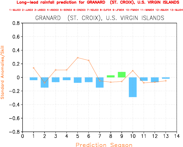
Granard (St. Crox, U.S. Virgin Islands)
Fig 2 shows long-lead precipitation anomaly forecasts, and their expected skills for Granard, St. Crox, U.S. Virgin Islands. The outlook ranges from 1 (MJJ 2003) through 13 (MJJ 2004); see the legend at top. It shows a tendency for enhanced probabilities for below normal precipitation for most season.
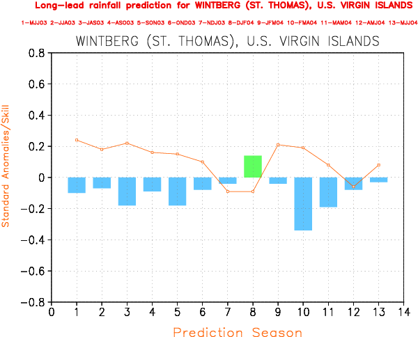
Wintberg (St. Thomas, U.S. Virgin Islands)
Fig 3 shows long-lead precipitation anomaly forecasts, and their expected skills for Wintberg, St. Thomas, U.S. Virgin Islands. The outlook ranges from 1 (MJJ 2003) through 13 (MJJ 2004); see the legend at top. It shows a tendency for enhanced probabilities for below normal precipitation for most season.
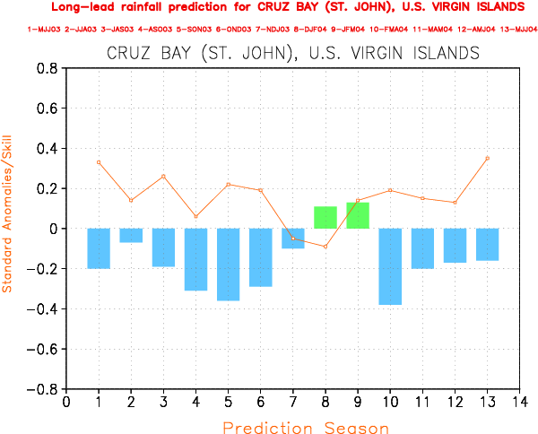
Cruz Bay (St. John, U.S. Virgin Islands)
Fig 4 shows long-lead precipitation anomaly forecasts, and their expected skills for Cruz Bay, St. John, U.S. Virgin Islands. The outlook ranges from 1 (MJJ 2003) through 13 (MJJ 2004); see the legend at top. It shows a tendency for enhanced probabilities for below normal precipitation for most season.
METHOD
(I) Canonical correlation analysis (CCA)
CCA is a statistical method that identifies linear relationships between multicomponent predictors and multicomponent predictands, e.g. pattern-to-pattern relationships in space and/or time. Like simpler forms of linear regression, CCA minimizes squared errors in hindcasting the predictands from the predictors. During the last decade, CCA has started being used increasingly in the atmospheric sciences (e.g. Barnett and Preisendorfer 1987; He 1992; Barnston and Ropelewski 1992; Barnston and He 1996; He and Barston 1996). Here, CCA is used to predict 3-month precipitation anomalies in the Puerto Rico & US Virgin Islands out to a year in advance. The predictor fields used for the forecasts include quasi-global sea surface temperature (SST), Northern Hemisphere 700 mb geopotential height, and the predictand precipitation itself at an earlier time. The set of predictors is configured as four consecutive 3-month periods prior to the time of the forecast, followed by a variable lead time, and then a single 3-month predictand period. The predictand includes 3-month total rainfall stations. The lead time is defined as the time between the end of the final (fourth) predictor period (i.e., the time of the forecast) and the beginning of the 3-month predictand period. The expected skill of the forecasts was estimated using a 1-year-out cross-validation.
(II) Coupled Ocean-Atmosphere Model
The Coupled Ocean-Atmosphere Model is an ensemble mean forecast of a suite of 20 GCM runs forced with tropical Pacific SSts produced by a coupled ocean atmpsphere dynamical model(Ji et al. 1994, Kumar et al. 1996). Its skill has been estimated through the use of 45 years of simulations using the NCEP climate GCM forecd by specified observed SSTs. Its skill depends heavily on ENSO - being almost entirely associated with either cold or warm episodes. The Coupled Ocean-Atmosphere Model forecasts are available only for leads 1 through 4.
REFERENCES
Barnston, A.G. and C.F. Ropelewski, 1992: Prediction of ENSO episodes using canonical correlation analysis. J. Climate, 5, 1316-1345.
Barnston, A.G. and Y. He, 1996: Skill of CCA forecasts of 3-month mean surface climate in Hawaii and Alaska. J. Climate, 9, 2579-2605.
He, Y., 1992: Canonical Correlation Analysis and Long-range Prediction of HawaiianWinter Rainfall, University of Hawaii, UHMET-92-08
He, Y. and A.G. Barnston, 1996: Long-lead forecasts of seasonal precipitation in the tropical Pacific islands using CCA. J. Climate, 9, 2020-2035.
Ji, M., A. Kumar, and A. Leetmaa, 1994: An experimental coupled forecast system at the National Meteorological Center: Some early results. Tellus, 46A, 398- 418.
Kumar, A., M. Hoerling, M. Ji, A. Leetmaa and Sardeshmukh, 1996: Assessing GCM's suitability for making seasonal predictions, J. Climate, 9. 115-129.