|
Synopsis: Weak warm-episode (El Niño) conditions are
expected to continue into early 2005.
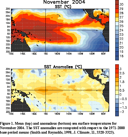
Positive sea surface temperature (SST)
anomalies greater than +0.5°C (~1°F) persisted across most of the central and western equatorial
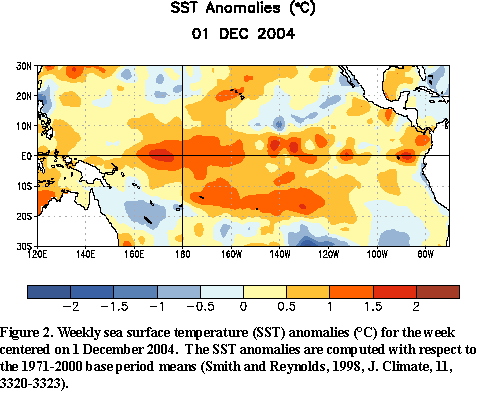
Pacific during November 2004 (Fig. 1). By early December, positive equatorial
SST anomalies greater than +1°C (~2°F) were found from 160°E eastward to 155°W and locally in areas
between 155°W and the South American coast (Fig. 2). The pattern of
anomalous warmth in the equatorial Pacific in recent months and the most
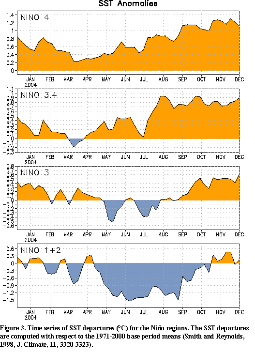
recent 5-month running mean value of the Southern Oscillation Index (-0.6)
indicate that a weak warm (El Niño) episode has developed.
Since late 2003 MJO activity has resulted in
week-to-week and month-to-month variability in many atmospheric and oceanic indices. In the past few months
the warmth in the central equatorial Pacific has supported eastward shifts
of enhanced convection associated with the convectively active phase of the
Madden-Julian Oscillation (MJO) across the western equatorial Pacific. This activity
has been associated with periods of weaker-than-average
easterlies that initiated eastward-propagating oceanic Kelvin waves. This
intraseasonal variability has been superposed on 1) an upward trend in SST
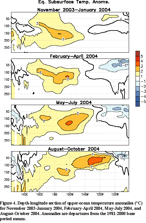
anomalies east of the date line (Fig. 3) and 2) a gradual increase and
eastward shift in the upper-ocean heat content anomalies during the last
year (Fig. 4). Based on the recent
evolution of oceanic and atmospheric conditions and on a majority of the
statistical and coupled model forecasts, it seems most likely that weak warm
episode (El Niño) conditions will persist through early 2005. However, there is
considerable uncertainty concerning future developments in the extreme
eastern equatorial Pacific (the classical El Niño region).
Expected global impacts include drier-than-average conditions over Indonesia
(through early 2005), northern and northeastern Australia (December 2004-February 2005), and
southeastern Africa (December 2004-March 2005). If the warming in the tropical Pacific
strengthens and spreads eastward to the South American coast, then
wetter-than-average conditions would be expected in coastal sections of
Ecuador and northern Peru during the first few months of 2005, and
drier-than-average conditions would be expected to develop in the eastern
Amazon late this year and spread to Northeast Brazil during February through April 2005.
El Niño wintertime impacts over the United States vary considerably depending on
the character (distribution and intensity) of the warming in the tropical Pacific. Composite impacts for
selected ranges of the ONI for El Niño episodes since 1950 (Fig. 5) show that
the spatial extent of warmer-than-average (wetter-than-average) conditions increases across the
northern (southern) United States, as the strength of El Niño increases. The current warming in the
tropical Pacific is expected to continue through the upcoming winter, with models indicating an ONI in the
range of +0.5ºC to +1.2ºC. Thus, the winter outlook for the United States (Fig. 6) is
a blend of the composite impacts for comparable historical El Niño episodes and the effects of long-term
trends. Warmer-than-average conditions are expected in the West and in the northern Plains, while cooler
and wetter-than-average conditions are expected for portions of the South and Southeast.
This discussion is a consolidated effort of NOAA and its
funded institutions. Weekly updates for SST, 850-hPa wind, OLR and features of the equatorial subsurface
thermal structure are available on the Climate Prediction Center web page at
http://www.cpc.ncep.noaa.gov (Weekly Update). Forecasts for the evolution of
El Niño/La Niña are updated monthly in the Forecast
Forum section of CPC's Climate Diagnostics Bulletin. The next ENSO Diagnostics Discussion is scheduled for 6 January 2005. To receive
an e-mail notification when the monthly ENSO Diagnostic Discussions are released, please send
your e-mail address to: ncep.list.enso-update@noaa.gov.
|


