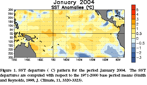
Sea surface temperatures remained warmer than average in
the central and western equatorial Pacific and near average in the eastern
equatorial Pacific during January (Fig. 1). Equatorial ocean surface
temperatures greater than +0.5°C
(~1°F) above
average were found between
Indonesia and 165°W,
and departures greater than +1°C
were found between 160°E
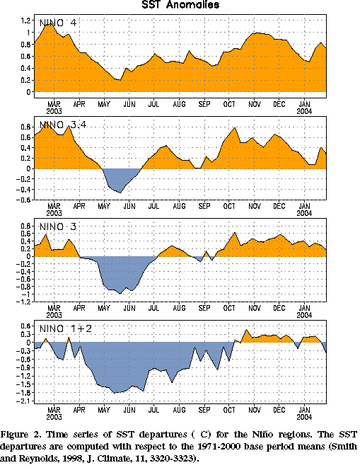
and 175°W. Since early December 2003, SST anomalies have
decreased in all of the Niño
regions (Fig. 2).
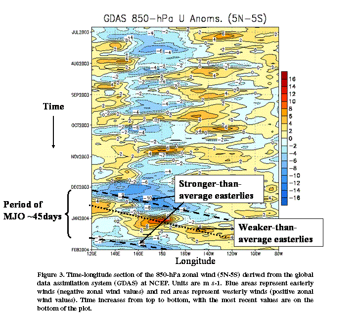
The monthly 850-hPa zonal wind indices, OLR index, 200-hPa zonal wind
index, SOI and EQSOI have not shown any significant trends over the last few
months that would support a transition to either El Niño
or La Niña.
However, many of these indices have exhibited considerable week-to-week
variability since late November in response to tropical intraseasonal
(Madden-Julian Oscillation) activity. Wetter-than-average conditions
(enhanced convection), observed over the tropical Indian Ocean in late
November, shifted eastward to the western Pacific by late December and into
the central Pacific by early January. As the convective activity shifted
eastward, the equatorial easterlies weakened over the western and central
Pacific and westerlies developed near the date line (180°W) (Fig.
3). During the last half of January the equatorial easterlies
intensified, becoming stronger than average over the central and western
equatorial Pacific, as the convectively inactive phase of the MJO shifted
eastward over the region. The recent period (the time that it takes for a
particular phase of the oscillation to completely circle the Earth) of the
MJO is between 45 and 50 days. During late January there were indications
that the convectively active phase of the MJO was over the Indian Ocean. At
the current rate of propagation, enhanced convection should shift into the
western and central equatorial Pacific during February, accompanied by
another period of weaker-than-average easterlies.
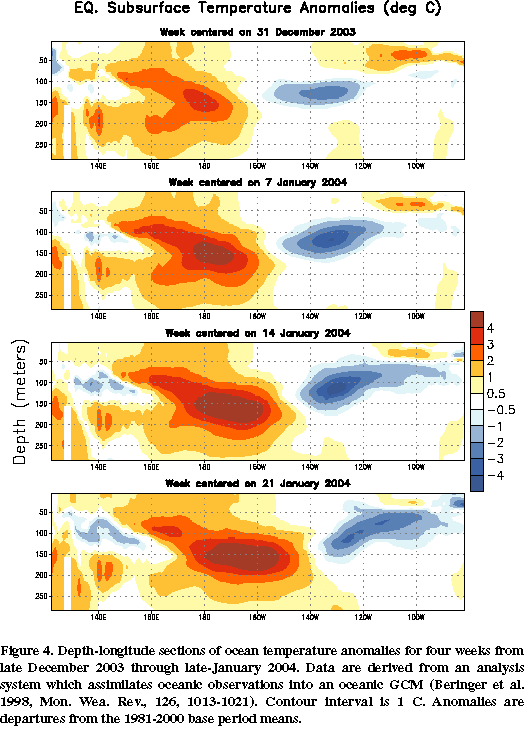
The weakening of the equatorial easterlies in late December 2003-early
January 2004 initiated an eastward propagating oceanic Kelvin wave, which is
evident in the recent evolution of upper ocean temperature anomalies (Fig.
4). More recent observations from the TAO buoy array indicate that this
Kelvin wave is propagating eastward at about 8-10 degrees of longitude per
week. At that rate, the Kelvin wave is expected to reach the vicinity of the
west coast of South America around the end of February. NOAA’s Climate
Prediction Center (CPC) will continue to monitor this situation to determine
what, if any, impacts the Kelvin wave will have on surface and subsurface
temperatures along the South American coast.
A majority of the statistical and coupled model forecasts indicate near
neutral conditions in the tropical Pacific (Niño
3.4 SST anomalies between -0.5°C
and +0.5°C)
through March 2004. Thereafter, the forecasts show increasing spread and
greater uncertainty.
This discussion is a consolidated effort of NOAA and its
funded institutions. Weekly updates for SST, 850-hPa wind, OLR and features of the equatorial subsurface
thermal structure are available on the Climate Prediction Center web page at
http://www.cpc.ncep.noaa.gov (Weekly Update). Forecasts for the evolution of
El Niño/La Niña are updated monthly in the Forecast Forum
section of CPC's Climate Diagnostics Bulletin. To receive
an e-mail notification when the monthly ENSO Diagnostic Discussions are released, please send
your e-mail address to:


