|
| |
|
HOME > Expert Assessments > ENSO Diagnostic Discussion
|
| |
| |
| EL NIÑO/SOUTHERN
OSCILLATION (ENSO)
|
|
DIAGNOSTIC DISCUSSION
|
| issued by |
|
CLIMATE PREDICTION CENTER/NCEP
|
| November 6, 2003 |
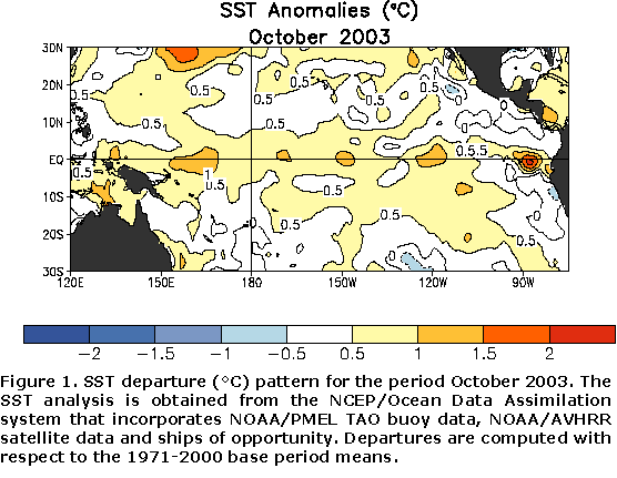
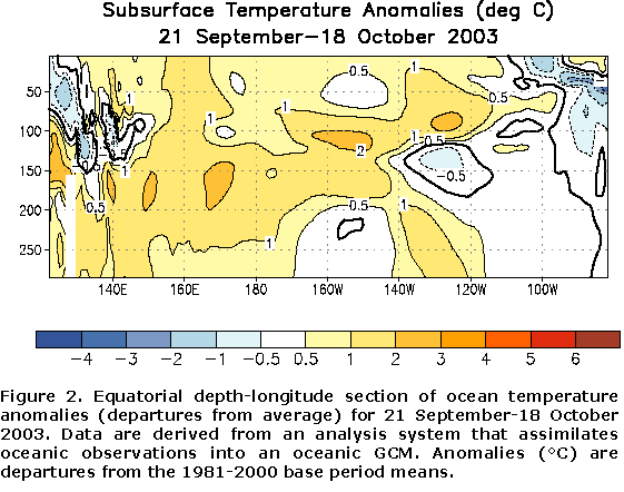
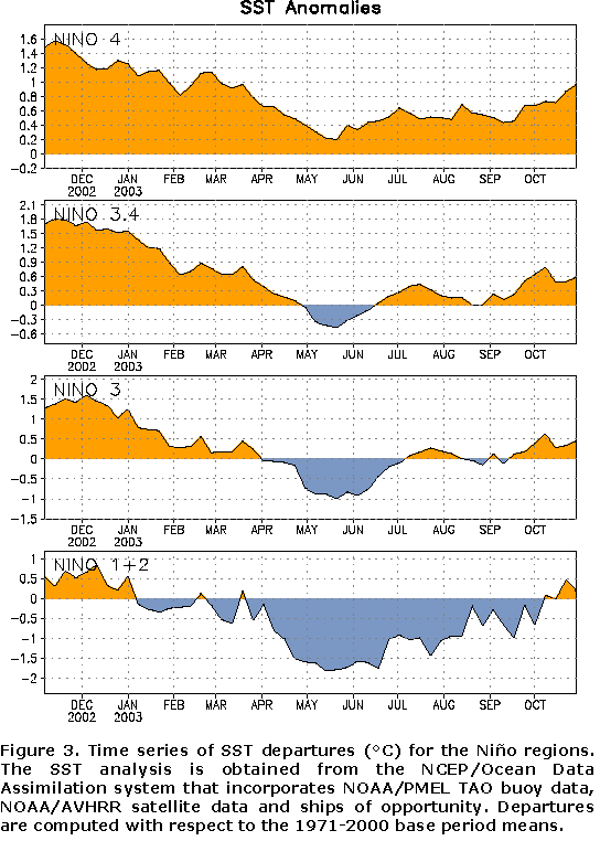
Equatorial surface and subsurface temperatures were warmer
than average throughout most of the Pacific during October (Fig. 1 and
Fig. 2,
respectively). SST anomalies greater than +0.5°C
(~1°F) were
observed in most areas along the equator between Indonesia and the South
American coast. By the end of the month, positive SST anomalies were
observed in all of the Niño
regions (Fig. 3). However, the 850-hPa zonal wind indices (central
and western equatorial Pacific values near zero), OLR index (near zero),
200-hPa zonal wind index (near zero), SOI and EQSOI (near zero) all indicate
ENSO-neutral conditions. These indices do not show any significant trends
that would support either additional large-scale increases or decreases of
SST anomalies in equatorial Pacific.
A majority of the statistical and coupled model forecasts indicate near
neutral conditions (Niño
3.4 SST anomalies between -0.5°C
and +0.5°C) for
the remainder of 2003 and early 2004. However, over the past few months
there has been a trend in the suite of forecasts towards somewhat warmer
conditions, consistent with observed trends in SST anomalies. If the
observed Nino 3.4 SST anomaly for October 2003 (+0.6°C)
persists through November, the three-month (September-November) running mean
value of this index would reach the NOAA threshold (+0.5°C)
for El Niño.
Thus, it is likely that borderline El Niño/
ENSO-neutral conditions will persist in the equatorial Pacific through the
Northern Hemisphere winter of 2003-04. Further evolution of warm-episode
conditions is possible if persistent enhanced equatorial convection
(cloudiness and rainfall) develops in the vicinity of the date line (180°W),
accompanied by weaker-than-average equatorial low-level easterly winds over
the central and western Pacific.
This discussion is a consolidated effort of NOAA and its
funded institutions. Weekly updates for SST, 850-hPa wind, OLR and features of the equatorial subsurface
temperature structure are available on the Climate Prediction Center web page at
http://www.cpc.ncep.noaa.gov (Weekly Update). Forecasts for the evolution of
El Niño/La Niña are updated monthly in CPC's Climate Diagnostics Bulletin Forecast Forum. To receive
an e-mail notification when the monthly ENSO Diagnostic Discussions are released, please send
your e-mail address to:
|
|
|
Climate Prediction Center
National Centers for Environmental Prediction
NOAA/National Weather Service
Camp Springs, MD 20746-4304
e-mail: vernon.kousky@noaa.gov
|
|
|
|


