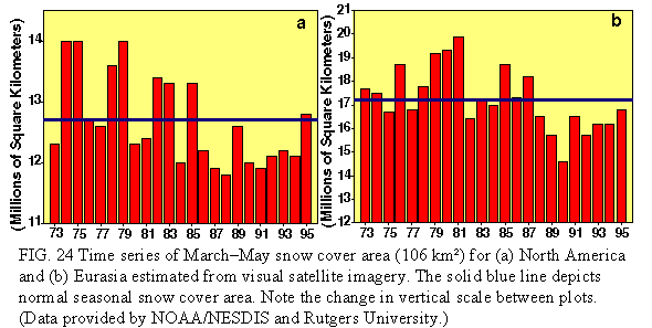
January-May 1995 was one of the warmest first five months on record for large portions of western and central Russia and western Siberia. During this period surface temperatures averaged 3°-8°C above normal throughout these regions (Fig. 50). This abnormal warmth was associated with substantially below-normal snow cover extent over large portions of central and north-central Russia and western Siberia, particularly during the spring period (Fig. 24b). For example, much of this region normally experiences 20-25 days of snow cover during April. However, according to snow observations derived from the special sensor microwave imager (SSM/I) (Grody and Basist 1995), these areas recorded less than 5 days of snow cover (Fig. 51 ) during April 1995, as mean temperatures averaged 8°-10°C above normal.
These conditions were linked to an extremely anomalous atmospheric circulation pattern (Fig. 52) that persisted from mid-January through the end of May. Prominent features of this pattern included below-normal heights over the northern and northeastern North Atlantic (Fig. 52a), and above-normal heights throughout western and northwestern Russia. This overall pattern reflected a pronounced negative phase of the East Atlantic/ Western Russia (EATL/WRUS) teleconnection pattern (Bell and Halpert 1995), also referred to as the Eurasia-2 pattern by Barnston and Livezey (1987). This pattern is one of two prominent modes that affects Eurasia during most of the year. This pattern exhibits considerable month-to-month variability and rarely persists in a strong positive or negative phase (normalized magnitude greater than 1.0) for more than two consecutive months. During January-May 1995 the EATL/WRUS normalized pattern index was below -1.0 for five consecutive months for the first time in the record dating to 1964.
During January-May 1995, this anomalous circulation was associated with a marked intensification of the mean westerly flow over the eastern North Atlantic and Europe (Fig. 52 b), and with mean southwesterly flow over much of eastern Europe, western Russia, and western Siberia. These conditions supported a sustained flow of relatively warm air throughout western Asia and Europe during the period, resulting in abnormally warm conditions in these areas. This pattern was also associated with significantly above-normal rainfall over large portions of western and central Europe during January and February, resulting in large-scale and severe flooding.
In strong contrast to the early part of the year, the November-December 1995 period featured a persistent pattern of above-normal heights over the northern North Atlantic and below- normal heights throughout north-central Russia and western Siberia. This pattern was associated with mean northwesterly flow throughout Scandinavia and western Eurasia, resulting in below-normal surface temperatures and enhanced snow coverage during the period.
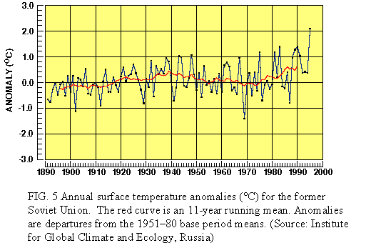
For 1995 as a whole, most of Russia reported annual mean temperatures among the warmest 10% of the 1961-90 distribution, with annual temperatures averaging 2°-4°C above normal at many locations. With respect to the countries which formerly comprised the Soviet Union, 1995 was the warmest year since records began in 1891, with an average temperature of 2.1°C above normal (Fig. 5). This value far surpasses the previous record warm year of 1990, in which mean annual temperatures averaged 1.4°C above normal.
Abnormally hot and dry conditions dominated many areas of Europe and western Russia during June-August (JJA) 1995, a reprise of the extremely warm conditions observed during the previous summer in many locations. Conditions were particularly acute across the British Isles, where JJA rainfall totals averaged less than 100 mm in most areas. Unofficial statistics indicate that Great Britain may have endured its driest summer in more than 3 centuries. Additionally, central England experienced its warmest August on record dating back to 1659 and its warmest July - August period since 1750 (Fig. 53).
A monthly analysis of surface temperature anomalies during June-August (Fig. 54) indicates that the abnormally warm conditions during June (Fig. 54a) were found primarily over western Russia, a continuation of abnormally warm conditions that dominated western Eurasia during January-May 1995 (discussed above). During July (Fig. 54b) the region of abnormally warm conditions moved westward and became centered over northern and northeastern Europe, and by August the region of anomalous warmth was centered over the British Isles (Fig. 54c). The abnormal conditions over Eurasia during JJA were related to an anomalous circulation regime (Fig. 55), characterized by a retrogressing pattern of above normal heights that moved from western Russia in June to the eastern North Atlantic by August. This pattern was associated with an overall anomalous northward shift of the main storm track during the period, as well as with a substantially reduced flow of marine air into large portions of central and northern Europe.
Overall, the 1995 Indian monsoon season (June-September) featured near-normal rainfall over large portions of India, and substantially above-normal rainfall throughout Bangladesh, Burma, far eastern India, and large portions of Thailand. The heaviest precipitation (1500-2000 mm) was observed in the east (Fig. 56a), where totals averaged more than 300 mm above normal during the season (Fig. 56b). Above normal rainfall was also observed in the north, where totals averaged 750-1000 mm during the season (100-300 mm above normal), and in the southeast, where totals averaged 500-750 mm (100-200 mm above normal). Elsewhere, more than 1000 mm of rain fell throughout Bangladesh and Burma during the 1995 monsoon season, with totals in north-central Burma exceeding 200-250 mm above normal and totals in northeastern Bangladesh exceeding 300 mm above normal. In southern Thailand, rainfall totals averaged 2000-2500 mm (more than 300 mm above normal) during the season.
The 1995 monsoon season was preceded during the first three weeks of June by exceptionally hot weather throughout India. During this period, temperatures averaged in excess of 38°C (100°F) throughout much of central and northern India (Fig. 57) and averaged more than 43°C (108 °F) in portions of the north and northeast. This marks the second consecutive year in which a brutal heat wave prior to the summer monsoon took hundreds of lives across the Indian subcontinent. During 1995 the onset of the monsoonal rains was delayed, beginning in late June. These rains remained generally below normal in intensity over much of India until mid-July. A sharp increase in rainfall was then observed across the Indian subcontinent in mid-July, and these heavy rains persisted through August and much of September. These rains resulted in flooding along many rivers and in numerous towns, particularly in Pakistan, Bangladesh, and southern Thailand.