Northern and northeastern Australia
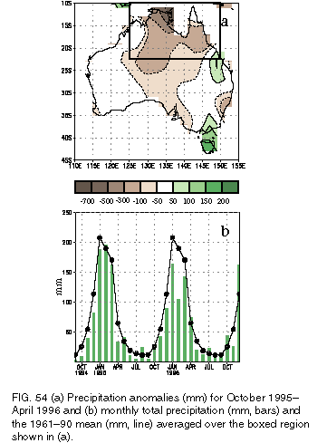
Northern and northeastern Australia (indicated by the boxed area in Fig. 54a) experience a well-defined rainy season that typically begins in October and ends in April. Much of the area receives more than 75% of its mean annual precipitation (with portions of extreme northern Australia recording more than 90%) during this 7-month period (Fig. 54b ). This annual cycle is strongly modulated by the Southern Oscillation, with below- (above-) normal rainfall typically observed during Pacific warm (cold) episodes (Ropelewski and Halpert 1987, 1989). Overall, precipitation during the 1995/96 wet season averaged below normal throughout the region, with large deficits observed in all months except October and April (Fig. 54b). The largest deficits were recorded in extreme northeastern Arnhem Land, where totals were more than 700 mm below normal for the entire season (Fig. 54a). Elsewhere, totals averaged 100-300 mm below normal, with the exception of the southeast portion of the region where they averaged 50-100 mm. Last year, rainfall totals averaged 200-500 mm above normal across north-central Australia, including a record amount of 2384 mm at Darwin, and 200-400 mm below-normal in the northeast (not shown).
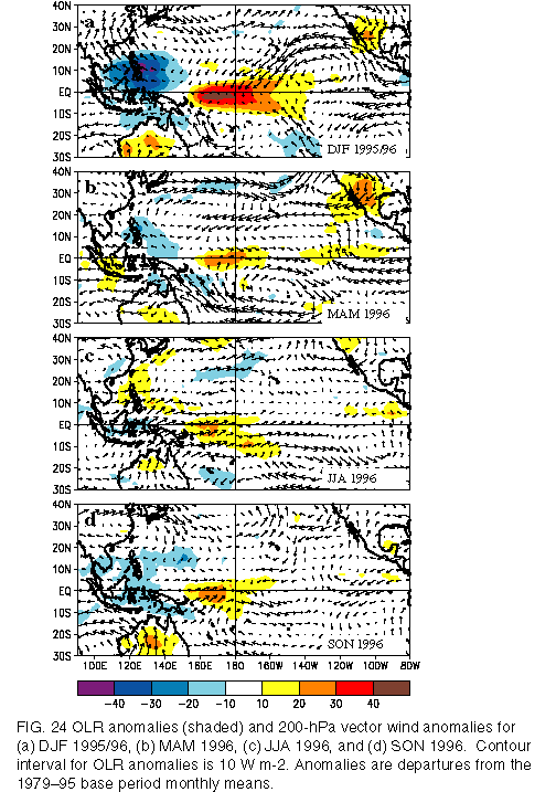
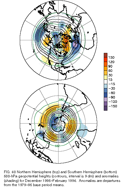
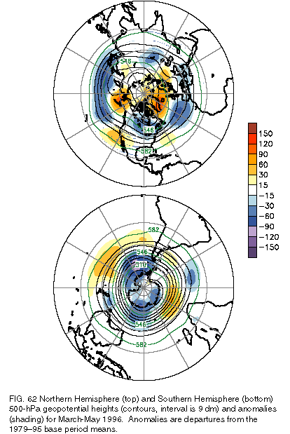
The reduced precipitation during the 1995/96 wet season reflected a weaker-than-normal Australian monsoon system, and contrasts with the enhanced rainfall typically expected during Pacific cold episodes. There appears to be two primary reasons for this reduced rainfall: 1) a pronounced shift in the area of maximum convection to north of the equator during this cold episode, particularly during December-February (Fig. 24a); and 2) a persistent and amplified upper-level trough over extratropical eastern Australia (Figs. 60 and 62 ). This feature affected the large-scale atmospheric circulation well into the subtropics, and contributed to anomalous upper-level convergence and descending motion across central and north-central Australia.
Eastern Australia
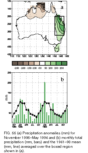
Rainfall totals in eastern Australia (indicated by the boxed area in Fig. 55a) are largest during the warm season between November and May, with the annual peak observed during January-March (Fig. 55b). This region also exhibits a strong ENSO signal, with suppressed (enhanced) rainfall often occurring during Pacific warm (cold) episodes (Ropelewski and Halpert 1987, 1989). During the November 1995- May 1996 season, area-averaged rainfall totals were largest in the 3-month period November 1995-January 1996, with much of the eastern and northeastern parts of the region recording anomalies greater than 150 mm, and the western and southwestern areas recording surpluses of 50-100 mm (Fig. 55a). The heaviest precipitation fell in January, when areaaveraged totals (197 mm) nearly doubled the climatological mean (105 mm). This heavy precipitation was associated with Tropical Cyclone Barry during 1-9 January and with several storm systems later in the month. The rainfall contributed significantly to a further easing of drought conditions that developed across the region during much of 1994 and 1995. Below-normal rainfall totals returned to the region during February and March 1996, followed by normal to above-normal rainfall during the remainder of the year (Fig. 55b ).
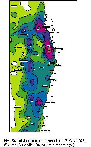
According to the Australian Climate Analysis Center Annual Climate Summary for 1996 (Australian Bureau of Meteorology 1997), "the most dramatic event of the year occurred over southeast Queensland and northern New South Wales during the first week of May" (Fig. 56), "in association with a moist onshore airstream and a sharp, slow-moving upper level trough." These features brought "torrential rains to the region, with many monthly and daily records broken during the first week." Numerous stations in the area received 250-500 mm, while stations in orographically-favored locations received in excess of 1000 mm. The largest totals were observed at Natural Bridge (1808 mm), Springbrook (1600 mm), Mt. Tamborine (1161 mm), Mt. Glorious (1053 mm), Doon Doon (1030 mm), Commissioners Creek (980 mm), and Mt. Nebo (931 mm). These totals, which in some cases were more than double the previous record rainfall for the entire month, resulted in severe flooding in southeastern Queensland. Brisbane, the capital city, recorded 606 mm during this period, surpassing the previous May record by over 200 mm. This rainfall led to the most severe flooding since January 1974 and ironically occurred in an area that had experienced severe drought during the past 5 years.
Southeast and Tasmania
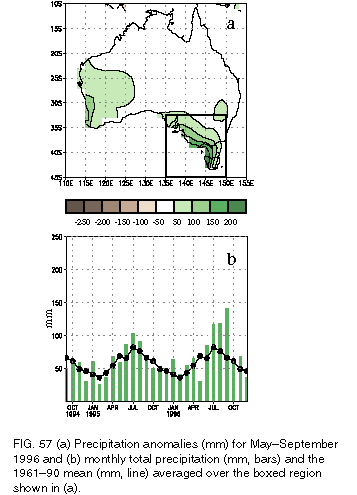
Rainfall totals in southeastern Australia (indicated by the boxed area in Fig. 57a) are largest during the cool season between May and September, with the annual peak observed in July and August (Fig. 57b). During 1996, below-normal rainfall was observed in May and above-normal precipitation fell during June-September. During this latter period, accumulated totals averaged 50-200 mm above normal, with the largest positive anomalies observed in extreme southern Victoria and western Tasmania (Fig. 57a). These exceptionally heavy rains led to flooding of the Murray River during late September/early October.
For the year as a whole, rainfall was below-normal in this region in only two months: May and December. In fact, January-September was one of the wettest periods on record for the region, with Melbourne recording its highest period totals since 1911. Many local rainfall records were also set in southern and western Tasmania during January-April.
New Zealand
Overall, 1996 was abnormally wet and stormy over the North Island and drier than normal on the South Island. There were two primary episodes of very heavy rainfall during the year, which led to "flash flooding." The first occurred during the last week of January in Gisborne, which received 80 mm of rain during the week, but with much larger totals at higher elevations. The same storm produced 362 mm of rain in 48 hr at Raoul Island, the highest 2-day total there since records began in 1937. Gisborne then received another severe rainfall and flooding event on 30-31 March from Extratropical Cyclone Beti, with 164 mm of rain measured in Gisborne and over 300 mm measured at higher elevations during the 2-day period. Another flooding episode occurred during 7-8 February in both South Canterbury and Wellington, with the former region receiving more than 300 mm of rain during the 2-day period.
Overall, mean annual temperatures in Australia during 1996 were the fifth warmest on record dating back to 1910, averaging 0.65oC above the 1961-90 mean. This warmth was not uniform across the continent, with the largest positive temperature anomalies occurring across the subtropics during June-August and the largest negative anomalies occurring in the southeast throughout most of the year. There were at least two notable warm periods during the year over Australia. The first was a major heat wave in the Southwest during 1-20 February 1996. During this event, Perth recorded a record 16 consecutive days with temperatures exceeding 32oC. The second was an abnormally warm June over inland Australia, particularly in the center of the continent where many locations recorded their highest mean temperatures on record for the month. During this period, extensive areas recorded temperatures 3°-6oC above normal.