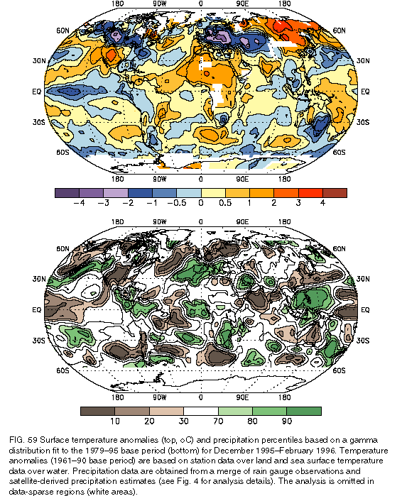
The 1995/96 winter (DJF) season featured abnormally cold and snowy conditions in the northern plains, the eastern half of the Midwest, the Northeast, the mid-Atlantic states, and much of Canada. For the season as whole, temperatures averaged 3°-5oC below normal across western and central Canada, and 1°-2oC below normal across the northern tier of the United States and throughout the eastern seaboard from Florida to New England (see section 5, Fig. 59a ). In the East, these conditions contrasted with the abnormally warm temperatures and low snowfall totals (less than 25% of normal) observed during the 1994/95 winter.
One prominent aspect of the 1995/96 winter season was a recurring pattern of enhanced northwesterly flow, which extended from northern Alaska and the Bering Sea to southeastern Canada and the north-central United States. This flow brought a series of major winter storms and severe winter outbreaks to the northern and eastern United States, resulting in record-breaking cold and snowfall totals in many regions. The season also featured considerable variability over large portions of the United States and Canada, with periods of extreme cold and snow followed by brief periods of warmth and rain.
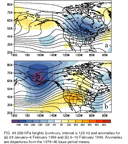
The most notable cold-air outbreak occurred during 29 January-6 February 1996, when temperatures averaged 11°-17oC below normal from the southern Canadian prairies southeastward through the northern and central plains and western Great Lakes and more than 6oC below normal throughout the rest of the United States with the exception of the Southwest. Temperatures dropped below -40oC throughout interior Canada during the period and below -46oC in some portions of central Canada. In the United States, all-time record low temperatures were set in four states (Minnesota, Iowa, Illinois, and Rhode Island), and nearly 400 daily record lows were either tied or broken. Additionally, the cold temperatures were accompanied by strong winds that produced extreme wind chill temperatures below -50oC over much of Canada and large portions of the northern United States. The upper-level height and anomaly fields (Fig. 48a) reveal that the Arctic outbreak was associated with a highly amplified flow, featuring above-normal heights across the high latitudes of the central North Pacific and well below normal heights throughout central North America. Within this flow pattern, height contours originating in Alaska, eastern Siberia, and the Arctic Circle covered central and southern Canada and extended southeastward across the upper one-third of the United States east of the Rocky Mountains. This pattern resulted in a sustained flow of pure Arctic air into central and eastern North America.
This Arctic outbreak was immediately followed during 6-10 February by much milder air across central North America. During this 5-day period, temperatures reached 21oC in the plains states, more than a 50oC increase from the record-low readings observed the prior week. At Tulsa, Oklahoma, new February extreme minimum (-24oC) and maximum (32.2oC) records were set within 18 days of each other in association with the Arctic outbreak and subsequent warm-up. This warm-up was associated with a large-scale transition in the upper-level flow to below-normal heights and a deep trough over western Alaska and an amplified ridge over the intermountain region of North America (Fig. 48b). This pattern resulted in a strong and extensive flow of marine air from the central North Pacific into virtually all of North America.
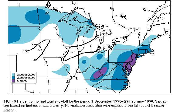
Overall, snowfall totals by the end of February averaged more than 150% of normal over the Dakotas and the upper Midwest and over the central and eastern United States from Indiana northeastward to southeastern Maine and southeastward to the Virginia coast (Fig. 49). Totals exceeded 200% of normal from southern Virginia northward to northern Massachusetts, and more than 300% of normal snowfall was recorded from central Maryland northward to southern New York and throughout the southern Appalachian Mountains region. Totals also averaged 200%-300% of normal over eastern North Dakota, northwestern Minnesota, and western South Dakota.
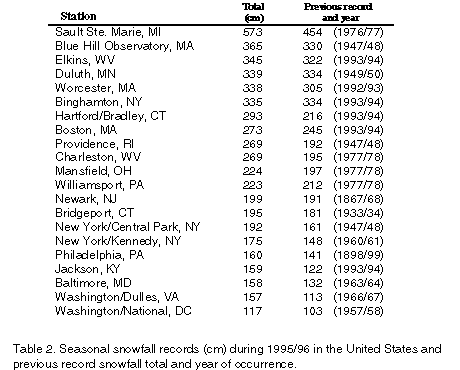
Many locations established new all-time record seasonal snowfall totals during the 1995/96 cold season (Table 2). The largest total snowfall (573 cm) was observed at Sault Saint Marie, Michigan, which broke its previous highest total snowfall accumulation record of 454 cm. Most of the other records were established in the East, extending from Virginia in the south to Massachusetts in the Northeast. For many of these cities, the previous snowfall records were broken by mid-February. In some locations the previous record snowfall totals were exceeded by more than 60 cm during the winter of 1995/96.
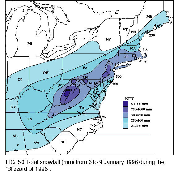
Perhaps the most notable snow event during the winter was the blizzard of 6-9 January 1996, which
af
fected the entire eastern United States. During this event, 50-120 cm of snow covered the eastern
seaboard from the mid-Ohio valley eastward to eastern Virginia and northward to southern Massachusetts (Fig. 50). Totals exceeded 76 cm at Philadelphia, Pennsylvania, establishing a new single-storm record, and
reached 87.5 cm in west-central New Jersey and 120 cm in Pocahantas County, West Virginia. Additionally,
most areas from Washington, D.C., northeastward to Providence, Rhode Island, reported one of the five
biggest single-storm snowfall totals on record during the storm, which resulted in a shutdown of most airports on
the East Coast from Virginia northward and made other modes of transportation virtually impossible.
In contrast, during the following week the eastern United States experienced a dramatic warm-up and heavy rains (50-150 mm), resulting in a rapid snow melt and extensive runoff. These conditions produced flooding throughout the mid-Atlantic States and the Northeast during 19-24 January. During this period, all major rivers in Pennsylvania, Ohio, West Virginia, Virginia, Maryland, New York, and Vermont crested 1.2 m-3.6 m above flood stage. In many areas, this was the highest recorded crest since the flooding associated with Hurricane Agnes in June 1972.