c. Asia
The Indian summer monsoon typically lasts from June through September. During this period large areas of western and central India receive more than 90% of their total annual rainfall, while southern and northwestern India receive 50%-75% of their total annual rainfall. Overall, monthly rainfall totals average 200-300 mm, with the largest values observed during the heart of the monsoon season in July and August.
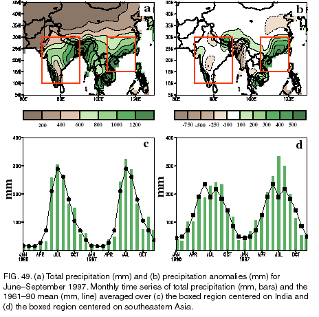
According to the India Meteorological Department there was a slightly delayed onset to the 1997 monsoon season, with heavy rains beginning approximately one week later than normal. However, the monsoon covered most of the country by 19 July, only four days later than normal. This delay contrasts with conditions observed during 1996, when the monsoon rains covered India by 30 June, two weeks earlier than normal. Overall, area-averaged rainfall was slightly above normal during June-August (Fig. 49c), and slightly below-normal in September.
Regionally, the 1997 season featured abundant rains (1200-1600 mm) in the typically heavy rainfall area of western India (Figs. 49a ), which is 200-600 mm above the long-term mean (Fig. 49b). Elsewhere, rainfall was near normal over most of India, with below-normal totals confined to portions of the central and north-central sections. In northern India, beneficial rains were sometimes associated with strong midlatitude westerly disturbances moving across the region. These rains brought totals to near normal for the season as a whole, despite a weaker-than-normal and highly variable monsoon circulation during much of the period.
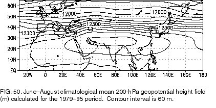
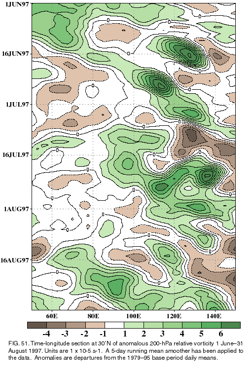
An extremely important component of the monsoon circulation is the upper-level (200-hPa) monsoon ridge, which normally extends from the Middle East eastward to southeastern Asia at approximately 27.5°N (Fig. 50). This monsoon ridge normally develops during June and reaches full strength in July and August. Accompanying this evolution is a pronounced shift of the midlatitude westerly winds from south to north of the Tibetan Plateau by mid-June. During 1997 the anomalous monsoon circulation was apparent in both the upper-level monsoon ridge and the midlatitude westerlies (not shown), which exhibited substantial daily and weekly variability in their location and magnitude. This variability is summarized using a daily time-longitude section of upper-level relative vorticity centered on 30°N (Fig. 51).
In this analysis, large cyclonic relative vorticity anomalies over northern India indicate a weakening of the monsoon ridge, along with a southward shift of the mean westerly winds and strong westerly disturbances. The 1997 season featured several prolonged periods in which anomalous cyclonic relative vorticity prevailed over northern India (approximately 70°-90°E), including the June through mid-July period when these conditions were evident nearly 50% of the time. During this period, there was a substantial impact on the northern part of the monsoon region from midlatitude westerly disturbances.
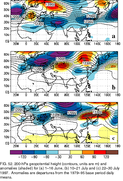
A more detailed analysis for the period indicates that during the first two weeks of June the monsoon ridge was displaced far southeastward from normal and was nearly absent across northern India (Fig. 52a). Large-scale midlatitude troughs were located along the western and eastern flanks of the ridge, with strong westerly geostrophic winds found across northern India and most of southern Asia. Thus, much of subtropical Asia was affected by extratropical flow features during this period.
During mid-July, there was a marked retraction in the eastward extent of the monsoon ridge, as well as a westward shift of the mean ridge axis to the area just south of the Caspian Sea (Fig. 52b). This highly anomalous monsoon ridge was associated with a large-amplitude wave pattern extending from the Middle East to eastern Asia.
During late July the monsoon ridge became better defined across India (Fig. 52c), but remained ill-defined across southeastern Asia. This flow pattern also suggested a continued substantial impact from extratropical disturbances on the large-scale monsoon circulation. These conditions finally lessened during August as the monsoon ridge became better defined.
Rainfall across southeastern Asia is also monsoonal in nature, with the largest totals typically observed
during May-September (Fig. 49d
). Area-average totals normally reach 200 mm in each of these months, with
seasonal totals of 1000 mm commonly observed. During 1997, seasonal rainfall totals averaged 1300-1500
mm throughout the region (not shown). Most of this enhanced rainfall occurred during June-August, with
area-
averaged totals reaching 250 mm in June and 300 mm in July and August. In Hong Kong, monthly rainfall
totals reached 700 mm during June, July and August, with the three-month total exceeding 2400 mm. This value
is more the 2.2 times the average rainfall expected in that region for the period.
During June and July, the very large rainfall totals across southeastern Asia were related to an increased frequency of westerly wave disturbances, in association with the much weaker-than-average upper-level monsoon ridge (Figs. 51, 52). For example, during 1-16 June when the monsoon ridge was extremely suppressed (Fig. 52a), Hong Kong received over 600 mm of rain compared to a mean of 200 mm. Similarly during 10-21 July when the subtropical ridge axis was retracted to west of India (Fig. 52b), Hong Kong received almost 400 mm of rain compared to a mean of just over 100 mm. Subsequently, rainfall was below average at Hong Kong during 22-30 July as the subtropical ridge extended eastward across southeastern Asia (Fig. 52c).
During August, above-normal rainfall continued across southeastern Asia, primarily in response to five tropical cyclones that moved across the region. Four of these systems affected southeastern China and one affected extreme southern China near Hong Kong. These systems brought flooding to much of the area, particularly in coastal southeastern China.