3. The strong 1997-98 El Nińo and transition to a La Nińa episode
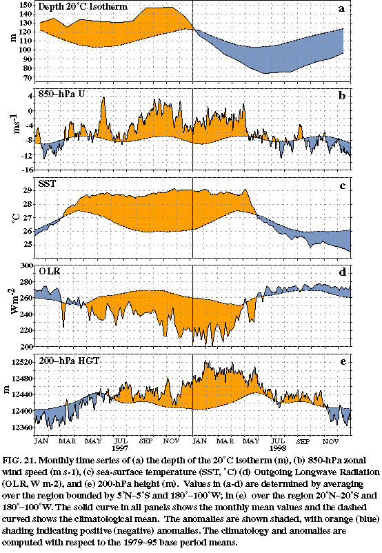
The global climate during 1998 was affected by both extremes of the ENSO cycle (Fig. 21), with one of the strongest El Nińo episodes in the historical record continuing during January-early May and La Nińa conditions occurring from July through the remainder of the year. Across the eastern Pacific these ENSO extremes were evident in the time series of subsurface temperature anomalies (Fig. 21a), low-level (850 hPa) equatorial easterly wind anomalies (Fig. 21b), SST anomalies (Fig. 21c), anomalous tropical convective activity, as measured by anomalies of outgoing longwave radiation (OLR) (Fig. 21d ) and upper-level (200 hPa) height anomalies (Fig. 21e).
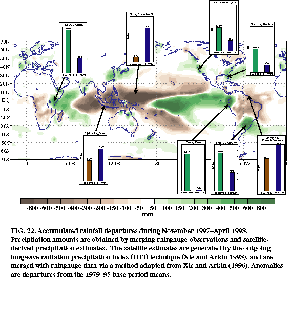
From January through May 1998 strong warm episode conditions contributed to major regional rainfall (Fig. 22) and temperature anomalies over large portions of the Tropics and extratropics, which are generally consistent with those observed during past warm episodes (Ropelewski and Halpert 1987, 1989; and Halpert and Ropelewski 1992). El Nińo impacts during the period included 1) a continuation of severe drought in Indonesia, 2) a continuation of strong convection and increased rainfall across the eastern half of the tropical Pacific (Figs. 21d, 22 ), 3) flooding, mudslides, and extremely heavy rainfall in Peru, 4) a continuation into February of the rainy season and strong convective activity across equatorial eastern Africa, 5) below-normal rainfall and forest fires in the Amazon basin, 6) increased storminess and rainfall over southeastern South America, 7) a wet and stormy 1997/98 winter season across the southern tier of the United States and California, 8) an extremely mild 1997/98 winter and spring season across North America, with record temperatures observed over portions of Canada and the United States, 9) extensive dryness and wildfires in Mexico during March-May, 10) record heat and drought across the south-central United States during April-June [see section 4a(2)], and 11) persistent dryness over the Hawaiian Islands.
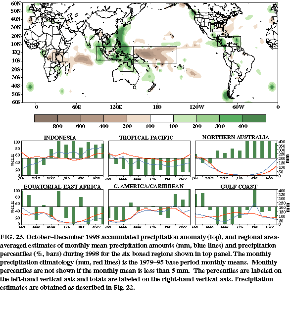
Cold episode conditions during the second half of the year also impacted global temperature and precipitation patterns in a manner consistent with past cold episodes (Ropelewski and Halpert 1989; Halpert and Ropelewski 1992). These impacts included 1) above-normal rainfall across Indonesia (Fig. 23); 2) a nearly complete disappearance of rainfall across the east-central equatorial Pacific; 3) a weakening and westward retraction of the wintertime jet stream across the South Pacific during July-September (see section 3d); 4) above-normal tropical storm and hurricane activity across the North Atlantic during August-November [see section 4a(1)]; 5) reduced rainfall across equatorial eastern Africa during the peak of the region's rainy season (October-December) and 6) above-normal rainfall across Central America and the Caribbean Sea during October-December.
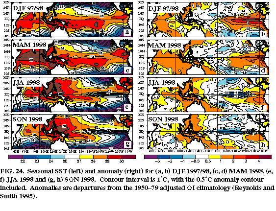
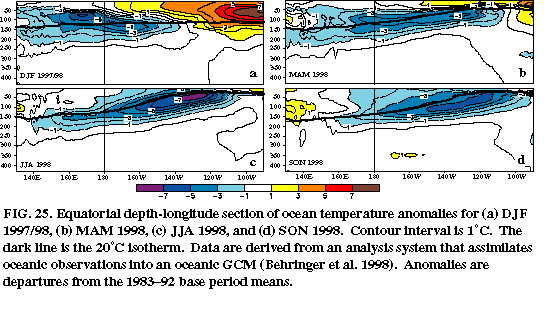
The 1997-98 El Nińo episode featured extremely warm (greater than 28°C) sea surface temperatures (SSTs) across the eastern half of the tropical Pacific from May 1997-early May 1998 (Fig. 21c). These conditions reflected a complete disappearance of the mean annual cycle in SSTs in this region, along with a disappearance of the equatorial "cold tongue" which normally extends westward from South America to the date line (Figs. 24a, c ). The largest SST anomalies over the eastern half of the equatorial Pacific occurred during September-December 1997 (Fig. 21c), which coincides with the time of year in which SSTs are normally coldest and the equatorial cold tongue is best defined.
Smaller, yet substantial, anomalies were recorded during January-April 1998, which coincides with the time of year in which the climatological mean temperatures increase and the equatorial cold tongue becomes progressively less pronounced. Despite the decrease in SST anomalies across the eastern half of the Pacific during this period, the actual SSTs remained nearly constant. Therefore, the apparent "evolution" indicated by the anomaly field (which was also observed during the same period in the 1982-83 El Nińo) primarily reflected the climatological mean annual cycle in SSTs and not a notable weakening of the El Nińo phenomenon. Indeed, the mean and anomalous SST fields during DJF 1997/98 (Figs. 24a, b) and MAM 1998 (Figs. 24c, d) clearly indicate the continuation of extremely strong El Nińo conditions throughout the period. This observation highlights the ambiguity inherent in assessing the relative strength of a warm episode and its forcing of the atmospheric circulation based solely on the SST anomalies.
During DJF 1997/98 the anomalously warm ocean waters in the central equatorial Pacific extended down to approximately 70 m depth (Fig. 25a ), and overlaid anomalously cold ocean waters at approximately 150 m depth which resulted in an enhanced thermal contrast in the thermocline in that region (see also Bell and Halpert 1998, their Fig. 25d). Farther east, the abnormally warm ocean waters (exceeding 7°C above normal at 50-100 m depth) extended to more than 150 m depth in association with increased depths of the oceanic thermocline. Overall, these conditions reflected a flat thermocline structure and a disappearance of the normal east-west temperature gradient across the entire equatorial Pacific.
During MAM 1998 shoaling of the oceanic thermocline reflected a decrease in the volume of warm water in the eastern half of the Pacific, and a confinement of the region of positive temperature anomalies to the upper ocean (Fig. 25b ). These conditions were accompanied by an increased slope of the thermocline and an increased subsurface temperature gradient across the equatorial Pacific. This subsurface structure set the stage for a rapid transition to below-normal SSTs in the east-central equatorial Pacific, which subsequently began during the first week in May. At that time the low-level equatorial easterly winds returned (Fig. 21b) and were associated with enhanced upwelling bringing cooler ocean waters to the surface throughout the east-central equatorial Pacific (Figs. 21c, 25c).
Throughout the 1997-98 El Nińo, atmospheric convection and rainfall were enhanced across the eastern half of the tropical Pacific (Fig. 22) and monsoonal precipitation was suppressed across Indonesia and the western tropical Pacific. The combined zonal extent of these anomalies spanned a distance more than one-half the circumference of the earth.
Within the Indonesia sector, a nearly complete lack of tropical rainfall in portions of Sumatra and Borneo from mid-July 1997 through early September 1997, followed by substantially below-normal rainfall during the next three months, contributed to extensive wildfires and an ecological disaster (Bell and Halpert 1998). These fires were started by dry-season burning which takes place each year to clear land for planting crops.
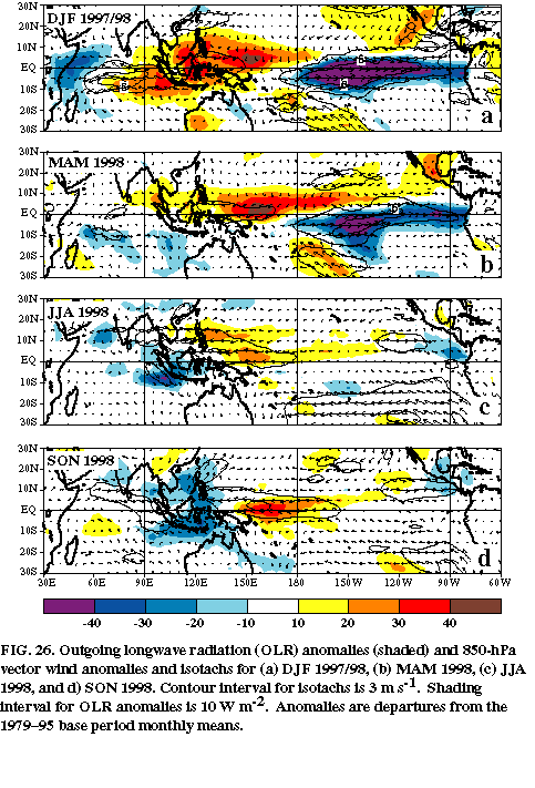
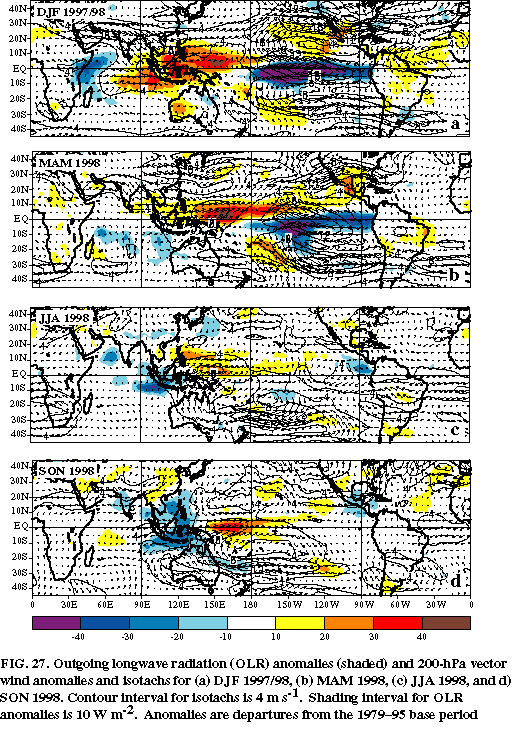
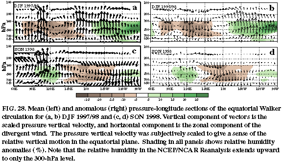
During DJF 1997/98 and MAM 1998 the anomalous convective activity was accompanied by an almost complete absence of the normal low-level (850 hPa) equatorial easterly winds across the eastern half of the Pacific (Fig. 21b), as indicated by strong westerly wind anomalies throughout the region (Figs. 26a, b). The anomalous tropical convection was also accompanied by a collapse of the westerly winds normally observed at upper levels (200 hPa) across the eastern equatorial Pacific, as indicated by anomalous easterly flow exceeding 10 m s-1 throughout the region (Figs. 27a, b). The combined patterns of vertical motion and atmospheric winds and anomalies (Figs. 28a, b) are consistent with a complete disappearance of the normal equatorial Walker Circulation during the period. Similar conditions were noted during the previous two seasons by Bell and Halpert (1998, see their Fig. 28).
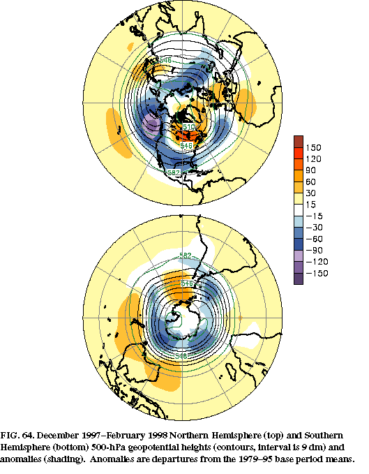
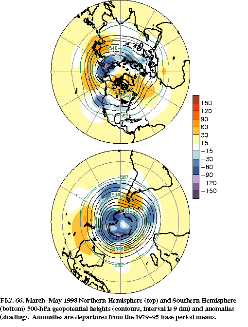
Other major rainfall systems were also affected by the strong El Nińo conditions, including a weakening of the South American/ Central American monsoon and a shift of heavy rainfall typical of interior equatorial Africa toward eastern equatorial Africa and the western Indian Ocean. Overall, these shifts in rainfall patterns represented a more zonally-uniform distribution of rainfall and deep tropospheric heating throughout the global Tropics and subtropics than is evident in the climatological mean. This shift in the heating patterns imparted a substantial forcing onto the atmospheric circulation of both hemispheres by contributing to increased heights (Fig. 21e) and temperatures across the eastern tropical Pacific and ultimately throughout the global Tropics and subtropics (see section 5, Figs. 64, 66).
As a reflection of these increased heights and temperatures, pronounced upper-level anticyclonic circulation anomalies during both DJF 1997/98 and MAM 1998 covered the subtropical eastern Pacific in both hemispheres (Figs. 27a, b ). This anomaly dipole flanked the region of enhanced tropical convection and was linked directly to the strong El Nińo conditions. In the Northern Hemisphere, the anticyclonic circulation anomaly also extended downstream across southern Mexico, central America, and the Caribbean during DJF 1997/98, and subsequently shifted poleward during MAM to cover northern Mexico and the southern United States.
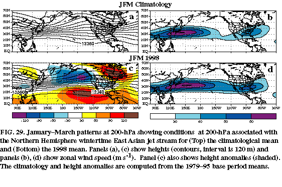
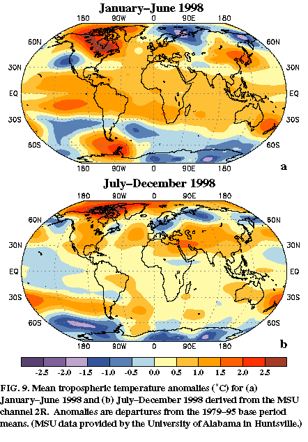
Over the Pacific sector these circulation anomalies reflected several important changes in the flow throughout the Tropics (e.g., the disappearance of the equatorial Walker circulation), the subtropics, and the extratropics. In these latter regions, they reflected the elimination of the climatological mid-oceanic troughs and a pronounced extension to the eastern Pacific of both the mean subtropical ridge (compare Figs. 29a, c) and the region of strong north_south temperature contrast [see section 2b(1), Fig. 9a].
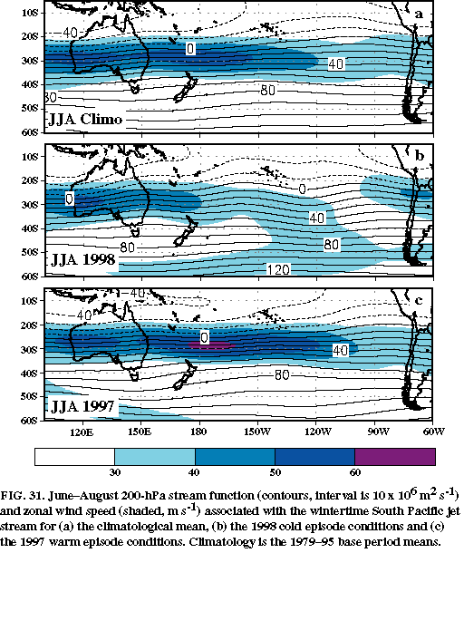
It is evident from thermal wind arguments that these basic state changes in the subtropical height and temperature field must also be associated with a more zonally-uniform westerly flow across the subtropics than is observed in the climatological mean. In the winter hemisphere, this more zonally-uniform flow is associated with an eastward extension of the wintertime jet stream across the central and eastern Pacific (compare N. Hemisphere Figs. 29b and 29d; S. Hemisphere Figs. 31a and 31c). Thus, the anomalous subtropical ridge also establishes an inherent structural and dynamical link between ENSO-related variations in tropical convection and interannual variations in the wintertime jet stream in both hemispheres [Bell and Kousky 1995; Halpert et al. 1996, their section 4a(1)].
The January-March (JFM) period also featured negative height anomalies in the middle and upper troposphere across the extratropical eastern North Pacific and western North America in the vicinity of the climatological mean ridge (Fig. 29c), and over the south-central United States along the cyclonic shear side of the amplified subtropical jet. In contrast, positive height anomalies dominated central and eastern Canada in the vicinity of the climatological mean Hudson Bay trough. This pattern, combined with the anticyclonic circulation anomaly over the subtropical North Pacific, is often referred to as an anomalous wave train [sometimes referred to as a Pacific/ North American (PNA) or Tropical/ Northern Hemisphere (TNH) teleconnection pattern (Wallace and Gutzler 1981; Barnston et al. 1991)] emanating from the subtropics and extending downstream into the extratropics (Sardeshmukh and Hoskins 1988). However, a juxtaposition of the anomaly pattern with the climatological mean height field indicates that these anomalies actually represent a flattening of the climatological mean wave features throughout the eastern North Pacific and North America, consistent with the eastward extension of the wintertime jet from Asia to the southwestern United States.
This interpretation shows that anomaly fields alone cannot accurately represent basic flow features such as extratropical jets (which are integrally related to baroclinic dynamical processes) and waves. Thus, they alone cannot accurately represent the essential dynamical processes, geostrophic adjustment process, and parcel accelerations accompanying the basic state changes in the atmospheric circulation during extremes in the ENSO cycle.
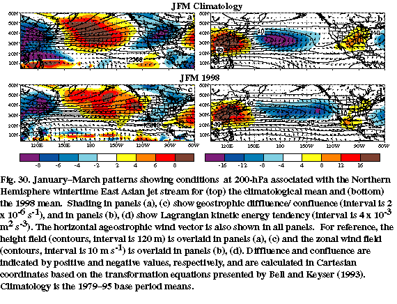
In addition to thermal wind arguments the ENSO-related variations in the subtropical ridges represent a major dynamical forcing of the atmospheric circulation that is strongly baroclinic in nature, and which dramatically impacts both the geostrophic adjustment process and the transverse ageostrophic circulation throughout the jet exit region. During JFM 1998 the extended subtropical ridge contributed to reduced diffluent flow across the central subtropical North Pacific, and to an eastward shift in the region of strong diffluence to the eastern Pacific and California (compare Fig. 30a with 30c). These conditions were accompanied by a eastward shift in the jet exit region toward the eastern Pacific and western United States, and by a concurrent shift in the thermally-indirect transverse ageostrophic circulation and strong deceleration that help to define the exit region (compare Fig. 30d with 30b). Bell and Halpert (1998) noted similar changes in these features within the jet exit region during JJA 1997 in association with the extended Southern Hemisphere wintertime jet stream (Fig. 31c, also see their Figs. 29 and 30). In both cases these basic state changes in the subtropical ridges, the wintertime jet stream, the structural characteristics of the jet exit region, and the entire transverse ageostrophic circulation in the jet exit region reflected a mean flow configuration which is internally consistent with jetstream dynamics (Keyser and Shapiro 1986), and which is also thermodynamically consistent with the distribution of tropical heating.
During JFM 1998 the extended East Asian jet stream was accompanied by a strengthening of the subtropical jet across the southern tier of the United States (Fig. 29d). Moreover, this subtropical jet reflected a deep baroclinic structure and was no longer confined solely to the upper-troposphere.
Accompanying this flow structure was a significantly reduced amplitude of the circulation features that typically characterize the entrance regions of both the subtropical jet and North Atlantic jet. For example, across the central United States in the left jet entrance region, the more prominent of these changes included substantially reduced geostrophic confluence (compare Figs. 30a and 30c) and a reduced strength of both the thermally-direct transverse ageostrophic circulation and Lagrangian kinetic energy tendencies (compare Figs. 30b and 30d). Consistent with these conditions, the ageostrophic wind vectors along the axis of the subtropical jet entrance region were aligned nearly parallel to the isotachs and height contours. This orientation indicates that the primary geostrophic adjustment was linked to flow curvature associated with the large-scale trough over Mexico at this time (Fig. 30c), and no longer linked to along-stream speed variations and dynamical processes typical of a jet entrance region. This interpretation is consistent with the theoretical analysis of Keyser and Shapiro (1986) showing the relative orientation of the ageostrophic wind vector to the isotachs and height contours in idealized jet stream and Gradient wave configurations.
The combined structural changes in the East Asian jet and in the subtropical jet impacted the regions of cyclogenesis and subsequent storm movement across the North Pacific and the United States, as well as the large-scale patterns of vertical motion, precipitation, and temperature across North America. In particular, they contributed to 1) a notable absence of blocking activity at high latitudes of the central North Pacific, 2) enhanced storm activity and precipitation across California and the southern tier of the United States, 3) extreme warmth over most of North America, with record or near-record temperatures across central Canada and large portions of the central and northeastern United States, and 4) a continuation of severe drought in Mexico [see section 4a(3)].
The JJA and SON 1998 seasons featured the evolution to cold episode conditions in the tropical Pacific, as indicated by the establishment of a well-defined tongue of abnormally cold SSTs extending from the west coast of South America toward the date line (Figs. 24e-h). During this period a continuation of oceanic upwelling contributed to a strongly sloped oceanic thermocline, with much shallower than normal thermocline depths evident across nearly the entire eastern half of the equatorial Pacific (Figs. 25c, d ). Accompanying this structure, the depth of the 20°C isotherm shoaled to near 30 m, in stark contrast to the 120-150 m depths observed during the peak of the 1997-98 warm episode.
The evolution to cold episode conditions was accompanied by a dramatic adjustment of
the global monsoon systems, as evidenced by both the OLR and atmospheric wind anomaly
patterns (Figs. 26c, d, 27c, d ). In
particular, enhanced convective activity developed across portions of Indonesia during
JJA, while suppressed convection was evident across the western and central equatorial
Pacific. By SON, this rainfall
anomaly pattern had become well-defined (Figs. 23, 26d ), indicating a confinement of deep tropical convection to the
Indonesian sector and a strengthening of the Australasian monsoon system. Also observed
during SON was increased rainfall across Central America and southern Mexico in
association with a strengthening of that region's monsoon system. These precipitation
patterns are in marked contrast to those observed during the 1997-98 warm episode, which
featured weakened monsoon systems across Australasia and Central America in association
with the eastward extension of tropical convection across the eastern Pacific.
Accompanying the transition to cold episode conditions, the low-level easterly winds during JJA (Fig. 26c) were stronger than normal across the western equatorial Pacific, and generally near normal east of the date line. These conditions contrasted with those observed during the 1997-98 warm episode, when equatorial zonal winds were weak or even westerly across the Pacific basin. By SON enhanced easterly winds were observed across the western and central equatorial Pacific (Fig. 26d), while near-average winds remained over the eastern equatorial Pacific.
At upper levels these periods featured a return to near-normal winds across the eastern equatorial Pacific (Figs. 27c, d) and a continuation of westerly wind anomalies over the western equatorial Pacific. By SON these westerly anomalies had extended to well east of the date line and were accompanied by the development of cyclonic circulation anomalies in the subtropics of both hemispheres flanking the region of suppressed tropical convection. Collectively, these conditions reflected several prominent changes in the atmospheric circulation in the Tropics, subtropics, and extratropics which contrasted to those observed during the 1997-98 warm episode. First, they reflected a strengthening of the equatorial Walker circulation (Figs. 28b, d), compared to a nearly absent Walker circulation earlier in the year (Figs. 28a, b). Second, they reflected a pronounced westward retraction of the subtropical ridges in both hemispheres, along with a strengthening of the mid-Pacific troughs (Fig. 31b). Third, they reflected a weaker and substantial westward retraction of the wintertime jetstream over the South Pacific (Fig. 31b ), which is in dramatic contrast to the well-defined jet stream that extended across the entire South Pacific during JJA 1997 (Fig. 31c, see also Bell and Halpert 1998, their Figs. 29 and 30).