[Previous Article] [Next Article]
A statistical system to objectively forecast southern African summer rainfall one season in advance is described,
and the current forecast shown. Long-range predictive skill for southern Africa is moderately high because of links with
the global El Niño-Southern Oscillation (ENSO) and regional climate telecon-nections. ENSO signals near Africa have
been documented (Jury et al. 1994) and hemisphere-scale precursor patterns have been described using correlational
statistics (Jury 1996). Global data sets include sea surface temperature (SST) from COADS and UKMO data sets, upper
winds from CPC and ECMWF gridded products, surface air pressure and winds from COADS, ENSO and quasi-biennial oscillation indices from CPC, and satellite cloud estimates via outgoing longwave radiation (OLR) and highly
reflective cloud albedo from CPC from 1971 to the present. Key areas identified by Rocha (1992) and Pathack (1993)
offering high correlation at one season lead time were considered. Rotated principal component patterns for global SST
were analyzed from normalized departures. Because of the repeated selection of satellite OLR indices in preliminary
analyses, all model training periods were limited to 1971-1993.
Because forecasts are required in the austral spring for management purposes, predictors for the July to November
period were considered. To reduce intra-seasonal noise, three month means were used. Various exploratory analyses
enabled over 100 candidate predictors to be identified. Target rainfall data were obtained from national weather services
in the region. Emphasis was placed on areas with significant water resources and rain-fed agricultural production.
Rainfall station data were spatially grouped according to annual total, seasonal cycle, elevation, and intercorrelation
structures (e.g. principal components). Area-averaged targets were about 300 km diameter as in Landman (1995), and
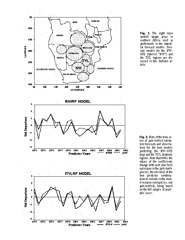
are shown in Figure 1. It was considered that a larger area-average improves the signal-to-noise ratio and thus the
potential for predictability, up to a spatial limit defined by local users. Monthly station rainfall normalized departures
were averaged for early and late summer seasons: November to mid-January and mid-January to March, respectively.
This represents a compromise between "noisy" single month targets and user needs for guidance on the temporal
distribution of rainfall within the summer season.
Of the >100 candidate predictors developed, the SST predictors are principal components and the others are
averages over key areas based on maps of lag correlation between the field predictor and the target rainfall. The size
of a predictor depends on the size of the significantly lag-correlated region. Ultimately 49 predictors were selected by
15 area-specific models. Of the 49 predictors, about one-third are significantly correlated with the Southern Oscillation
Index and eastern Pacific (Niño 3) sea surface temperatures; another one-third (some overlapping) describe the transition
of the Indian NE monsoon; about one-quarter reflect conditions over the South Atlantic and persistence of standing
westerly waves in the subtropics. To facilitate an understanding of the climate dynamics and to improve forecast skill,
lead times of one season were considered. All rainfall indices were standardized (mean=0, SD=1) in the 1971-1993
training period.
Multiple linear regression models were developed using standard Statgraphics and Genstat software. Each summer
rainfall predictand index was fitted by an optimum mix of statistically significant spring predictors using a forward
stepwise procedure. To control over-fitting and artificial skill, a maximum of 5 predictors was imposed. Models were
formulated to achieve maximum hindcast adjusted r-squared values, using the conventional adjustment for estimated
shrinkage due to fitting on the training sample. A number of potential candidate models were developed for each target
area and then subjected to skill validation tests. Models with co-linear pairs of predictors having oppositely-signed
coefficients were screened out. The final selection of model for each target was based on an optimum skill correlation
giving a maximum hindcast fit.
The predictors used in the models for seven early summer target regions consisted of 13 SSTs, 4 OLR, ENSO or
QBO indices, and 14 wind or pressure predictors, and had a mean hindcast r-squared of 65% for 17 degrees of freedom.
Models for eight target regions for late summer rainfall had a mean hindcast r-squared fit of 69% and the predictors were
divided among SST (18), OLR/index (10), and wind/pressure (9). The equations for two late summer targets using Sep-Oct-Nov predictors over the northeast plateau of South Africa are:
NW-OFS = -.75(QBO-1) +.58(Wolr) +.40(SOI) -.45(Elu)* r2 fit = .73
TVL = -.36(QBO-1) -.43(ATpc4) -.67(CIst) +.29(Atpc3) = .64
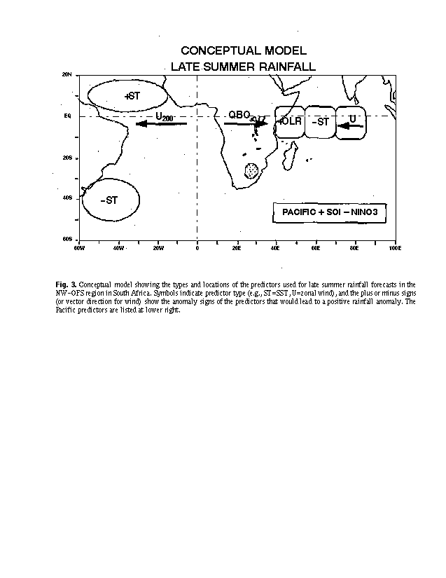
*JAS time period (see Fig. 3 for predictor identities and locations)
A partial validation of the model skill was done using a jack-knife technique, where each year was held out in turn
and the predictor term coefficients (but not the choice of predictors) were determined from the remaining years and used
to forecast the withheld year. Mean correlations between observed and model predicted values were .73 for early
summer and a somewhat higher .79 for late summer models. A statistical "miss" rate is currently in the process of being
defined. Examples of time series of forecasts and their corresponding observations resulting from the jack-knife
procedure for the two South African highveld target models are shown in Figure 2. The model for the Transvaal target
yields a jack-knife correlation skill of .73 (lower than the .80 for the r fit).
It should be noted that the skill scores shown in Fig. 2 may be somewhat overestimated because of the large
number of candidate predictors, the limited degrees of freedom (short training period), and the fact that the jack-knife
validation exercise was conducted on predictor combinations that had already been selected using the entire available
sample. Thus, while the jack-knife results indicate very high skill, skills in real-time forecasts are expected to be lower
by a currently unknown amount. The true skill level may still be quite useful, and perhaps better than existing empirical
models because of the use of new predictors such as those derived from the OLR data.
Conceptual models can be used to facilitate an understanding of the climate dynamics and ocean-atmosphere
coupling that underlie the predictive relationships. Plentiful summer rains follow from a high phase ENSO condition
with Pacific SOI positive, Niño 3 SST negative, and tropical Atlantic 200 hPa winds easterly. The late summer models
for the two adjacent South African plateau areas (NW-OFS and TVL) include the following Sep-Oct-Nov predictor
anomalies with respect to increased rainfall:
- QBO in west phase (east phase previous year-1)
- tropical Indian Ocean SST negative in central
area
-surface winds easterly (JAS season) and SST positive in east tropical Indian Ocean, and convection reduced
(positive OLR) in west (near equatorial African coast)
- Atlantic Ocean SST negative in southwestern mid-latitudes (centered 40S, 45W) and positive northeast
of Brazil
The Atlantic SSTs potentially influence the disposition of standing westerly waves. The eastern tropical Indian
Ocean predictors describe the ENSO state in terms of circulation and SST. Figure 3 summarizes the key model
predictors and what their signs would be in order to enhance southern African rainfall. A subset of these is used in
Hastenrath et al. (1995), in which the sense of the relationships agree.
For the spring (or earlier) 1996 predictor periods, the conditions of the major predictors are as follows, with
implications of southern African 1996-97 summer rainfall indicated:
-ENSO condition (SOI and Niño 3 SST): weak La Nina (=>wet)
- tropical central Indian Ocean SST: neutral
(=>neutral)
-QBO previous Sep-Oct-Nov: westerly (=>dry)
-surface winds (JAS) in east tropical Indian Ocean easterly (=>wet)
-SST in east tropical Indian Ocean warm (=>wet)
-OLR in west tropical Indian Ocean high (=>wet)
-Atlantic Ocean SST in SW mid-latitudes cool (=>somewhat wet)
-Atlantic Ocean SST northeast of Brazil neutral (=> neutral)
The forecasts for late summer 1996-97 (expressed as percentages of mean 1971-93 mean rainfall) for several
southern African regions, based on the above diagnostics through the chosen multiple regression equations (or in some
cases, ensembles from more than one equation), are as follows:
Forecast:
Mid-Jan
to March
1996-97 Region (% of mean)
Eastern Cape 114
NW-OFS Provinces 87
Gauteng-North-
Mpuma Highveld 108
Swazi-KZN-Lowveld 130
N. Namibia 72
Zimbabwe 107
Note: Jack-knife correlation skill for all of the above forecasts is .60 or greater. Note also the caveat on the estimation
of skills, discussed above.
Roughly near-average rains may be expected. Adequate rainfall is forecast over the western highveld and
eastern Cape of South Africa. Rainfall deficiency in N. Namibia should be milder than previous summer.
The above forecasts are part of a larger set of specialized southern African forecast information (including climate
impacts such as maize yield, malaria incidence, major river flows, Indian Ocean tropical cyclone days) posted on the
website of the Cape Town Weather Watch during spring (September to December). The Internet address is <http://os2.
iafrica.com/weather> under the forecast menu, with the current address: <http://www.sea.uct.ac.za/weather
/forecast/ctww_seasonal_outlook.html>. This seasonal long-lead forecast service is maintained in support of farmers,
resource managers and regional businesses. Many of the models have been developed in collaboration with SADC
national weather services. The outlook is updated regularly in spring (August to December). Post-season analysis and
verification is done and forecast errors are analyzed with a view to refinement of the models. It is believed that
agriculture and other climate-impacted economic activities can benefit from long-range forecasts based on climate
teleconnections, thereby improving the economic growth potential of southern Africa.
Acknowledgments: Data were supplied by the CPC (NCEP), UK Meteorological Office, ECMWF, SADCO South
Africa, CCWR South Africa, and the national weather services of South Africa, Zimbabwe, Namibia, Zambia, Tanzania,
Madagascar and Mauritius. COADS and OLR data were quality checked and re-analyzed by Prof. B. Wang of the
University of Hawaii. SST principal component patterns/scores were supplied by Dr. S. Mason, University of
Witwatersrand in Johannesburg. Statistical analyses were performed by A. Brandao of University of Cape Town. The
research was sponsored by the Water Research Commission South Africa, and Eskom South Africa.
Hastenrath, S., Greischar, L., and Van Heerden, J., 1995: Prediction of the summer rainfall over South Africa. J.
Climate, 8, 1151-1518.
Landman, W. A., 1995, A canonical correlation analysis model to predict South African summer rainfall. Exp.
Long-Lead Forecast Bull., 4, 4, 23-24.
Jury, M. R., McQueen, C. A., and Levey, K. M., 1994: SOI and QBO signals in the African region. Theor. Appl.
Climatol., 50, 103-115.
Jury, M. R., 1996, Regional teleconnection patterns associated with summer rainfall over South Africa, Namibia
and Zimbabwe. Intl. J. Climatol., 16, 135-153.
Pathack, B. M. R., 1993, Modulation of South African summer rainfall by global climatic processes. PhD Thesis,
Univ. of Cape Town, 214 pp.
Rocha, A. M. C., 1992, The influence of global sea surface temperature on southern African summer climate. PhD
Thesis, Univ. Melbourne, 248 pp.
Fig. 1. The eight main rainfall target areas in southern Africa used as predictands in the statistical forecast models.
Forecast models for the NW-OFS (labeled "NW") and the TVL regions are discussed in this Bulletin article.
Fig. 2. Plots of the time series of jack-knifed validation forecasts and observations for the best models predicting
the NW-OFS (top) and the TVL (bottom) regions. Note that while the values of the coefficients change with each year
held out in turn in the jack-knife process, the selection of the best predictor combinations to include in the model
remains constant (i.e. not jack-knifed), being based on the full sample of available cases.
Fig. 3. Conceptual model showing the types and locations of the predictors used for late summer rainfall forecasts
in the NW-OFS region in South Africa. Symbols indicate predictor type (e.g., ST=SST, U=zonal wind), and the plus
or minus signs (or vector direction for wind) show the anomaly signs of the predictors that would lead to a positive
rainfall anomaly. The Pacific predictors are listed at lower right.