[Previous Article] [Next Article]
Dynamical Seasonal Prediction of the Indian Summer Monsoon
contributed by Mike Harrison1, M. K. Soman3, Mike Davey2,
Tony Evans1, Kelvyn Robertson1 and Sarah Ineson2
1NWP Division 2Ocean Applications Branch
UK Meteorological Office, Bracknell, United Kingdom
3Indian Institute of Tropical Meteorology, Pune, India
As part of a European PROVOST experiment (PRediction Of climate Variations On Seasonal and
interannual Timescales), the UKMO Unified Model at Climate resolution has been integrated in
9-member ensembles initialized at 24 hour intervals for four months for each season for the years
1979-1993. The SST anomalies from UKMO GISST and Reynold's OI data sets were used in all
experiments. All initial-izations were at 0000Z finishing on the day prior to the start of the season.
The summer monsoon is an important part of the general circulation of the atmosphere, and the
rainfall during this season (June through September) is of vital importance for the people of India
and countries of south and southeast Asia. In India, the seasonal forecast of monsoon rainfall has
traditionally been issued using a number of statistical techniques (see Kumar et al. 1995, for a
review). One of the major boundary forcings affecting the interannual variability of the summer
monsoon is the ENSO phenomenon. Since PROVOST experiments use the observed SSTs during
the 15 year period as the lower boundary condition, it provides a good opportunity to assess the
possibility of using a sophisticated atmospheric dynamical model for predicting the Indian summer
monsoon rainfall.
Here, the monsoon simulations from a 9 member ensemble integration of the Unified Model for
summer of 1997 is analyzed. The ensembles were started with initial conditions from 23 May to
31 May and continued until the end of September. The observed SST anomalies for May, 1997
was persisted throughout the season. Simulations from the 15 year, 9 member ensemble
PROVOST integrations for the summer season (July - September) are used for comparing this
year's results.
In the mean, the model simulates reasonably the distribution of monsoon rainfall and wind.
However, the model rainfall is higher, and lower tropospheric winds stronger, than the observed
values over the whole monsoon region. Additionally, the interannual varia-bility of monsoon
rainfall over India simulated by the model is low compared with observations. However, during El
Niño years the model tends to simulate lower rainfall over India in June and higher rainfall in July
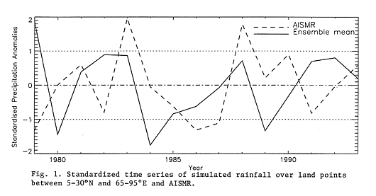
to September. In Fig. 1, plots are shown of the standard-ized time series of the ensemble mean
rainfall July- August-September over land areas between 5-30N and 65-95E, and the measured
All India Summer Monsoon Rainfall (AISMR) (Parthasarathy et al. 1992) series. The mean
rainfall over the land area simulated by the model is 62.5 cm with a standard deviation of 2.1 cm,
whereas AISMR has a mean of 66.7 cm with standard deviation 7.7 cm. In El Niño years (1982,
87, 91) the model did not simulate the negative departures evident in the observations. In fact, it
simulated positive departures in 1982 and 1991 and no departure in 1987. The correlation
between the two lines in Fig. 1 is barely above zero, being over 0.6 for June and July individually
but below zero for August and September. However, we discuss below how the model forecasts
do give us some valuable information.
As already mentioned, the model rainfall over Indian land areas shows relatively small interannual
variability. The statistics for the 1997 ensemble integrations are given in Table 1. It is clear from
this table that on average, normal monsoon rainfall is indicated during July-September of this year.
Over India the ensembles have high spread, the standardized values varying from -1.7 to +1.6.
The simulation is quite different for individual months. The observed monthly mean SST anomaly
for May is persisted in the integrations. In June, all 9 ensemble members indicate negative rainfall
departures, the ensemble mean standardized deviation being -1.45. In July the model also
indicates below-normal rainfall with 7 ensemble members showing negative departure, with a
standardized deviation of -1.2. By August, positive rainfall departures start being shown by the
model; in September, modeled rainfall anomalies over India are positive (ensemble mean
standardized value is +1.2) with 6 out of 9 members of the ensemble having positive departures.
A weak monsoon is indicated by
Table 1. Simulated mean rainfall over land points between 5-30N latitude and 60-95E longitude.
| Precip (cm) | % Departure1 | Stand. Variables2 | Adjusted Precip (cm)3 | % Departure4 | |
| Member 1 | 60.4 | -3.1 | -0.95 | 59.4 | -11.0 |
| Member 2 | 64.8 | 3.9 | 1.18 | 75.8 | 13.7 |
| Member 3 | 64.1 | 2.8 | 0.86 | 73.4 | 10.0 |
| Member 4 | 64.2 | 3.0 | 0.91 | 73.7 | 10.5 |
| Member 5 | 65.6 | 5.2 | 1.58 | 78.9 | 18.3 |
| Member 6 | 63.5 | 1.8 | 0.56 | 71.0 | 6.5 |
| Member 7 | 58.8 | -5.6 | -1.69 | 53.6 | -19.6 |
| Member 8 | 61.9 | -0.7 | -0.22 | 65.0 | -2.5 |
| Member 9 | 61.5 | -1.3 | -0.38 | 63.8 | -4.4 |
| MEAN | 62.7 | 0.68 | 0.21 | 68.3 | 2.4 |
1 Percentage departure from 15 year model climatology.
2 Standardized variables with 15 year model mean and SD.
(Mean= 62.32 cm; SD=2.05 cm)
3 Precipitation scaled with AISMR mean and SD
(std. var x SD + Mean) Mean= 66.7 cm; SD=7.72 cm
4 Percentage departure of estimated precipitation.
the model over India at the beginning of the season and a strong monsoon at the end of the
season. However, it is indicated by the simulations over the 15 year period (1979-1993) that the
strong monsoon at the end of the season is not handled well by the model.
The simulated rainfall for 1997 over land points of India for July-September is normal. However,
the distribution of rainfall over Bay of Bengal and other parts of southeast Asia indicates a
drought-like condi-tion for India, as we next explain. Though the rainfall over India simulated by
the model shows little response to El Niño /La Niña conditions on a seasonal scale, the rainfall in
the Bay of Bengal and over southeast Asia does show a more significant response. These seasonal
responses are not correct, but they are seen consistently in all El Niño years. During El Niño
years, there is a decrease in rainfall over most of the Arabian Sea, the equatorial Indian Ocean and
the equatorial west Pacific. A belt of positive anomalies extends from the Indian peninsular to the
west Pacific between 10-20N. In La Niña years an opposite signal is obtained. This pattern of
anomalies is a consistent feature of the model. The 10-year AMIP integration (1979-1988) of the
same version of the model produces the same signal.
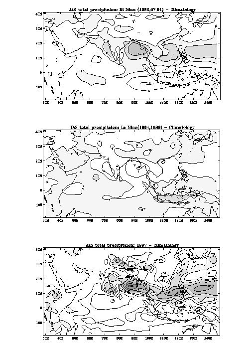
During the 15 years covered under PROVOST, 3 years (1982, 87 and 91) were El Niño years and
2 years (1984 and 88) were La Niña years. Composite precipitation and wind charts for these
years show that the simulation of the monsoon responds strongly to Pacific SST anomalies.
However, the anomaly patterns are quite different from those seen in the observations. The
ensemble mean composite precipitation anomalies during El Niño and La Niña years and for 1997
are shown in Figure 2. The model shows an increase in precipitation over Peninsular India, the
Bay of Bengal and the west Pacific between lat. 10-20N during El Niño years. In La Niña years
there is a decrease in rainfall over the western coast of India, Bay of Bengal and southeast Asia
and west Pacific north of 10N. The model does show correct rainfall anomalies over northwest
India, the region known to have highest correlation with predictors used in the statistical long
range forecast of the monsoon rainfall over India.
The spatial distribution of the total precipitation anomalies (bottom panel of Fig. 2) indicates
clearly that the model is simulating the monsoon rainfall distribu-tion observed typically in El Niño
years. The fact that modelled rainfall is below-average during the first two months of the monsoon
supports this conclusion. The spatial distribution of rainfall anomaly of the ensemble mean
resembles the simulated rainfall distribution for the years of 1982, 87 and 91 (top panel of Fig. 2)
when India received less than normal rainfall.
The present skill of the model does not allow a quantitative forecast of the monsoon rainfall over
India. However, the spatial pattern of anomalies does indicate below-average rainfall over
India during July-September, 1997.
It would be possible to demonstrate the model's skill more formally by performing a systematic
error correction procedure, on the pattern level, on the raw model forecast output. Statistical
tools such as canonical correlation analysis (CCA) or singular value decomposition (SVD) could
be used for such a pattern correction. Presently we are using human pattern recognition to do this
job, and hence are unable to provide proper "error bars" or probability distributions along with
the dry Indian summer forecast. In the absence of a pattern correction, simpler schemes could be
used to estimate the forecast skill, such as the strength of the negative correlation between the
rainfall forecast for the Bay of Bengal forecast and the subsequent AISMR. For now we hope the
reader will agree that some usable level of skill is implied from the top and bottom panels of Fig.
2. We intend to assess the model skill more rigorously in the future.
Kumar, K., Soman, M.K. and Rupa Kumar, K., 1995: Seasonal forecasting of Indian summer
monsoon rainfall. Weather, 50, 449-467.
Parthasarathy, B., Kumar, K.R., and Kothawale, D.R., 1992: Indian summer monsoon rainfall
indices, Meteorol. Mag.. 121, 174-186.
Fig. 1 Standardized time series of simulated rainfall over land points between latitude 5-30N and
longitude 65-95E and AISMR.
Fig. 2. Rainfall anomaly from model climatology for El Niño (top) and La Niña (middle) years and
from the 1997 model monsoon rainfall forecast (bottom).