[Previous Article] [Next Article]
Seasonal Prediction of Summer Monsoon Rainfall
in Central-East China
contributed by Xu Qun1 and Yang Qiuming2
1Jiangsu Meteorological Institute, Bei-Ji-Guo #2, Nanjing 210008, China
2Jiangsu Meteorological Observatory, Bei-Ji-Guo #2, Nanjing 210008, China
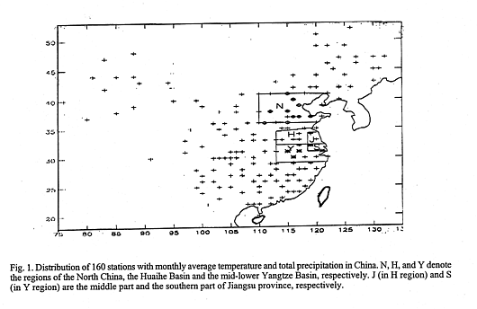
Central-east China (CEC), including the middle/lower Yangtze Basin, the Huaihe Basin and the north China, is a densely populated, highly economically active region which has also suffered from frequent occurrences of floods and droughts caused by the anomalous distribution of summer monsoon rain. Xu has engaged in the research of seasonal prediction (SP) for many years with some success (Xu 1986, 1988, 1995). Predictors were selected mainly from preceding monthly 500 hPa height anomalies of the northern hemisphere (NH), the SST anomalies of the North Pacific and the surface climate anomalies of China during January-March. Thus, Xu has issued the summer season prediction usually by early April. Now we try to improve on former work by using formal statistical tests. The 11 predictands are regional rainfall based on 5 or more stations to smooth out local effects. These area-averaged rainfalls are likely to be somewhat predictable on a month to season timescale by virtue of their association with averaged large scale atmospheric circulation. The locations of these predictands are shown in Fig. 1. The 11 pre-dictands are:
1. Yanr68: Summer average rainfall of 10 stations in the mid-lower Yangtze Basin (29.2-32.2N,
east of 113E; the Y region in Fig. 1).
2. Meiyu: Percentage of total rainfall of 5 stations located in Y region during the period of Meiyu
(plum rain). Xu (1965) has objectively defined the Meiyu period using data for 80 years. This
definition, based on the axial latitude of the summer monsoon rainy belt in east China, is used for
the more recent years too and used to produce a Meiyu rainfall anomaly series for each year since
1885, relative to the normal of 100 recent years (1885-1984).
3. Onsemei; 4. Outmei: Date of onset of Meiyu period and the first day after the end of Meiyu.
5. Snmei; 6. Jnmei: Based on the daily rainfall of 2 sets of 5 stations evenly distributed in the
south part and middle part of Jiangsu province (S and J region in Fig. 1), we delimit the rainy
period in these regions and calculate their total rainfall per year since 1951 by the same criterion
of Meiyu.
7. Huai67r; 8. Huai78r: The average rainfall of Huaihe Basin during June-July (67r) and
July-August (78r), based on the data of 8 stations evenly distributed in H region of Fig. 1.
9. Jian78r: Averaged high summer (July-August) rainfall of the south-east part in the
Yangtze-Huaihe Basin, including data of 10 stations located in the region 30-33.6N, east of 114E.
10. Nor78r: Averaged high summer rainfall of the North China, including data of 10 stations in N
region of Fig. 1 (36-41N, east of 110E).
11. Kn: Pentad number in July-August, during which the latitude of the ridge line of the
northward Pacific high at the 500 hPa level exceeds 26N within the of 110-130E longitude
section. The location of the summer monsoon rainy belt in eastern China is generally modulated
by the ridge line's latitude of the West Pacific High (WPH) at 500 hPa with the former north of
the latter by 8-10 latitude. Therefore, if Kn is larger (smaller), showing that the WPH is farther
north (south), this will lead to more (less) rainfall in the North China with less (more) rain in the
Yangtze-Huaihe Basins in July-August.
According to Xu (1986,1988), we select four predictor fields from monthly averages of the
fol-lowing data fields for January-March:
1. Monthly 500 hPa height fields of the NH for 576 grid points (10-85N), 1951-1996.
2. Monthly sea surface temperatures (SST) of the North Pacific for 286 grid points, 1951-1996.
3. Monthly temperature for 160 stations evenly distributed throughout China, 1951-1996.
4. Same as 3. except for precipitation.
The above data were obtained from the Central Meteorological Observatory of China (Beijing).
The process of selection for predictors is as follows: We calculate correlation fields between each
predictand and all four monthly data fields (listed above) for the preceding January, February and
March. Hence there is a total of 132 fields (11 predictands x 3 months x 4 predictor data fields)
were produced. Regions were then selected from these correlation fields whose data averages
may make useful predictors for one or more of the 11 predictands using the following criteria:
1). An average of at least 3 adjacent grid points (stations) needed to be used.
2). The correlation between the predictor and predictand must be significant at the 2.5% level.
The selected predictors were then combined to form multivariate linear regression equations
(REs).
Before assessing the likely usefulness of these REs for forecasts by assessing the REs on
independent data, the REs were assessed on dependent data using the following criteria:
1). The correlation between predictions and observations must be significant (R>0.75).
2). Statistically significant benefit of each RE, with the extent of benefit satisfying F>7.0. This
demonstrates that a significant difference exists between each of the regression coefficients and
zero, indicating that each predictor of each RE plays a significant role of its own.
The above criteria force us to select a minimal number of predictors with both high correlations to the predictand and low correlations among themselves. Data periods used for establishing REs have been examined, and it was found that the 20-year length is the best period for minimizing the effect of interdecadal variability and climate change on the REss. We have established 4 sets (4*11) of REs for the periods of 1970-1989, 1973-1992, 1975-1994 and 1997-1996 respectively. Using these REs, we have made 15 hindcasts for each predictand, which are listed below:
| Hindcasts for Preceding Summers | Base Periods for REs | Hindcasts for Following Summers |
| none | 1970-1989 | 1990, 1991, (1992) |
| (1970, 1971, 1972) | 1973-1992 | 1993, 1994, (1995) |
| (1973, 1974) | 1975-1994 | 1995, 1996 |
| (1975,1976) | 1977-1996 | none |
The hindcasts of the above 15*11=165 cases were assessed using a Chi-squared test for the hindcast and observed predictand values which were categorized in terms of 3 terciles. The terciles of both forecast and observed predictands for each summer change as a function of which base period is used to develop the RE model and also the climatological "normals". We found that the entire set of hindcasts was skillful on an overall basis, which was demonstrated by the ratio between successful forecasts, of "hits" (SF), a 1-category error (E1), a 2-category error, or severe failure (F), and the corresponding value of Chi-squared and its statistical significance:
| Development
Period |
Observed
Ratios (SF:E1:F) |
Randomly
Expected Ratios |
Value of Chi-squared |
Statistical
Significance Level |
| All hindcasts (N=165) | 85:66:14 | 55:73:37 | 29.9 | 0.001 |
| 2 summers following
the base period (N=66) |
46:20:0 | 22:29:15 | 42.3 | 0.001 |
| All except the 2
summers following (in parentheses in previous table; N=99) |
39:46:14 |
33:44:22 |
3.5 |
0.10 |
The 66 hindcasts for each of the subsequent 2 summers for the 3 base periods (1970-1989,
1973-1992, 1975-1994), made by the 33 corresponding REs, were especially skillful, significantly
exceeding the 0.001 level; none of them met with the failure of a 2-category error. (Of course,
their performance would still be worse, correlation-wise, than what was found within the
development sample.) This portion of the entire set of 165 hindcasts is responsible for the success
of the entire set. The remaining 99 cases, including all summers preceding the base periods and
summers 3 years following the development period, were not skillful. The contrast of hindcast
skill levels between development periods (2) and (3) is consistent with the benefit of using shorter
length (20-year) base periods for the REs. Xu (1986, 1988) has found that the interseasonal
relationship between predictors and the distribution of summer monsoon rain in CEC has changed
considerably since late 1970s due to the strengthening of global warming and an abrupt increase in
aerosols originated from both volcanic eruptions around the globe and industrial development in
China. Thus, using a base period of longer than 20 years for the REs would blend different climate
regimes and lower the skill. The results of the above hindcasts also show that skillful forecasts can
be made only in the subsequent 2 years of the base period; i.e., avoiding predicting a year too far
away from the 20-year development period. As for the low skill for the years preceding the base
period, an explanation is not known. We speculate that there may have been a more rapid change
in the coupled influences of interdecadal climate oscillation changes in anthropogenic effects for
China in the 1970s than in the 1990s.
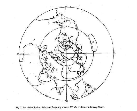
It is notable that half of predictors (82/163) of 44 REs are monthly 500 hPa height fields of
January-March, showing the importance of prior atmospheric anomalies for predicting summer
monsoon rainfall in CEC. Among the grid points of the atmospheric anomaly predictors, the grid
points of predictors appearing at least 3 times are concentrated in a set of regions circling on CEC
(Fig. 2) Most (59.9%) of these points are located in 40-60N, the second greatest number
appeared in the northern subtropics (25-30N) and northern polar region (75-80N), and only 4.2%
appeared in the Tropics (10-20N). The region of highest concentration is in the northwestern
Pacific (140-180E, 45-60N) and the temperate zone of East Asia (80-120E, 35-55N). This
indicates the importance of 500 hPa anomalies over both the east and west sides of the polar
trough of East Asia, which may reflect an interseasonal relationship between the thermal contrast
between the northwestern Pacific and the Asian continental temperate zone in January-March, and
the summer distribution of monsoon rain in CEC. Other key regions were located in the Barents
Sea of the Arctic Ocean, the subtropics of Central Pacific, the Middle East, the South India, and
others.
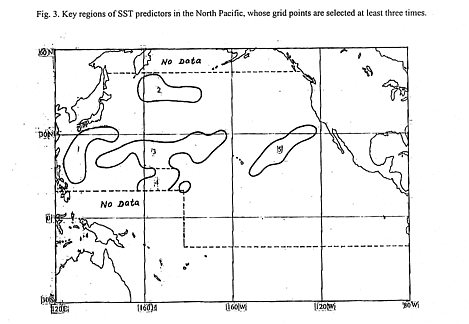
SST is not used in the REs as much as 500 hPa predictors. Figure 3 shows that most monthly
SST predictors are located in the subtropical (15-30N) North Pacific, some of them associated
with oceanic currents. For example, region 1 is near the Kuroshio current, and region 2 is in the
convergent zone of the North Pacific current and Kurile cold current. Region 4 is near the warm
pool of western tropical Pacific. However, no concentrated region of predictors was found in the
ENSO-related region of 10N-10S and eastward of 175W. The infrequent usage of ENSO-SST
and the SOI (only 2 out of 163 predictors) indicates that except for effects from the warm pool,
ENSO's influence on CEC summer monsoon rainfall is not significant. ENSO's teleconnection
patterns as shown by Ropelewski et al. (1989) and Halpert et al. (1992) exclude CEC; this is
consistent with the low occurrence of 500 hPa predictors in the Tropics, showing large causal
differences between summer monsoon rain of CEC and India.
Preceding regional climate anomalies in China have an equal weight with the predictors from SST
of the North Pacific. The regional precipitation anomalies in January-March play a major role,
comprising 74.4% of this class of predictors. They are positively correlated with summer
monsoon rain of some regions in CEC. Most (82.8%) of them are located within 4 north or south
of the predictand regions, at about the same longitude. Since the 1980s, many studies such as
Rowntree et al. (1983) and Folland et al. (1989) have verified that the prior soil moisture
condition is important in modulating local rainfall and atmospheric circulation with a lag of a few
months. Our results indicate that some regional precipitation anomalies in China during
January-March do influence the distribution of summer monsoon rain in CEC, probably through
the interseasonal influence of deep layer soil moisture.
Among our 4 sets of REs, most of them contained 4 predictors (70%) or 3 predictors (25%). The
predictor selection is modulated by time, and the period of skillful application extends only 2 years
following the development period. As an example of an RE, we illustrate the equation for Meiyu
(plum rain):
Y = 90.46 +0.35h51a +0.58h52a +0.32h53a +0.11St2a
(Base period: 1970 - 1989, F = 9.6, R = 0.85)
The 4 predictors in the RE above are:
(1) h51a - the average January 500 hPa height of 7 grid points located in region 2 (4 grid points) and region 4 (3 grid points), separately.
(2) h52a - the average February 500 hPa height of 4 grid points located in the west of Lake Baikal (in region 1 of Fig. 2).
(3) h53a - the average March 500 hPa height of 10 grid points located in region 3 of Fig. 2.
(4) St2a - the difference of February SST between A and B, where A is the average SST of 5 grid
points located in the north part of region 5 (in Fig. 3), and B is the average SST of 5 grid points
located in the east part of region 3.
The above RE scored hits for the independent hindcasts for summer 1990 and 1991, and a
1-category error for 1992. When REs are derived for slightly later 20-year periods for Meiyu,
somewhat different predictors are chosen. While most of the changes are only minor shifts in the
locations of the predictor clusters, occasionally a predictor of a given type may entirely disappear
or appear. Although the REs for a given predictand are modulated over time, they are feasible
tools with which to conduct regional seasonal prediction (SP). Presently we have been able to
show strong statistical significance of independent forecast skill. When more independent
forecast cases become available, a more concrete estimate of the skill (e.g., an expected
correlation with independent observ-ations) will be possible. In addition to the skillful
hindcasts of the subsequent two summers of 3 base periods, we made a real-time SP on 14 April
1996 based on the REs of the 1975-1994 period. The prediction was for severe flooding in the
mid-lower Yangtze Basin and Huaihe Basin during June-July 1996 with an early onset and
delayed ending date of Meiyu, which turned out to be fully correct. As mentioned above, very few
of the predictors are ENSO-related, as CEC is outside of the influence of the SOI. This may
provide clues to SP for other extratropical regions.
PREDICTION FOR SUMMER 1997
We use the newly established REs with a base period of 1977-1996 for the SP for this summer,
issued on April 19,1997:
The predicted values of the 11 predictands for summer 1997 are:
Yanr68: +288.0 (Flooding)
Meiyu: 138.2% (Flooding)
Onsemei: 18-19 June (Normal)
Outmei: 18 July (Late)
Snmei: 182% (Flooding)
Jnmei: 109-129% (Above normal)
Huai67r: 408 (flooding)
Huai78r: 260 (normal)
Jian78r: +39.1 (Normal)
Nor78r: +3% (Normal)
Kn: 6 (Normal).
Significant positive anomalies will appear in the monsoon rains of Yangtze-Huaihe Basins during
June/July 1997 with heavy Meiyu occurring in the mid-lower Yangtze valley; its onset day may be
near normal but with later ending date. Positive anomalies of plum rain will prevail in the middle
and southern parts of Jiangsu province with even more than 150% of normal appearing in the
latter. The Huaihe Basin will suffer from waterlogging in the last ten days of June to the second
ten days of July, but its rainfall may be less than normal in August. The high summer
(July/August) monsoon rain of North China will be near normal. In short, we should be highly
vigilant with respect to possible flooding of Meiyu occurring in a considerable portion of
the Yangtze-Huaihe Basins in late June to mid-July 1997.
Acknowledgments: Sincere thanks are extended to Andrew Colman (UK Meteorological Office)
and Anthony Barnston (Climate Prediction Center, NOAA) for their helpful comments and
suggestions in statistical forecast techniques.
Folland,C.K., J.A.Owen and D.E.Parker, 1989: The Influence of Sea Surface Temperature and
Soil Moisture Anomalies on Sahel Rainfall. Second WMO Workshop on the Diagnosis and
Prediction of Monthly and Seasonal Atmospheric Variations over the Globe. WMO/TD,
NO.261, 77-81.
Halpert,M.S. and C.F.Ropelewski, 1992: Surface Temperature Patterns Associated with the
Southern Oscillation. J. Climate, 5, 577-593.
Ropelewski, C.F. and M. S.Halpert, 1989: "Typi-cal" ENSO-precipitation Patterns as a Prediction
Tool. Second WMO Workshop on the Diagnosis and Prediction of Monthly and Seasonal
Atmospheric Variations over the Globe. WMO/TD, NO.261, 49-52.
Rowntree, P.R. and T.A. Bolton, 1983: Simula-tion of the atmospheric response to soil moisture
over Europe. Quart.J.Roy.Meteor.Soc., 109, 501-526.
Xu Qun, 1965: The plum rain (Meiyu) of the middle and lower Yangtze Valley for 80 recent
years. Acta Meteorological Sinica, 34 (4), 507-518.
Xu Qun, 1986: The Seasonal Flood/Drought Trend Forecasting and Diagnosis for the Middle
and Lower Yangtze Basin in 17 Recent Years. Proceedings of Monthly and Seasonal
Atmospheric Variation over the Globe, WMO/TD, NO.87, 626-636.
Xu Qun, 1988: A Feasible Way to Seasonal Weather Trend Forecasting. First WMO Conference
on Long-range Forecasting, WMO/TD, NO.147, 95-105.
Xu Qun, 1995: Analysis of causes and seasonal prediction of the severe floods in Yangtze-Huaihe
Basins during summer 1991, Advances in Atmos. Sci, 12 (2), 215-224.
Fig. 1. Distribution of 160 stations with monthly average temperature and total precipitation in
China. N, H, and Y denote the regions of the North China, the Huaihe Basin and the mid-lower
Yangtze Basin, respectively. J (in H region) and S (in Y region) are the middle part and the
southern part of Jiangsu province, respectively.
Fig. 2. Spatial distribution of the most frequently selected 500 hPa predictors in January-March.
Fig. 3. Key regions of SST predictors in the North Pacific, whose grid points are selected at least
three times.