[Table of Contents] [Next Article]
Dynamically Based Forecasts
for Tropical Pacific SST through Spring 1998
Using an Improved Hybrid Coupled Ocean-Atmospheric Model
contributed by Tim Barnett1, David Pierce1, Nicholas Graham1 and Mojib Latif 2
1Scripps Institution of Oceanography, La Jolla, California
2Max Planck Institut fur Meteorologie, Hamburg, Germany
In past issues of this Bulletin (e.g. March and June of 1994, September 1995), forecasts of the
tropical Pacific SST were presented using a hybrid coupled ocean-atmosphere model (HCM)
developed jointly at Scripps Institution and the Max Planck Institute for Meteorology (MPI)
(Barnett et al. 1993). In the September 1996 issue, the forecast of an improved version of the
HCM (called HCM-3) was presented and compared with the forecast of the original HCM (called
HCM-1). Beginning with the December 1996 issue, only forecasts of the new version of the HCM
are shown.
The original HCM-1 ocean model, created at MPI (Latif 1987), is a fully nonlinear GCM bounded
by 30oN and 30oS latitude and by Asia and South America. It has 13 vertical levels, 10 of which
are within the top 300 m. The seasonal cycle is governed by a Newtonian heat flux and observed
wind stress (Goldenberg and O'Brien 1981). The vertical mixing scheme is dependent upon the
Richardson number (Pacanowski and Philander 1981). The atmospheric model is statistical,
deriving the wind stress forcing for the ocean GCM using the GCM's SST. This is done with a
CCA-like regression model, using historical observed data fields of anomalous SST and the
corresponding wind stress. The coupling process includes a MOS-like statistical correction of the
SST fields produced by the ocean GCM. The hybrid coupled model is initialized with wind stress
fields derived from observed SST data; thus, it is indirectly "spun up" with SST information. Over
the 1965-93 period the model demonstrated statistically significant predictive skill out to 12 to 18
months, with best performance for the central equatorial Pacific and for winter forecasts. (The
skill distribution is shown in Barnett et al. 1993 and in the March 1994 issue of this Bulletin.) The
model was developed using data from 1965-85, leaving 1986 and later for independent
forecasting.
The improved HCM-3 (Pierce et al. 1997) is based on the same strategy used in the original
HCM-1 described above. The main difference is in the ocean GCM used. The ocean model is the
HOPE2 from the Max Planck Institute in Hamburg (Wolff and Maier-Reimer, 1992). The model
resolution is approximately the same as before. However, the numerical scheme has been
improved to significantly reduce the numerical diffusion, especially in the vertical. The result is a
much better representation of the main thermocline across the tropical Pacific. A MOS corrector
is still used, but in most cases and areas the magnitude of the correction is 1C and generally
less--a distinct improvement over the old model. Statistical atmospheres were constructed using
both the FSU and the da Silva (da Silva et al. 1994) data sets. Model performance was
independent of which set was used, as long as a 3 to 5 month smoother was applied to the wind
stress prior to model construction. The final model used the da Silva data for the wind field.
The HCM-3 model performs much better in the hindcast mode than did its predecessor. Hindcast
correlational skill scores exceeding 0.8 for 3 to 6 month lead times now cover virtually the entire
tropical Pacific, dropping to 0.6 in the far western Pacific where the old model had negative skills.
The skill also remains high almost to the South American coast, a region that also had negative
skill in HCM-1. Preliminary evaluation of independent sample forecast skills show they are about
comparable to those of the Lamont and NCEP models. As was found with the Lamont model, the
forecast skills for the 1980s and early 1990s in HCM-3 are much higher (exceeding 0.8 over a
large region) than were the skills during the 1970s.
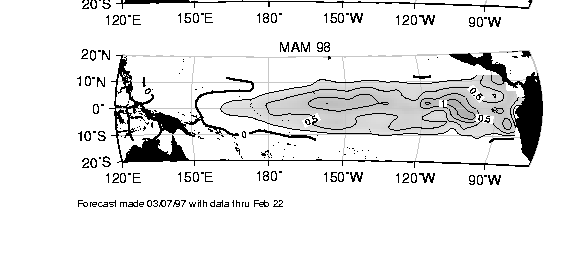
The tropical Pacific version of HCM-3 continues to predict warming through the end of 1997 and
early 1998, as did the last forecast (presented in the December 1996 issue of this Bulletin). The
development of the warm anomaly follows a pattern of starting at the coast of South America and
subsequently expanding westward past the dateline. Compared to the last forecast, the current
forecast is showing slightly larger peak anomalies, but otherwise is quite similar. Note that
because of the manner in which the HCM-3 is initialized, the magnitude of the warming may be
underestimated in the model.
Caveat: The forecasts shown above are experimental in nature. The reader is forewarned that the
methods/forecasts are new and subject to future change and improvement.
Acknowledgment: This work is supported by NOAA and the National Science Foundation's
Climate Dynamics Division.
Barnett, T.P., M. Latif, N. Graham, M. Flugel, S. Pazan and W. White, 1993: ENSO and
ENSO-related predictability: Part 1 - Prediction of equatorial Pacific sea surface temperatures
with a hybrid coupled ocean-atmosphere model. J. Climate, 6, 1545-1566.
Da Silva, A.M., C.C.Young and S. Levitus, 1994: Atlas of surface marine data 1994, Vol. 1:
Algorithms and procedures. NOAA Atlas NESDIS 6, U.S. Department of Commerce, 83 pp.
Goldenberg, S.D. and J.J. O'Brien, 1981: Time and space variability of tropical Pacific wind
stress. Mon. Wea. Rev., 109, 1190-1207.
Latif, M., 1987: Tropical ocean circulation experiments. J. Phys. Oceanogr., 17, 246-263.
Pacanowski, R.C. and S.G.H. Philander, 1981: Parameterization of vertical mixing in numerical
models of tropical oceans. J. Phys. Oceanogr., 11, 1443-1451.
Pierce, D., J. Ritchie and T.P. Barnett, 1997: An improved hybrid coupled model for tropical
SST prediction. In preparation.
Wolff, J.-O. And E Maier-Reimer, 1992: HOPE, the Hamburg ocean primitive equation model.
81 pp. Available from Max Planck Institut fur Meteorologie, Hamburg, Germany.
Fig. 1. Scripps/MPI hybrid coupled model (HCM-3) forecast of the field of tropical Pacific SST
anomaly (oC) for JJA and SON 1997, DJF 1997-98, and MAM 1998. Observed data up to
February 22 1997 are used. Contour interval 0.25oC.