One objective of the European PROVOST experiment (PRediction Of climate Variations On Seasonal and interannual Timescales) is to estimate potential dynamical seasonal predictability given ideal surface boundary conditions on a global scale. To this end, three European models (the UKMO Unified Model at climate resolution, the ECMWF T63 model and the ARPGE model run at T42 by Météo-France and T63 by EDF) have been integrated in 9-member ensembles for four months for each season over 15 years from 1979 to 1993 (climatologies are calculated over the same period). The integrations used observed SST anomalies from the UKMO GISST and Reynolds' OI data sets. Atmospheric initial conditions for the ensemble were provided by 0000Z analyses, from the ECMWF reanalysis, on the nine days prior to the start of the season. Useful levels of skill appear to exist in these PROVOST simulations for the region of East Africa between 10N and 10S and, based on these assessments, a real-time Short Rains forecast at one month lead is provided in this paper.
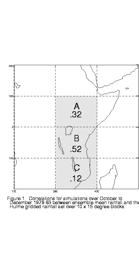
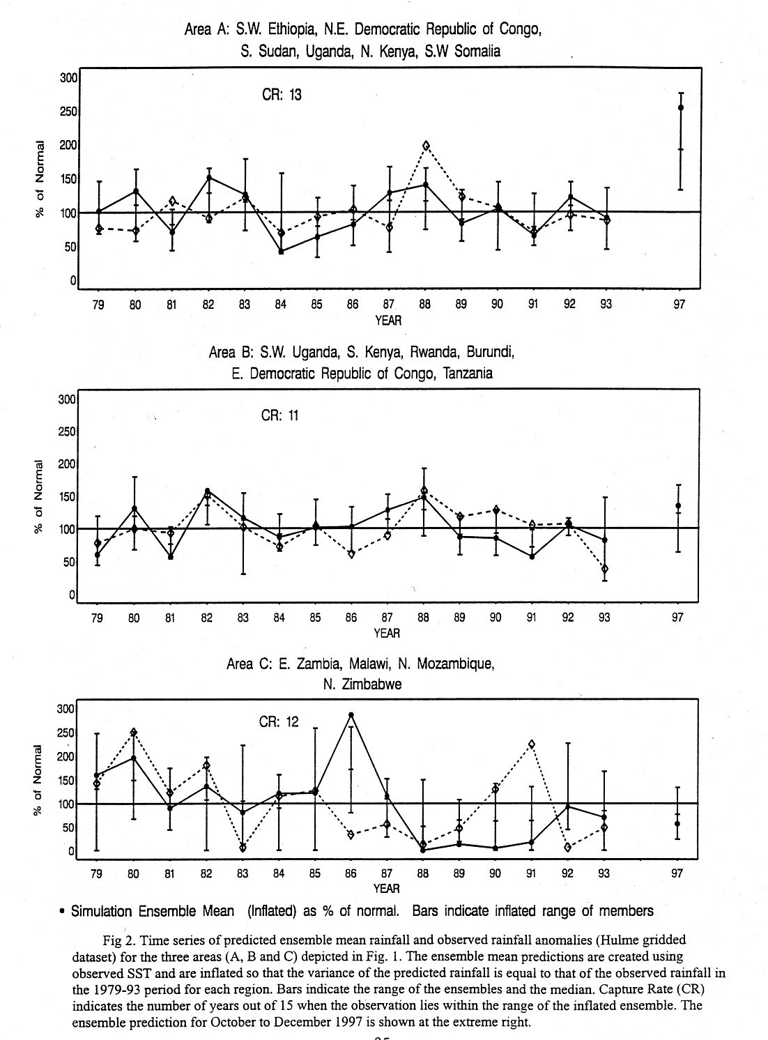
Correlations between October to December (Oct-Nov-Dec) ensemble-mean rainfall anomalies and observed anomaly values over 15 years, obtained from the gridded observed land-surface rainfall data set of Hulme (1994) have been calculated for three 10 latitude bands between 10N and 20S, bound by longitudes 28 and 43E (Fig. 1). The highest correla-tion (0.52) occurs for Band (B), centered on Tanzania. For the northern Band (A), covering southern Sudan and Ethiopia, northern Kenya and Uganda and north-eastern Democratic Republic of Congo, the correlation is 0.32. Lower model skill (correlation of 0.12) is indicated for the southernmost Band (C). The observed data set is gridded to the same resolution as the model (2 latitude x 3 longitude), but in order to reduce noise 4 x 4 blocks have been joined together to produce Fig. 1; only blocks with adequate data were retained. Time series of ensemble mean rainfall and the Hulme data indicate that the dynamical model, although able to capture the interannual variability reasonably well, has insufficient variability. Hence a variance inflation has been calculated using both ensemble means and ensemble members for each gridded area and applied appropriately to the forecasts from both the members and the ensemble means. In most years the observed anomaly lies within (or is "captured" by) the range of the inflated ensemble, or is a close outlier to the range (Fig. 2). The capture rates (out of 15) for areas A, B and C are respectively 13, 11 and 12.
Forecasts for the 1997 Oct-Nov-Dec season are derived from nine-member ensemble runs, but with the difference from the PROVOST runs that persisted SST anomalies (from August), rather than observed values, are used throughout. It is thought unlikely that the use of persisted anomalies will have a significant negative impact if results obtained from experiments for twelve Northern Hemisphere winter seasons, carried out with persisted November anomalies, can be extrapolated to the October to December Short Rains season. While there is some inevitable loss of predictability associated with the use of persisted anomalies, this appears to be minimal in areas of relatively high predictability such as considered here, and certainly does not eliminate predictability in terms of the levels normally associated with seasonal forecasts (see Harrison et al., 1997). Use of persisted anomalies fails, of course, during seasons in which there is a substantial readjustment of SST anomalies over ocean areas related to a given region's rainfall. Currently there is no solution to this problem of rapid intraseasonal SST anomaly distribution changes: the forecasts given below are conditional on the continuity of the August anomalies.
Above-average rainfall is indicated by all nine ensemble members for Region A, and by eight of the nine members for Region B (Table 1). For Region A the ensemble-mean forecast anomaly is greater than that produced in any of the 15 runs for past years using observed SST (Fig. 2). As the prediction exceeds the apparent range of the model climatology, no confidence should be placed on the absolute value of the predicted anomaly. In contrast, the ensemble-mean predicts below average rainfall for Region C. However, because of the lower skill, particular caution must be exercised in interpreting the forecast for this region: Although the model skill for region C is lower than that for regions A and B (Fig. 1), note that the predicted variability follows the observed variability over parts of the 15 year sequence (Fig. 2) and the capture rate is commensurate with that of Regions A and B.
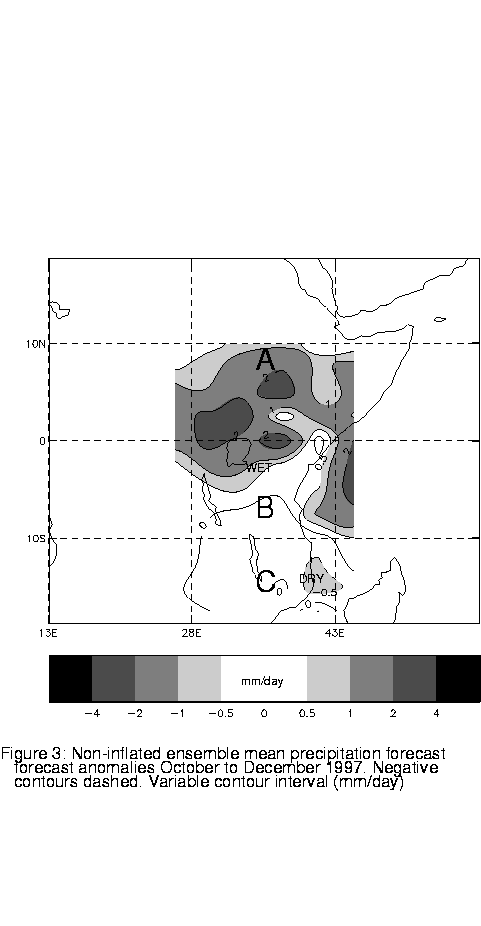
The ensemble-mean forecast anomaly map (Fig. 3) suggests that the above average rainfall in regions A and B is accompanied by dry or normal conditions in region C. Although the location of the transition zone from wet to dry anomaly is uncertain (recall that skill is lower in region C than in A and B), the anomaly pattern is consistent with the expected impact, based on previous experience, from the current El Niño conditions.
In summary, the method described indicates that the East African Short Rains are likely to be above average in Regions A and B and below average in region C. Confidence is relatively high for Regions A and B and relatively low for Region C.
Harrison, M. et al., 1997: A dynamical one-month lead seasonal rainfall prediction for March to May 1997 for the north-eastern area of South America, Experi-mental Long-Lead Bulletin, NOAA, 6, June 1997, 25-28.
Hulme, M., 1994: Validation of large-scale precipitation fields in general
circulation models. Global Precipitation and Climate Change, M. Desbois
and F. Desalmand, Eds., NATO ASI Series, Vol. 23, Springer-Verlag, 387-406.
Table 1. October to December 1997 seasonal forecast rainfall percentages
of normal for the Ensemble Mean (E Mean), inflated ensemble mean (I Mean),
the wettest and driest (inflated) ensemble members, and the number of members
(out of 9) giving more than 100% of normal rainfall. Results are for the
3 Regions A and B and C (see Fig. 1).
|
|
A | B | C |
| E Mean (%) | 140 | 110 | 94 |
| I Mean (%) | 255 | 134 | 56 |
| I Wettest (%) | 276 | 166 | 134 |
| I Driest (%) | 133 | 63 | 23 |
| No.Runs >100% | 9 | 8 | 2 |
Fig. 1. Correlations for simulations for Oct-Nov-Dec 1979-93 between ensemble mean rainfall and the Hulme gridded rainfall set over 10 x 15 blocks.
Figure 2. Time series of predicted ensemble mean rainfall and observed rainfall anomalies (Hulme gridded dataset) for the areas depicted in Figure 1. The ensemble mean predictions are created using observed SST and are inflated so that the variance of the predicted rainfall is equal to that of the observed rainfall in the 1979-93 period for each region. Bars indicate the range of the ensembles and the median. Capture Rate (CR) indicates the number of years out of 15 when the observation lies within the range of the inflated ensemble. Results are for the 3 Regions A and B and C (see Fig. 1). The ensemble prediction for October to December 1997 is shown at the extreme right.
Fig. 3. Non-inflated ensemble mean precipitation
forecast anomalies for October to December 1997. Negative contours dashed.
Variable contour interval (mm/day).