Rainfall in Uruguay (30-35S, 54-58W; see Fig. 1) occurs during the 12 months of the year. Mid-latitude fronts reach this subtropical region especially during winter and also fall and spring. Convective rainfalls affect the country during summer but also spring and fall seasons, especially in the North and/or Northwest (continentally influenced) part of Uruguay. The complex interaction of several rainfall mechanisms generators produces a wet climate with a "flat" annual cycle of precipitation. This is the case especially in the southern part of Uruguay, influenced by the Río de la Plata and the Atlantic Ocean. In the northern part, fall and spring average rainfall exceeds that of winter and summer (Pisciottano et al. 1994).
In spite of this complex climatic situation, studies have confirmed a significant influence of the ENSO on Uruguay's interannual rainfall variability, with a tendency for above normal rainfall during warm Pacific events, especially in November and December when the event is near its mature phase (Ropelewski and Halpert 1987; Aceituno 1988; Pisciottano et al. 1994; Díaz et al. 1997). Mechanisms explaining this association have to do with changes in the subtropical southern westerlies. The location (e.g. N-S position, exits region), structure, intensity and other features of this anomalous jet stream determine both the baroclinic developments and the probability of convective events in southeastern South America where Uruguay is located. Cazes et al. (1996) showed that changes in circulation and precipitation patterns affecting Uruguay, in November of a Pacific warm event, can be simulated through an AGCM and well compared with adequate composites of past events.
Diagnostic studies have also revealed that: (1) There is a significant tendency for less than normal precipitation in Uruguay during La Niña episodes, especially from October to December; (2) A relationship between Pacific SST (indices or fields) and precipitation in Uruguay that show some real skill on seasonal (bimonthly to quarterly) time scales (Diaz and Studinski 1995; Cazes et al. 1994; (3) Methods based on canonical correlation analysis (CCA) show the greatest skill for the seasons around November, for regions comprising Uruguay when Pacific SST are related to either the Uruguay-Rio Grande do Sul precipitation field or subtropical South America precip-itation (including central Chile) (Diaz and Studzinski 1995; Montecinos et al. 1996; (4) Statistically, the best diagnostic relationships are the simultaneous ones; by using forecasted SSTs we can use this to forecast Nov-Dec 1997 rainfall in Uruguay; (5) Zero or one month lead/lag between the SST "predictor" and the seasonal precipitation yield similar "cross-validated" relationship strengths (Diaz and Studzinski 1995; Pisci-ottano et al. 1994; Cazes et al. 1994); thus for short lead times (up to 2-months) we do not need to use fore-casted SST values; probably due to the slow timescales of the ocean rather than the atmospheric response.
For diagnostic studies and for results presented here, we use a long time series of monthly values of the "Index of Wright" (IW) of SST anomalies in the central tropical Pacific (ºC X100; Wright 1989). The region is similar to Niño 3 but a long time series is available for diagnostic studies. Values from 1987 to 1994 were calculated by averaging NOAA monthly gridded SST data over the Wright region. The correlations between Niño 3 and IW are larger than .91 for every month (using 1950s-1980s data). A reconstruction of the IW via a linear regression for the 90s gives similar values to those obtained by averaging gridded data. We also reconstructed values of the past months of this year, to be used as "predictors" (Table 1).
Table 1. Recent values of the IW SST index of Wright (C X100); last value is an average for Jun-Jul-Aug.
| Jan | Feb | Mar | Apr | May | Jun | Jul | Aug | JJA | |
| IW | -58 | -23 | 17 | 38 | 112 | 168 | 203 | 242 | 204 |
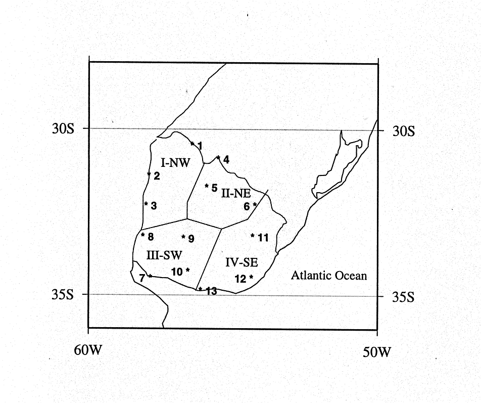
Our precipitation data are monthly values (mm) from 13 rainfall stations in Uruguay (Fig. 1). The data come from the Dirección Nacional de Meteorología (DNM) -- Uruguay. These data go to the WMO data network and are available on-line. For diagnostic and prediction purposes we have grouped the stations into four regions (Fig. 1). For each region, we calculated a monthly regional precipitation value for each month in the common period spanned by the records of stations included in the respective region. There are no gaps for these periods, and no "filling-blanks" procedures were used. Bimonthly time series for November-December are formed from the monthly values.
We defined fixed equiprobable categories of the predicted variable ("above"/"normal"/"below" terciles, quartiles, quints). Changes in the probabilities given a specific climatic event (e.g. an ENSO event) are calculated for each category and used to form a probabilistic prediction. First the statistical distributional parameters (first quartile, median, and third quartile--called qcl, mcl and Qcl) for all years are determined for November-December regional precipitation. These statistics characterize the rainfall climatology (cl) of the respective region. In the absence of any climate-determining information, a value of "around mcl" is expected and the interval (qcl, Qcl) has a large (50%) chance of containing the real observed value. In this case the "forecast" would be mcl and an "error bar" would be (qcl, Qcl); see Table 2.
To incorporate the knowledge provided by the ENSO-rainfall relationships, we stratify the population based on 3 categories of the IW SST index. We define a "critical value", IWcr, and obtain a "subpopulation" of November-December regional precipitation from only years for which the June-July-August mean IW>IWcr (making it a "warm" year, or w), IW<-IWcr ("cold" year, or c), or -Iwcr<IW<IWcr ("close to normal" year, or n). In agreement with former studies, we find that in the subpopulation of "warm" (w) years there is tendency for enhanced rainfall. We test this statistical tendency with a hypergeometric distribution using the frequencies of above and below normal rainfall in the population versus the frequencies for the "warm" subpopulation. The Statistical significance (in the sense of Ropelewski and Halpert 1987; Pisciottano et al. 1994; Cazes et al. 1994; for the critical value of IWcr=50, exceeds 99%. We note a balance between the "intensity" of a required event (as prescribed by IWcr) and the statistical significance of the rainfall differences. A very large IWcr produces a small number of events, yielding a lower significance than a moderate IWcr. It is found that IWcr=50 results in close to the highest significance, although IWcr=70 also works well (significance > 99%) in 3 of the 4 regions used (Fig. 1).
Using Iwcr=50, we calculate the statistical parameters (q, m and Q) for a season (in this case Nov-Dec) for regions I to IV, for each of the subpopulations (w, n and c); see Table 2. The procedure is similar to that used by Ropelewski and Halpert (1996).
Table 3 illustrates the rainfall distribution shift associated with "warm" years (IW>50) with frequencies of occurrence of each of the four quartiles for each of the four regions.
Table 2. For each region (columns): data period (years); period length (N); size of the warm (Nw), normal (Nn) and cold (Nc) subpopulations; Q, m, q, denote upper quartile, median and lower quartile; cl= climatological; w=warm, n=normal, c=cold.
| Region | I - NW | II - NE | III- SW |
|
| Period | 1931-92 | 1914-92 | 1914-92 | 1915-92 |
| all: N | 62 | 79 | 79 | 78 |
| warm: Nw | 13 | 16 | 16 | 15 |
| normal: Nn | 37 | 49 | 49 | 49 |
| cold: Nc | 12 | 14 | 14 | 14 |
| all: Qcl | 267 | 251 | 210 | 185 |
| all: mcl | 202 | 184 | 147 | 133 |
| all: qcl | 138 | 109 | 99 | 99 |
| warm: Qw | 336 | 294 | 286 | 226 |
| warm: mw | 270 | 244 | 187 | 155 |
| warm: qw | 220 | 218 | 159 | 130 |
| normal: Qn | 261 | 244 | 212 | 182 |
| normal: mn | 198 | 174 | 145 | 124 |
| normal: qn | 126 | 98 | 94 | 90 |
| cold: Qc | 202 | 182 | 143 | 162 |
| cold: mc | 159 | 136 | 127 | 115 |
| cold: qc | 138 | 80 | 73 | 100 |
Table 3. Frequencies of occurrence of rainfalls in each of the 4 quartiles of the climatological distribution, given a "warm" year (IW>50), for each of the four regions in Uruguay.
| I--NW | II-NE | III-SW | IV-SE | |
| Nw |
|
16 | 16 | 15 |
| N1(%) | 0 (0%) | 0 (0%) | 1 (6%) | 1 (7%) |
| N2(%) | 3 (23%) | 1 (6%) | 2 (13%) | 2 (13%) |
| N3(%) | 5 (38%) | 8 (50%) | 8 (50%) | 6 (40%) |
| N4(%) | 5 (38%) | 7 (44%) | 5 (31%) | 6 (40%) |
These results enable us to "predict" the expected precipitation, based on which of the three subpopu-lations into which we place the Pacific SST anomaly (IW). The "prediction" is the median of the respective subpopulation (mw, mn or mc; rather than the climat-ology mcl). The interval (q, Q) from the appropriate subpopulation is the "error bar" of the prediction. This technique circumvents problems associated with the nonlinearities of the SST - rainfall relationships and skewness of the rainfall distributions, and has been used during the past several years to experimentally predict rainfall in Uruguay. For example, in 1996 a version of the technique predicted rainfall in three regions of Uruguay for November 1996 to February 1997 reasonably well. This forecast was used by rice growers for water resource management (Pisciottano and Diaz, 1997; Cabral and Pisciottano 1997).
Based on the currents values of the Pacific SST anomalies (Table 1) and the distributional shifts discussed above, we issue the following rainfall predictions for the November-December 1997 period for each region in Uruguay.
Region I-NW Uruguay: A value around ("~")270 mm of rainfall is expected, with 50% chance of between 220 and 336 mm. The probabilities of rainfall in the 3rd and the 4th quartile of the climatological distribution are 38% and 38%, respectively; and of rainfall above the median (202 mm) is 76%.
Region II-NE Uruguay: ~244 mm is expected, with 50% chance of between 218 and 294 mm. The climatological 3rd quartile and 4th quartile have probabilities of 50% and 44%, respectively; and of rainfall above the median (184 mm) is 94%.
Region III-SW Uruguay: ~187 mm is expected, with 50% chance of between 159 and 286 mm. The climatological 3rd quartile and 4th quartile have probabilities of 50% and 31%, respectively; and of rainfall above the median (147 mm) is 81%.
Region IV-SE Uruguay: ~155 mm is expected, with 50% chance of between 130 and 226 mm. The climatological 3rd quartile and 4th quartile have probabilities of 40% and 40%; and of rainfall above the median (133 mm) is 80%.
In summary, a wetter than normal November- December period is expected this year in Uruguay, with probabilities of above median precipitation ranging from 76% to 94%, depending on region.
Aceituno, P., 1988: On the functioning of the Southern Oscillation in the South American sector. Mon. Wea. Rev., 116, 505-525.
Cabral, A. and G. Pisciottano, 1997: Elementos para entender el fenómeno 'El Niño' y sus aplicaciones en la agricultura. Revista de la Asociación de Cultivadores de Arroz del Uruguay. Junio 1997, 32-42.
Cazes, G., J. L. Genta and G. Pisciottano, 1994: Generación de información hidrológicamente relevante a partir de información y diagnóstico climático. Aplica-ción en Uruguay. Memorias XVI Congreso Latino-americano de Hidráulica, Santiago, Chile, 3, 121-127.
Cazes, G., G. Pisciottano and R. Terra, 1996: Var-iabilidad climática en el sudeste de Sud América y pat-rones de circulación anómalos en Noviembre. Simu-lación con un modelo de circulación general de la at-mósfera. Memorias del VII Congreso Latinoamericano e Ibérico de Meteorología. Buenos Aires, Argen-tina.
delo de circulación general de la atmósfera. Memorias del VII Congreso Latinoamericano e Ibérico de Meteorología. Buenos Aires, Argentina.
Díaz, A. and Studzinski, 1994: Rainfall forecast in Uruguay and southern Brazil using canonical correlation analysis. Memorias del II Congreso Congreso Latinoamericano e Ibérico de Meteorología. Belo Horizonte, Brazil.
Díaz, A., C. Studzinski and C. R. Mechoso, 1997: Relationships between precipitation anomalies in Uruguay and southern Brazil and sea surface temperature in the Pacific and Atlantic oceans. Journal of Climate, 9, accepted.
Ropelewski, C.F., and M.S. Halpert, 1996: Quantifying Southern Oscillation-precipitation rela-tionships. J. Climate, 9, 1043-1959.
Montecinos, A., A. Diaz and P. Aceituno, 1996: Predictabilidad de la precipitación en la región subtropical de América del Sur, basada en la temperatura superficial del mar en el océano Pacífico. Memorias del VII Congreso Latinoamericano e Ibérico de Meteorología. Buenos Aires, Argentina.
Pisciottano, G., A. Díaz, G. Cazes and C.R. Mechoso, 1994: El Nino-Southern Oscillation impact on rainfall in Uruguay. J. Climate, 7, 1286-1302.
Pisciottano, G. and A. Diaz, 1997: Diagnóstico y predicción climática en Uruguay. Memorias del Taller "Variabilidad climática interanual: métodos de pronóstico e impactos asociados". Santiago, Chile.
Ropelewski, C.F., and M.S. Halpert, 1987: Global and regional scale precipitation patterns associated with the El Niño/Southern Oscillation. Mon. Wea. Rev., 115, 1606-1626.
Wright, P. 1989: Homogenized long-period Southern Oscillation Indices. Int. J. of Climatol., 9, 34-54.
Fig.1. The 13 rainfall stations used in this
study and the 4 regions in Uruguay. Stations: 1 Artigas; 2 Salto; 3 Paysandu;
4 Rivera; 5 Tacuarembo; 6 Melo; 7 Colonia; 8 Mercedes; 9 Trinidad; 10 San
Jose; 11 Treinta y Tres; 12 Rocha; 13 Montevideo. Regions: I-NW, Northwest;
II-NE, Northeast; III-SW, Southwest; IV-SE, Southeast.