HOME> Expert Assessments>Hazards Outlook
For 3-7 day hazards see Weather Prediction Center's: WPC 3-7 Day Hazards
U.S. Week-2 Hazards Outlook - Made July 03, 2025 | About the Hazards Outlook
| Categorical Outlooks Day 8-14 |
Experimental Probabilistic Outlooks |
 |
Valid Friday July 11, 2025 to Thursday July 17, 2025
US Hazards OutlookNWS Climate Prediction Center College Park MD
300 PM EDT July 03 2025
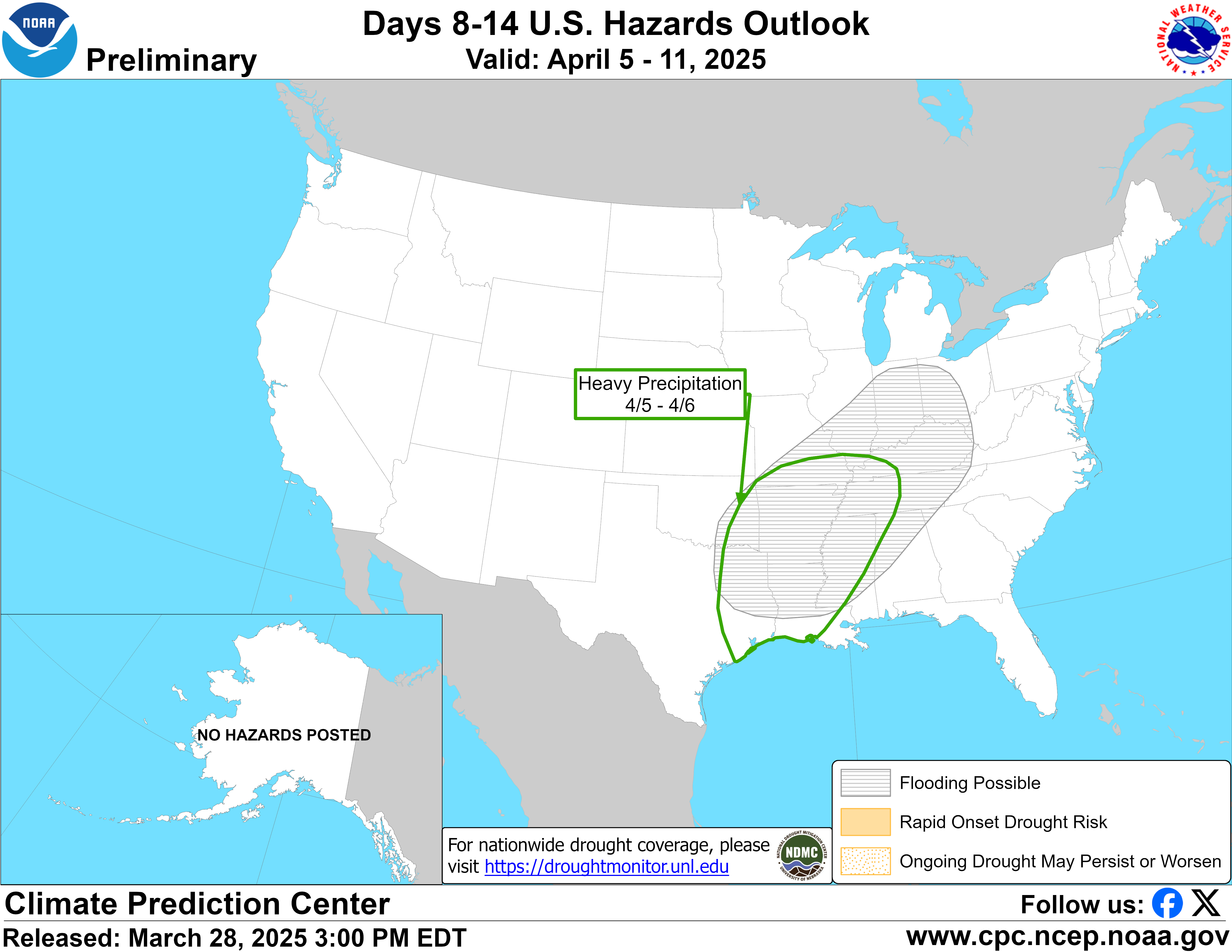
Synopsis: An increased risk for extreme heat is forecast across the West at the beginning of week-2, but chances decrease later in the outlook period as the mid-level ridge of high pressure weakens. Only a slight risk of heavy precipitation is posted for southeastern Arizona and southwestern New Mexico due to diverging model solutions. On July 11 and 12, a slow-moving front is forecast to be the focus for thunderstorms with locally heavy rainfall from the Mid-Atlantic west to the Tennessee Valley.
Hazards
- Moderate risk of extreme heat for the Desert Southwest and San Joaquin Valley of California, Fri, Jul 11.
- Slight risk of extreme heat for parts of the West, Fri-Sat, Jul 11-12.
- Slight risk of heavy precipitation for southeastern Arizona and southwestern New Mexico, Fri-Thu, Jul 11-17.
- Slight risk of heavy precipitation for parts of the eastern U.S., Thu-Sat, Jul 10-12.
For Sunday July 06 - Thursday July 10: WPC Days 3-7 U.S. Hazards
For Friday July 11 - Thursday July 17: The GEFS and ECENS depict a 500-hPa ridge strengthening over the West during the early to middle part of next week. These ensemble mean solutions remain consistent that this ridge peaks in strength on day 7 (July 10) when 500-hPa heights reach 597-dam across southern California and the Southwest. Thereafter, a shortwave trough is expected to move inland from the northeastern Pacific and suppress the longwave ridge over the West. A moderate risk of extreme heat, valid July 11, is only posted for the San Joaquin Valley where the GEFS and ECMWF Probabilistic Extremes Tools (PETs) have near a 40 percent chance of maximum temperatures exceeding the 85th percentile and 100 degrees F. The moderate risk was discontinued for the Desert Southwest due to: slightly lower 500-hPa heights among the ensemble means by July 11 and less than a 40 percent chance that maximum temperatures reach 110 degrees F according to the PETs. Although above-normal temperatures are likely to persist throughout much of the West through the end of week-2, a slight risk of extreme heat is valid only through July 12 as chances that maximum temperatures reach extreme heat thresholds decrease to below 20 percent. The anomalous warmth during mid-July would lead to the additional drying of fuels and elevate the wildfire danger across the interior Pacific Northwest and Northern Intermountain West.
Following Hurricane Flossie in the East Pacific, the National Hurricane Center states that there is a 80 percent chance of another tropical cyclone (TC) forming in the East Pacific during the next week. Many of the GEFS ensemble members have this potential TC taking a northwest which could eventually lead to a surge of enhanced low to mid-level moisture northward from the Gulf of California into the Desert Southwest. However, the ECENS ensemble members are generally weaker with any TC that develops and favor a more westward track with enhanced moisture less likely to reach the Desert Southwest. Based on the wetter GEFS PET and also its more favorable 500-hPa ridge axis closer to the Four Corners, a slight risk of heavy precipitation is posted for parts of Arizona and New Mexico.
A slow-moving front is forecast to be the focus for thunderstorms with locally heavy rainfall across the parts of the Mid-Atlantic, Southeast, and Tennessee Valley. The spatial extent of the slight risk of heavy precipitation, valid on July 11 and 12, is generally based on where there are enhanced 24-hour rainfall amounts from the GEFS and ECENS. Beyond the early part of week-2, any diurnal convection is expected to become more scattered across the eastern U.S. which precludes the continuation of the slight risk past July 12.
An amplified 500-hPa trough is forecast to become established over Alaska by the beginning of week-2. This anomalous trough favors much cooler temperatures and above-normal precipitation across much of Alaska. However, precipitation amounts are not forecast to reach hazards thresholds.
Forecaster: Brad Pugh
$$ Please consult local NWS Forecast Offices for short range forecasts and region-specific information.
Resources
Week-2 Probabilistic Extremes Tool
GFS Ensemble Forecasts