This publication monitors current and developing climate variations and is issued as conditions warrant. Questions should be directed as follows:
     Area of Concern	               Source	                          Telephone Number

Current Climate Information  Climate Prediction Center, NWS
	                     Climate Operations Branch	                    (301) 763-4670
	                     Analysis Branch	                            (301) 763-8227
                             Prediction Branch	                            (301) 763-8155
Regional Climate Centers     Northeast RCC                                  (607) 255-5950
                             Southeast RCC                                  (803) 737-0800
                             Midwest RCC                                    (217) 244-1488
                             Southern RCC                                   (504) 388-6184
                             High Plains RCC                                (402) 472-6706
                             Western RCC                                    (702) 677-3103
Public Information	     NWS Public Affairs	                            (301) 713-0622
Historical Perspective	     NESDIS National Climatic Data Center           (704) 271-4800
Water Supply/Forecasts	     NWS Office of Hydrology*	                    (301) 713-1630
Wildfires	             National Interagency Coordination Center       (208) 387-5512
Agriculture	             USDA World Agricultural Outlook Board          (202) 720-3508
	                     USDA National Agricultural Statistics Service  (202) 720-2157
	                     Joint Agricultural Weather Facility	    (202) 720-7917
Drought Planning             National Drought Mitigation Center             (402) 472-6707
*There are 13 National Weather Service River Forecast Offices throughout the U.S. that provide water supply forecasts. Call the above number for the River Forecast Center with responsibility for your area of interest.
The Climate Prediction Center (CPC) provides climate products and services consisting of operational prediction of climate variations, monitoring of the climate system and development of databases for determining current global and regional climate anomalies and trends, and analysis of their origins and linkages to the complete climate system. These services cover climate time-scales ranging from weeks to seasons, extending into the future as far as technically feasible, and over the domain of land, ocean, and atmosphere, extending into the stratosphere.
Services and products are distributed to users in the government, the research community, private industry, and the public, both in this country and abroad. The CPC supports and stimulates the use of climate data for applications in agriculture, energy, transportation, water resources, and health.
To support these services, the CPC engages in diagnostic research and studies of observations and forecast model output to improve the prediction, monitoring, and analysis of the physical climate system.
1. Introduction
The northwestern United States has been inundated by large-scale flooding which peaked in early January 1997 and which caused damages exceeding $1 billion. In general, the classic ingredients for wintertime flooding in the United States are a heavy snowpack over nearly saturated or frozen ground, followed by a rapid warm-up and heavy rain event. The wet and warm weather contributes to significant snow melt, resulting in very large run-off and eventual flooding in a short time. Two other examples of these conditions occurring during the last year are: (1) flooding in the Willamette and Columbia Rivers of the Pacific Northwest in February; and (2) flooding of the Potomac and Susquehana Rivers and their tributaries in the mid-Atlantic states during January 1996.
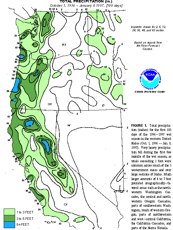
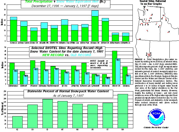
The primary factors contributing to the recent flooding in the Northwest were: (1) repeated above-normal precipitation events since October (Figure 1), (Figure 2) and (Figure 3), which produced saturated soils and above-normal snowpack and snowpack water content throughout the northwest (Figure 4, middle and bottom); and (2) several major storms in late December and early January, which brought substantial moisture and unseasonably mild air from the subtropics well northward into the Pacific Northwest (Figure 5, bottom). These storms produced exceptionally heavy rainfall and caused significant melting of the mid-elevation and low-elevation snowpack (Figure 4, top), resulting in massive run-off and eventual flooding of many of the region's rivers and creeks. This circulation pattern changed after 2 January 1997 as abnormally high pressure and dry conditions moved into the Northwest. Nonetheless, many rivers remained well above flood stage even after several days of little or no precipitation.
The strong storm activity, above-normal precipitation and unusually strong jet stream winds (Figure 6) and (Figure 7) observed across the northwestern United States during November and December 1996 were similar to those observed last winter. The pattern of abnormally dry conditions and weak storm activity across the southwestern United States is also similar to that observed last winter.
2. Northwestern United States Precipitation: 1996-97 wet seasonThe 1996-97 wet season has produced excessive precipitation totals throughout the northwestern United States, including northern California and the Sierra Nevada Range (Figure 1). Many areas in the Pacific Northwest, northern California and the Sierra Nevada have received more than 40 inches of total precipitation since October 1996, with some orographically-favored areas recording in excess of 60 inches. In addition, large portions of coastal central California received more than 30 inches of rain during the period. Farther north and east, excessive precipitation totals also covered Idaho, eastern Washington and eastern Oregon since 1 October, with many areas receiving 1-2 feet of liquid precipitation.
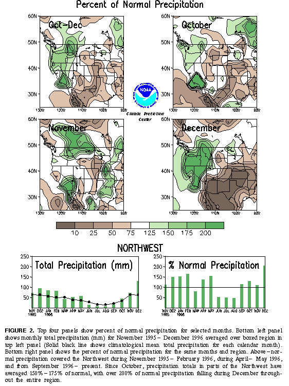
Overall, precipitation totals for the October-December 1996 period exceeded 150% of normal throughout the Northwest (Figure 2a), with the largest departures from normal observed during October and December. During October, totals averaged 125% of normal throughout the Northwest (Figure 2b), following an abnormally wet September. Totals averaged approximately 110% of normal during November (Figure 2c), with the first half of the month being relatively dry and the second half of the month being relatively wet. Very heavy precipitation then inundated the Northwest during December, with totals averaging more than 200% of normal recorded throughout the region (Figure 2d, e, f).
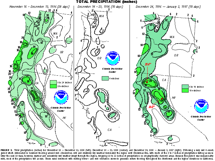
During November and December, much of the heavy precipitation fell in two periods. The first very wet period was 16 Nov.- 13 Dec. (Figure 3 left), which culminated in localized flooding around mid-December. During this period, much of western Oregon and large portions of the Sierra Nevada received inundating precipitation totals of more than 24 inches, while more than 8 inches were recorded throughout the rest of western Oregon, western Washington, and coastal northern and central California. By 13 December, 6-week precipitation totals were 5-10 inches above normal in parts of the northern Sierra Nevada, western Oregon, and portions of northwestern Washington.
Over the next ten days (14-23 December), cooler and relatively dry conditions dominated the Northwest, with the largest precipitation totals (2-4 inches) falling primarily as snow across western Washington, western Oregon and northern and eastern California (Figure 3 middle). This period was followed by a rapid warm-up and a return to extreme precipitation totals during the next ten days (24 December 1996- 2 January 1997), with 18-33 inches of precipitation falling on orographically-favored areas and more than 6 inches falling elsewhere throughout the affected region (Figure 3 right). Due to the extremely warm weather during the period, much of this precipitation fell as rain (Figure 4 top). The wet and warm weather produced significant snowmelt at lower and middle elevations, resulting in severe flooding throughout the Northwest and the higher elevations in California (Figure 4 top). During this period, the equivalent liquid water (rainfall plus snowmelt) available for run-off exceeded 15 inches in many areas, and reached a maximum of 29 inches in Squaw Valley, CA.
3. Snow CoverDespite significant snow melt (2-5 inches of water equivalent) during 27 December 1996 - 2 January 1997, several SNOTEL stations at higher elevations reported record high snowpack water content as of 7 January 1997 (Figure 4 middle). At many sites, the new snowpack water content record exceeded the old record by more than 10 inches. Additionally, statewide-average snowpack water content as of 7 January 1997 exceeded 150% of normal in California, Idaho, Montana, Nevada, Oregon, Utah and Washington (Figure 4 bottom). The largest anomalies were observed in Washington, where snowpack water totals exceeded 225% of normal.
4. CirculationThe circulation features during the above three periods (16 Nov.- 13 Dec., 14-23 Dec. and 24 Dec. 1996- 2. Jan 1997) are shown in Figs. 5-7. The first heavy precipitation period of 16 Nov.- 13 Dec. was characterized by below-normal heights and pressure at upper levels of the atmosphere over southwestern Canada (Figure 5 top left), along with enhanced jet-stream winds averaging 10-15 ms-1 faster than normal across Oregon, northern California and southern Idaho (Figure 6 top). At low levels, abnormally strong southwesterly flow covered the western United States during the period. This flow pattern brought abundant moisture (Figure 6 top) and a series of major storms into the western United States, resulting in heavy precipitation throughout the region.
The subsequent transition to cooler and drier conditions during the 10-day period ending 23 December resulted from the development of strong northwesterly flow at upper levels throughout the northwestern United States (Figure 5 top right) and (Figure 6 middle), and a concurrent drop to below-normal moisture levels throughout the region (Figure 7 middle). This evolution occurred in association with the onset of a strong ridging (referred to as a blocking pattern of high pressure) across the high across the high latitudes of the North Pacific and North Atlantic Ocean basins, and with the formation of an abnormally deep trough of low pressure across central North America (Figure 5 top right). Also during this period, a strong split-flow configuration was evident over the central North Pacific, with a strong subtropical branch of westerlies becoming established to the south of the main ridge.
During the next ten day period ending 2 January 1997, a well-defined Omega-block pattern had become established over the central and eastern North Pacific (Figure 5 bottom). This pattern featured a very strong low-latitude jet stream flow (20-30 ms-1 above normal) south of the mean ridge in the vicinity of Hawaii (Figure 6 bottom) and southwesterly flow at jet stream level extending from the subtropical North Pacific to the northwestern United States. This flow directed a series of major storms into the Northwest, and also brought very warm air and significant moisture from the deep subtropics well into the western United States (Figure 7 bottom).
The pattern also featured a very strong trough over western Canada (Figure 5 bottom), which contributed to abnormally strong northerly flow over the Gulf of Alaska (Figure 6 bottom). This feature combined with the strong subtropical flow stream to produce very strong frontal systems and enhanced frontal-type precipitation across the region, further increasing precipitation totals throughout the region.
5. Causes of the Heavy Precipitation in the NorthwestThe above analysis indicates that heavy precipitation observed in the Northwest during November and December resulted from two essentially distinct flow patterns, each of which brought major storms and moisture from the subtropics into the region. The first pattern was a more east-to-west oriented flow of abnormally strong jet stream across the Northwest, which directed a series of major storms through the region. The second pattern featured a strongly blocked flow at high latitudes of the North Pacific Ocean, and an extremely strong low-latitude flow stream emanating from the subtropical North Pacific and extending directly into the northwestern United States.
A large component of these circulation features reflects the normal highly variable nature typical of the wintertime atmospheric circulation. One important component of this variability in the last few months is high- latitude blocking across the Northern Hemisphere, which contributed significantly to large-amplitude, low-frequency swings in temperature and precipitation in regions such as North America and Europe.
The enhanced variability in the atmospheric circulation over the eastern North Pacific Ocean and the northwestern United States during the past few months is also related to intense Madden-Julian Oscillations (MJO) across the western tropical Pacific. Typically, strong MJO's feature an eastward shift of enhanced tropical convection from the Indian Ocean to the western Pacific, which is accompanied within 5 to 10 days by a strengthening and eastward extension of the jet stream over the middle latitudes of the North Pacific. Satellite imagery confirmed that the recent spell of heavy precipitation and flooding in the Northwest that began in late December was directly related to an abnormally strong southwesterly flow of warm, moist air that extended from the western tropical Pacific to the west coast of North America (Figure 7 bottom). This flow was strongly connected to the enhanced tropical convection associated with the MJO.