|
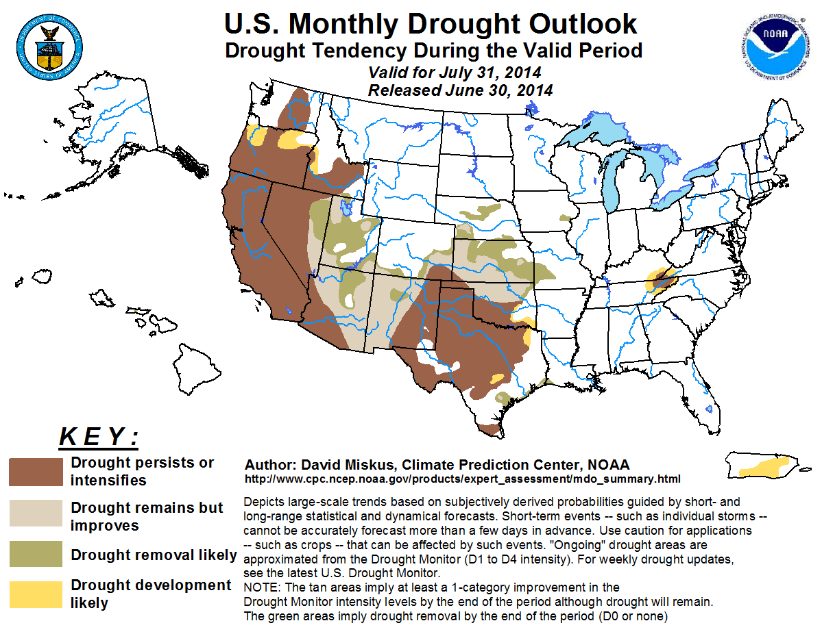
Latest Monthly Assessment -
The Monthly Drought Outlook for July is based on initial conditions, climatology, an expected El Niño event, and
precipitation forecasts on time scales ranging from the next 5 or 7 days (from the Weather Prediction Center) to the 6-10 day,
8-14 day, and updated July Monthly Outlooks issued by the Climate Prediction Center. Drought is expected to persist or worsen
in the Far West (July is normally dry and warm) where large sections are in D3 or D4 drought, and potentially develop in parts
of Oregon where decent odds for above-normal temperatures are forecast in the short, medium, and monthly time scales. In
contrast, an expected robust Southwest monsoon in the southern Rockies (where July is normally one of the wettest months) and
eastern Great Basin is expected to show some drought improvement by the end of the month. In the central Plains, recent heavy
rains and short-term forecasts favor additional improvement or removal in eastern Colorado, Kansas, Nebraska, northern
Oklahoma, and western Missouri. Heavy rains along the western Gulf Coast after the June 24 Drought Monitor, plus chances for
more rain in early July, should be enough to improve drought there. A small area of D1 in eastern Iowa should also disappear
by July 31 as heavy rains are expected during the next week. Drought should mostly persist in the southern Plains (eastern New
Mexico and Texas), although some scattered monsoonal showers could dampen the western and northern edges, while modest drought
expansion is forecast in northeastern Texas and southeastern Oklahoma that are already abnormally dry (D0), have 60- to 90-day
deficits, and the monthly forecast favors below-normal July rainfall. Elsewhere, a mixed signal of forecasts (5-, 7-, 8-14
days favor near or above-normal precipitation, 6-10 day and monthly tilt toward sub-median rainfall) makes for difficult
drought forecasting, but growing short-term D0 and precipitation that have been underwhelming as compared to the forecasts is
expected to expand drought in the south-central Appalachians. Outside the lower 48 States, drought removal is expected in
central Molokai where both July and JAS odds tilt toward above-median rainfall. Drought development is predicted for central
Puerto Rico where abnormal dryness already exists, and an expected El Niño portends a quiet (below-normal convection
and rainfall) Atlantic and Caribbean tropical season.
|
|
Tools used in the U.S. Monthly Drought Outlook (MDO) included the official Climate Prediction Center (CPC) updated
temperature and precipitation outlooks for July 2014, various short- and medium-range forecasts and models such as
the 5-day and 7-day precipitation totals from the Weather Prediction Center, the 6-10 day and 8-14 day CPC forecasts,
the NAEFS precipitation outlooks, the soil moisture tools based on the Constructed Analog on Soil (CAS) moisture, dynamical
models (CFSv2, NMME, IMME, and IRI), the 384-hour total precipitation forecasts from several runs of the GFS, climatology,
historic modeled soil moisture changes during the month, June 24-30 observed precipitation (not included in the June 24
Drought Monitor analysis), and initial conditions.
Climatologically, July (and summer) is a very dry and warm month along the West Coast, especially in California and
Oregon except for extreme southeastern California (southwest monsoon moisture). On average, most of both states receive
less than 2 percent of its annual rainfall during this month. In Washington, this climatological average is closer to 3
percent, but in either case, even the wettest Julys won’t make up for significantly below normal precipitation
accumulated from the prior cold season. In addition, little or no precipitation is forecast for the first half of the
month region-wide, except in eastern Nevada and southeastern California (via the ERFs and monthly outlooks). Any rain
that falls on the latter areas would initially be negated by high temperatures and evaporation, but if continued over a
longer time period (e.g. JAS), some improvement would be possible. Add the large tilt toward above-normal temperatures in the short, medium, and monthly periods, and the odds are overwhelming for drought to persist and perhaps worsen in spots. This includes possible development in parts of northern Oregon that are already in D0 and have 1-3 inch deficits at 30- and 60-days.
Forecast confidence for the Far West is very high, and high in the Pacific Northwest.
Across the northern half of the Intermountain West (including the northern half of the Great Basin), July and August are
the driest months of the year, but not quite as dry as most of California. However, because of the temperature and
humidity this time of year, modeled soil moisture declines over 75 percent during July in more than 90% of the
observations (based on 1932-2011). With both short, medium, and monthly forecasts favoring above-normal temperatures,
and outlooks for the first half of July expecting little or no rain (equal chances for monthly), the consensus of
indicators point to little chance for drought relief, although climatologically the odds slightly increase in areas
farther south and east.
Forecast confidence for the northern half of the Intermountain West is high.
July normally marks a rapid transition from dry (May-June) to wet time of year across the southern half of the
Intermountain West and in the southern Rockies. This is most obvious in Arizona, southern Nevada, and western New
Mexico where June usually brings less than 2% of annual precipitation, but July can bring up to 25% (southern Arizona).
The modeled soil moisture also increases in Arizona and New Mexico during July, so any forecast for above-median
precipitation can bring drought relief. The 5- and 7-day forecasts call for little or no precipitation through the first
week of July, but the odds increase for above-normal rainfall through the second week of the month, as well as the
monthly precipitation outlook. With an expected robust southwestern monsoon (including above-normal sea surface
temperatures surrounding Baja California, an active eastern Pacific tropical season – which is already off to a fast
start, and an anticipated El Niño event), some improvement (or removal for D1 areas) can be expected in the eastern
sections of the southern Intermountain West and western sections of the southern Rockies as Pacific & Mexican moisture
should start flowing into this region during July. The only concern is if the northward moisture fetch is delayed until
late in the month – which would diminish chances for improvement (hence the medium confidence). In addition, due to the
scattered nature of the monsoon, not all areas will see drought-breaking rains, but many should. Western areas of the
southern Intermountain West have lower chances for above-median medium (ERF) and monthly precipitation, hence the
persistence here. In eastern New Mexico and southwestern Texas, although some forecasts are predicting or favoring
above-median rainfall during July, most of the drought’s impacts are long-term, requiring an extended period of wet
weather to reduce these impacts. Because of this, persistence was kept in this region for July, but not in the JAS
Seasonal Drought Outlook where expected above-median rainfall should improve long-term drought by the end of September.
Forecast confidence for the southern half of the Intermountain West and the southern Rockies is medium to high.
July is somewhat drier than May and June in the south-central Plains (southern Oklahoma and northern Texas). The
short-term forecasts predict 1-2 inches of rain across northern Texas and western Oklahoma during the first week of
July but dry to the south, with near to above-normal amounts expected during the second week of July (although some
medium-range models indicate dry weather over Texas). Furthermore, the monthly odds favor neither above nor below median
rainfall (equal chances). With subnormal July rainfall favored to the east (central Gulf to central Appalachians) and
above-median monthly precipitation expected to the west (active southwest monsoon), the lack of clear-cut outlooks
parlay into a low confidence forecast. With the convective nature of summer precipitation, there will probably be some
parts of the region that receive heavy precipitation and drought relief, but the overall indicators slightly lean toward
subnormal rainfall and drought persistence to be the general rule across the region.
Forecast confidence for southern Plains is low to moderate.
Heavy rains fell on most of the central Plains and western Corn Belt after the June 24 Drought Monitor cut-off time
(during June 24-29), continuing a wet trend since the spring in both of these regions. Although the short- and
medium-term forecasts are more scattered in nature for where decent rain is most-likely to occur (south-central Plains
and Iowa), the monthly (equal chances) and seasonal (slight tilt toward above-median rainfall) outlooks, favorable odds
for sub-median temperatures at all time periods, and initial conditions point toward favorable soil moisture, hence the
improvement forecast in the central Plains and Midwest (eastern Iowa). The highest forecast confidence is for areas in
the north and east, and somewhat lower in southern and western sections.
Forecast confidence for the central Plains and Midwest is moderate to high.
For the small area of drought in the south-central Appalachians (southeastern Kentucky, northeastern Tennessee, and
southwestern Virginia), differing solutions in the forecasts (5-, 7-, and 6-10 day near-normal, 8-14 day above-normal,
and monthly forecast below normal precipitation) leave confidence levels low. However, because it is difficult to boost
modeled soil moisture during the month of July climatologically (increased temperatures and evapotranspiration), and
since recent observed rainfall has been less than what the models have forecast, it seems somewhat more likely than not
that the moderate drought (D1) in the region will persist, and that part of the surrounding D0 will deteriorate into
drought by the end of July.
Forecast confidence for the south-central Appalachians is low.
A small moderate drought area persists on central Molokai in Hawaii, associated with low water levels on the Kualapuu
Reservoir. The July 2014 forecast (as well as JAS) is for a slight tilt toward above-median rainfall, so if July does
verify as a wet month, it should help raise the reservoir level enough to put central Molokai from D1 to at least D0 by
July 31. This wet pattern in the eastern and central Pacific is forecast from the expected El Niño event, whereas the
opposite holds true in the Caribbean and central Atlantic basins (see below).
Forecast confidence for Hawaii is moderate to high.
Abnormal dryness (D0 on the Drought Monitor) has developed and expanded recently in central and eastern Puerto Rico.
Deficits have accumulated (3-6 inches at 30-days; 6-12 inches at 90-days), USGS average stream flows have diminished,
and below-normal precipitation (decreased tropical activity) is favored by the monthly and seasonal outlooks due to the
anticipated El Niño event. Thus, conditions are expected to deteriorate, and drought (at least D1) is forecast to develop
by month’s end.
Forecast confidence for Puerto Rico is moderate to high.
|


