Skip Navigation Links www.nws.noaa.gov 
NOAA logo - Click to go to the NOAA home page National Weather Service   NWS logo - Click to go to the NWS home page
Climate Prediction Center


HOME > Monitoring and Data > Monitoring Atlantic Hurricane Potential > 200-850 hPa Vertical Wind Shear & Anomalies (Last 10 days)
 
200-850 hPa Vertical Wind Shear & Anomalies (Last 10 days)
 

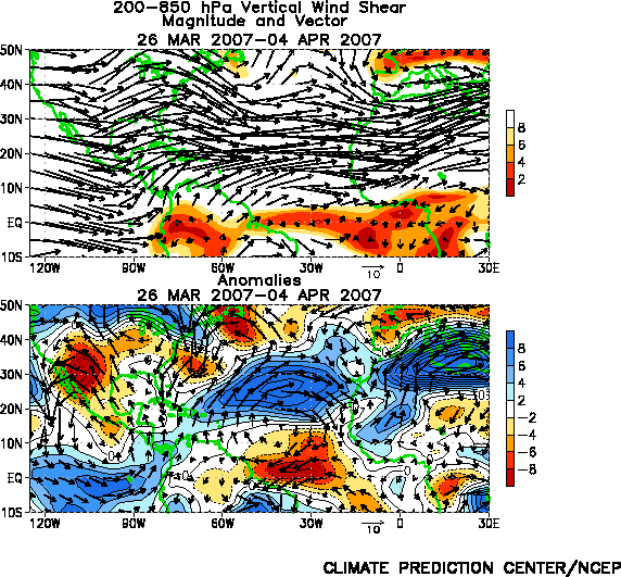
Mean (top) and anomalous (bottom) 200-850 hPa vertical wind shear magnitude (m s-1) and vector for the last 10 days. In top panel only total vertical shear values less than 8 ms-1 are shaded. In bottom panel the anomalous vertical shear magnitude (shaded) is calculated as the magnitude of the observed total shear vector minus the climatological mean (observed shear - climatological shear). A reference vector with amplitude of 10 ms-1 is shown below each panel. Anomalies are departures from the 1979-95 base period daily means.


NOAA/ National Weather Service
NOAA Center for Weather and Climate Prediction
Climate Prediction Center
5830 University Research Court
College Park, Maryland 20740
Page Author: Climate Prediction Center Internet Team
Page last modified: March 9, 2005
Disclaimer
Information Quality
Credits
Glossary
Privacy Policy
Freedom of Information Act (FOIA)
About Us
Career Opportunities