|
The 2014 Atlantic hurricane season outlook is an official product of the National Oceanic and Atmospheric Administration (NOAA) Climate Prediction Center (CPC). The
outlook is produced in collaboration with hurricane experts from the National Hurricane Center (NHC) and the Hurricane Research Division (HRD). The Atlantic hurricane
region includes the North Atlantic Ocean, Caribbean Sea, and Gulf of Mexico.
Interpretation of NOAA’s Atlantic hurricane season outlook
This outlook is a general guide to the expected overall activity during the upcoming hurricane season. It is not a seasonal hurricane landfall forecast, and it does not
predict levels of activity for any particular region.
Preparedness
Hurricane disasters can occur whether the season is active or relatively quiet. It only takes one hurricane (or tropical storm) to cause a disaster. Residents, businesses,
and government agencies of coastal and near-coastal regions are urged to prepare for every hurricane season regardless of this, or any other, seasonal outlook. NOAA, the
Federal Emergency Management Agency (FEMA), the National Hurricane Center (NHC), the Small Business Administration, and the American Red Cross all provide important
hurricane preparedness information on their web sites.
NOAA does not make seasonal hurricane landfall predictions
NOAA does not make seasonal hurricane landfall predictions. Hurricane landfalls are largely determined by the weather patterns in place as the hurricane approaches, which
are only predictable when the storm is within several days of making landfall.
Nature of this Outlook and the "likely" ranges of activity
This outlook is probabilistic, meaning the stated "likely" ranges of activity have a certain likelihood of occurring. The seasonal activity is expected to fall within
these ranges in 7 out of 10 seasons with similar climate conditions and uncertainties to those expected this year. They do not represent the total possible ranges of
activity seen in past similar years.
This outlook is based on 1) predictions of large-scale climate factors known to influence seasonal hurricane activity, and 2) climate models that directly predict
seasonal hurricane activity.
Sources of uncertainty in this seasonal outlook
1. Predicting El Niño and La Niña (also called the El Niño-Southern Oscillation, or ENSO) impacts is an ongoing scientific challenge facing climate scientists today. Such
forecasts made during the spring generally have limited skill.
2. Many combinations of named storms and hurricanes can occur for the same general set of climate conditions. For example, one cannot know with certainty whether a given
climate signal will be associated with several short-lived storms or fewer longer-lived storms with greater intensity.
3. Model predictions of sea-surface temperatures, vertical wind shear, moisture, and stability have limited skill this far in advance of the peak months (August-October)
of the hurricane season.
4. Weather patterns that are unpredictable on seasonal time scales can sometimes develop and last for weeks or months, possibly affecting seasonal hurricane activity.
2014 Atlantic Hurricane Season Outlook: Summary
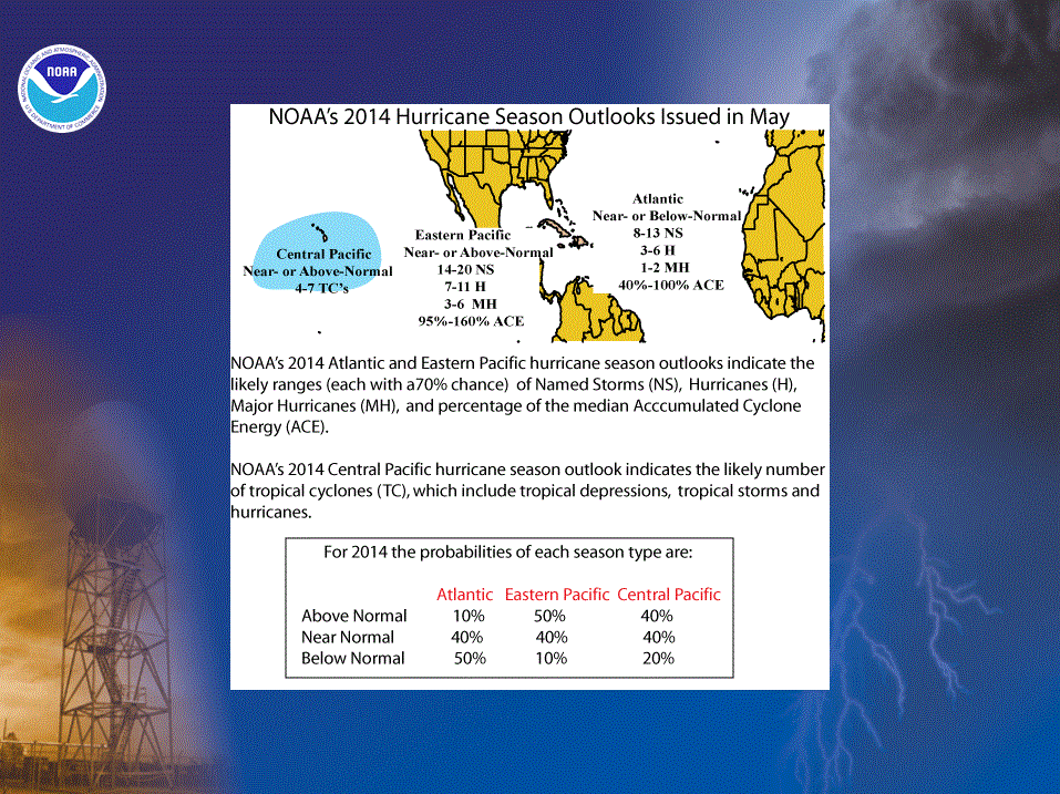
NOAA’s 2014 Atlantic Hurricane Season Outlook indicates that a near-normal or below-normal hurricane season is likely this year. The outlook calls for a 50%
chance of a below-normal season, a 40% chance of a near-normal season, and only a 10% chance of an above-normal season.
See NOAA definitions of above-, near-, and below-normal seasons. The Atlantic hurricane region
includes the North Atlantic Ocean, Caribbean Sea, and Gulf of Mexico.
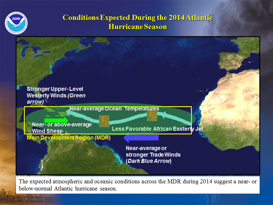
The predicted oceanic and atmospheric conditions across the MDR typify a near- or below-normal Atlantic hurricane season, and contrast with those
seen throughout the current high activity era for Atlantic hurricanes that began in 1995.
The expected conditions for 2014 reflect the likely development of El Niño during the summer or early fall, along with model predictions for
near-average or below-average sea-surface temperatures (SSTs) in the Atlantic hurricane Main Development Region (MDR) (which spans the Caribbean Sea and tropical
Atlantic Ocean between 9oN-21.5oN). Also, current atmospheric conditions are not showing the typical precursor signals of an above-normal season,
further reducing our expectation for an above normal hurricane season.
Based on the current and expected conditions, combined with model forecasts, we estimate a 70% probability for
each of the following ranges of activity during 2014:
- 8-13 Named Storms
- 3-6 Hurricanes
- 1-2 Major Hurricanes
- Accumulated Cyclone Energy (ACE) range of 40%-100% of the median.
The seasonal activity is expected to fall within these ranges in 70% of seasons with similar climate conditions and uncertainties to those expected this year. These
ranges do not represent the total possible ranges of activity seen in past similar years.
These expected ranges are centered below the official NHC 1981-2010 seasonal averages of 12 named storms, 6 hurricanes, and 3 major hurricanes.
Uncertainties
One uncertainty in this 2014 outlook lies in exactly when El Niño will develop and how strong it will become. Another uncertainty lies in how much the oceanic and
atmospheric conditions across the MDR will begin to take on characteristics of the current high activity era for Atlantic hurricanes, as they have in most seasons since
1995. Cooler Atlantic SSTs and a stronger El Niño could produce activity levels near the lower end of the predicted ranges, while warmer Atlantic SSTs and a weaker El Niño
could result in activity toward the higher end of the predicted ranges.
This Atlantic hurricane season outlook will be updated in early August, which coincides with the onset of the peak months of the hurricane season.
Hurricane Landfalls:
It only takes one storm hitting an area to cause a disaster, regardless of the overall activity predicted in the seasonal outlook. Therefore, residents, businesses, and
government agencies of coastal and near-coastal regions are urged to prepare every hurricane season regardless of this, or any other, seasonal outlook.
Predicting where and when hurricanes will strike is related to daily weather patterns, which are not reliably predictable weeks or months in advance. Therefore, it is
currently not possible to accurately predict the number or intensity of landfalling hurricanes at these extended ranges, or whether a particular locality will be impacted
by a hurricane this season.
DISCUSSION
1. Expected 2014 activity
Climate signals and evolving oceanic and atmospheric conditions, combined with model forecasts, indicate that a near-normal or below-normal Atlantic
hurricane season is likely in 2014. This outlook calls for a 50% chance of a below-normal season, a 40% chance of a near-normal season, and only a 10% chance of an above-normal
season. See NOAA definitions of above-, near-, and below-normal seasons.
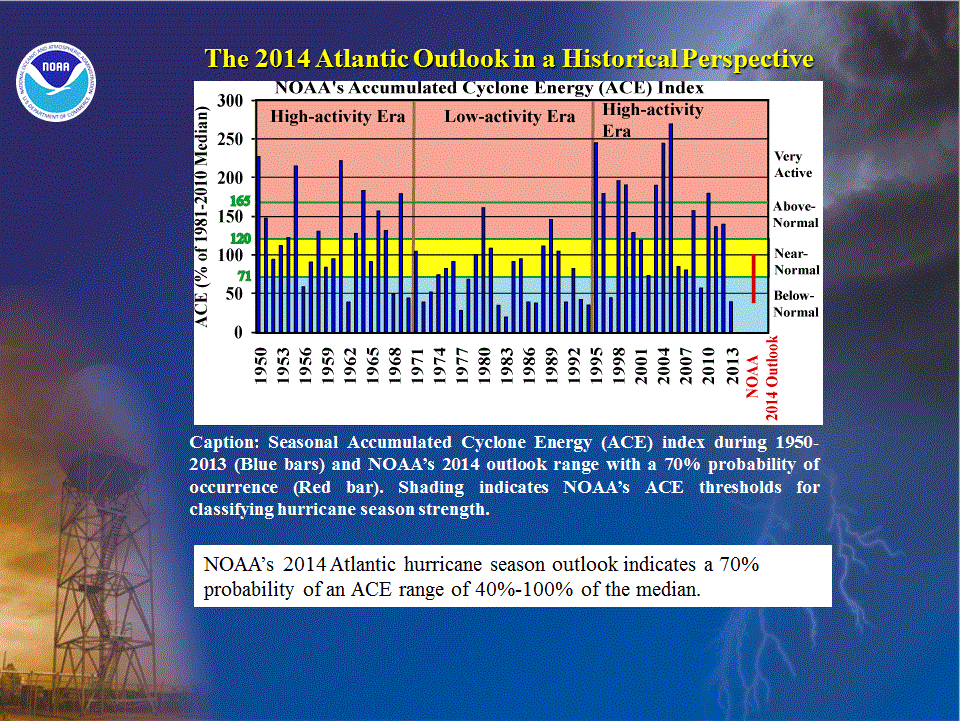
An important measure of the total overall seasonal activity is NOAA’s Accumulated Cyclone Energy (ACE) index, which accounts for the combined
intensity and duration of named storms and hurricanes during the season. This outlook indicates a 70% chance that the 2014 seasonal ACE range will be 40%-100% of the
median. According to NOAA’s hurricane season classifications, an ACE value below 71.4% of the 1981-2010
median reflects a below-normal season, and an ACE value of 71.4%-120% reflects a near-normal season.
The 2014 Atlantic hurricane season is predicted to produce (with 70% probability for each range) 8-13 named storms, of which 3-6 are expected to
become hurricanes, and 1-2 are expected to become major hurricanes. These ranges are centered below the 1981-2010 period averages of 12 named storms, 6 hurricanes and 3
major hurricanes.
For the U.S. and the region around the Caribbean Sea, the historical probability of multiple hurricane strike decreases with decreasing seasonal activity and El Niño.
Nonetheless, for each region, there are numerous instances in the historical record of hurricane strikes during below-normal seasons, and even more instances of hurricane
strikes during near-normal seasons. Also, the likelihood of at least one U.S. hurricane landfall is the same during El Niño as it is during La Niña and ENSO-Neutral.
Predicting the location, number, timing, and strength of hurricanes landfalls is ultimately related to the daily weather patterns, which are not predictable weeks or
months in advance. As a result, it is currently not possible to reliably predict the number or intensity of landfalling hurricanes at these extended ranges, or whether a
given locality will be impacted by a hurricane this season. Therefore, NOAA does not make an official seasonal hurricane landfall outlook.
2. Science behind the 2014 Outlook
The 2014 seasonal hurricane outlook reflects the likely development of El Niño during the summer or early fall, combined with an expectation
of near-average or below-average sea-surface temperatures in the Atlantic hurricane MDR. These non-conducive conditions are expected to be
partially offset by the ongoing warm phase of the Atlantic Multi-Decadal Oscillation (AMO) and associated tropical multi-decadal signal, which
have contributed strongly to the current high activity era for Atlantic hurricanes that began in 1995. Overall, the predicted oceanic and atmospheric
conditions for 2014 across the MDR typify a near- or below-normal Atlantic hurricane season.
The outlook takes into account dynamical model predictions from the NOAA Climate Forecast System (CFS), NOAA Geophysical Fluid Dynamics Lab (GFDL) model FLOR-FA, the
European Centre for Medium Range Weather Forecasting (ECMWF), the United Kingdom Meteorology (UKMET) office, the EUROpean Seasonal to Inter-annual Prediction (EUROSIP)
ensemble, along with ENSO (El Niño/ Southern Oscillation) forecasts from models contained in the suite of Niño 3.4 SST forecasts compiled by the
IRI (International Research Institute for Climate and Society) and the NOAA Climate Prediction Center.
a. El Niño
The main climate factor guiding the 2014 Atlantic hurricane season outlook is the likely development of El Niño during the summer or early fall. El Niño suppresses
Atlantic hurricane activity (Gray 1984) by producing a set of non-conducive conditions within the MDR, including 1) enhanced vertical wind shear, 2) stronger easterly
trade winds, 3) a configuration of the African easterly jet that is less conducive to hurricane development from easterly waves moving off the African coast, and 4)
increased sinking motion.
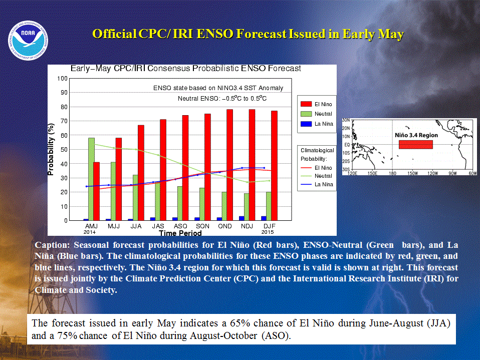
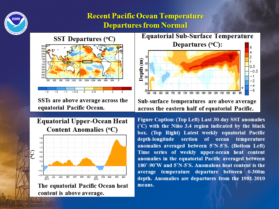
At present, equatorial Pacific SSTs are above average, with the largest departures (exceeding 1oC) centered on the date line. SST
anomalies in all of the Niño regions are also increasing, and anomalies in the Niño 3.4 region, which spans the central and east-central equatorial Pacific
between 120oW-170oW, are currently 0.4oC. This value is approaching the CPC’s lower threshold for El Niño (+0.5oC).
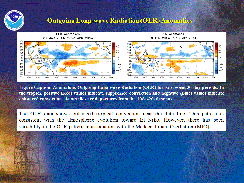
Observations show that the atmosphere is also trending to an El Niño state. For example, a time-longitude section of 200-hPa velocity potential anomalies shows
anomalous upper-level divergence since January over the central equatorial Pacific. This signal is opposite to that seen during
May-September 2013, and is consistent with enhanced convection near the date line, a key feature of El Niño.
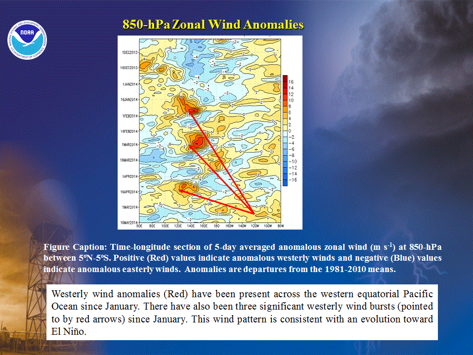
Anomalous westerly trade winds across the western equatorial Pacific, along with several westerly wind bursts, have also been present since
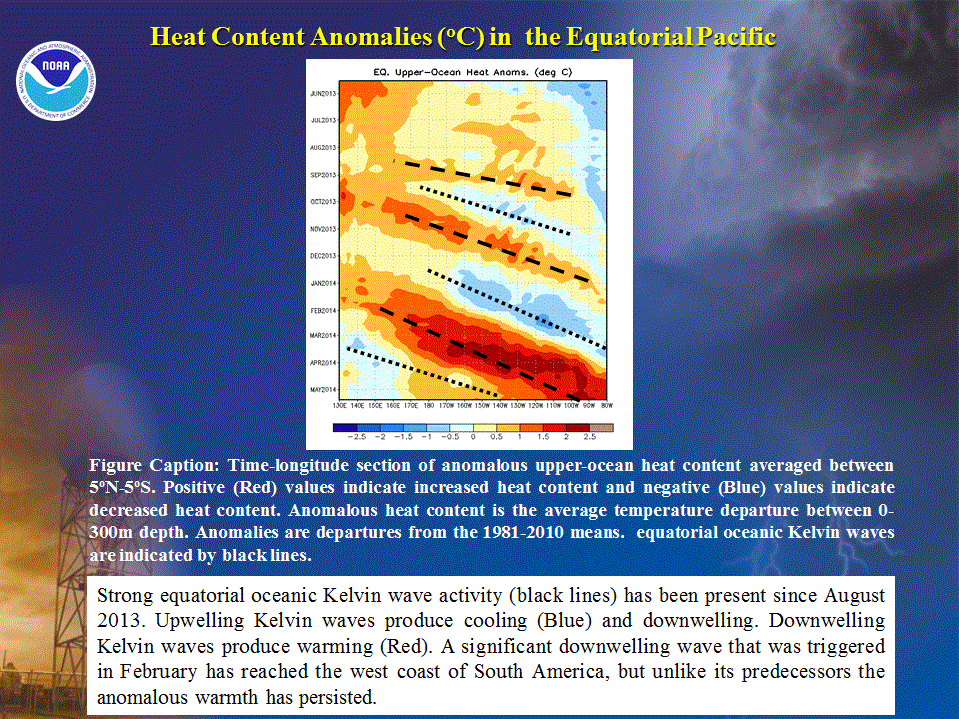
January. A westerly wind burst triggered a strong downwelling equatorial oceanic Kelvin wave in February, and this wave subsequently reached
the west coast of South America in late April. This Kelvin wave acted to shift the oceanic thermocline deeper into the ocean, resulting in above-average temperatures and
increased heat content between the thermocline and the ocean surface.
A depth-longitude section of sub-surface temperature anomalies and a time series of the upper-ocean heat content highlight the substantial sub-surface
warmth associated with this Kelvin wave. The persistence of the westerly wind anomalies has helped to lock in this anomalous warmth, further setting the stage
for El Niño.
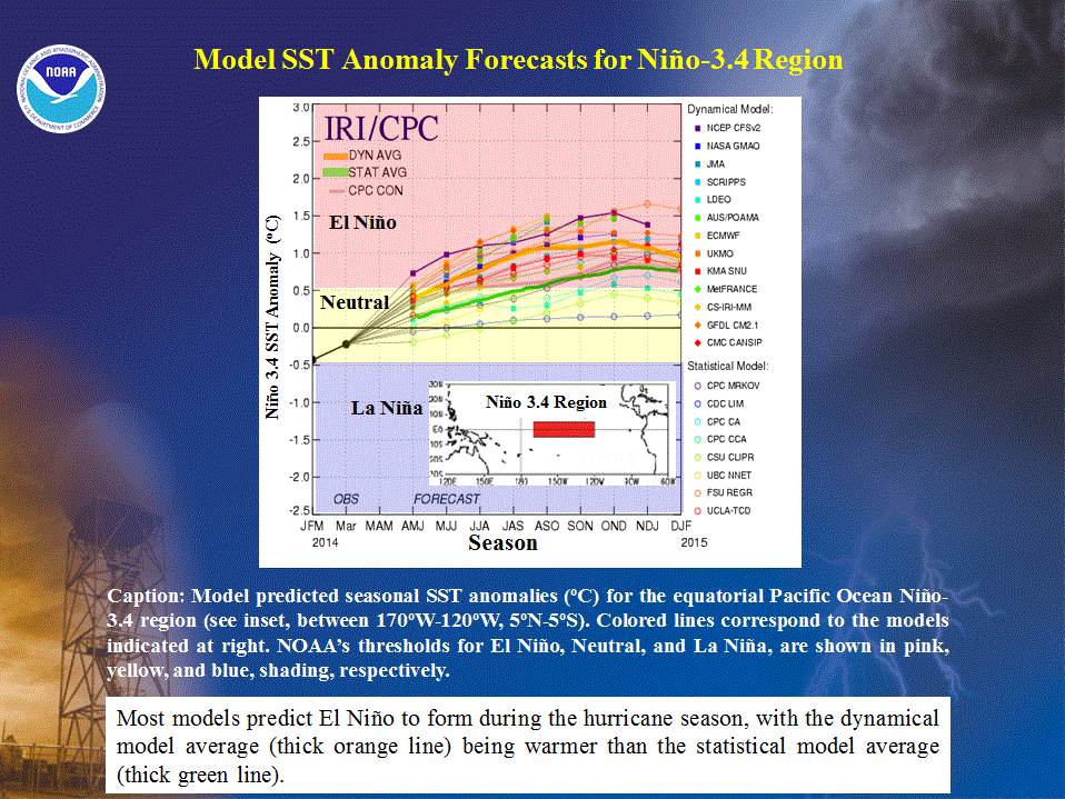
The average forecast of the dynamical models (closed markers) contained in the suite of IRI/ CPC Niño 3.4 SST forecasts (yellow line) predicts El
Niño to form during the May-July (MJJ) season and to reach moderate strength (SST values of 1oC -1.5,sup>oC) during ASO. The statistical model forecasts
(open markers) are generally cooler than the dynamical model predictions, and show a weak El Niño during the ASO season. These differing forecasts produce some uncertainty
as to exactly when El Niño will develop and how strong it will become.
b. Sea surface temperatures across the Main Development Region (MDR)
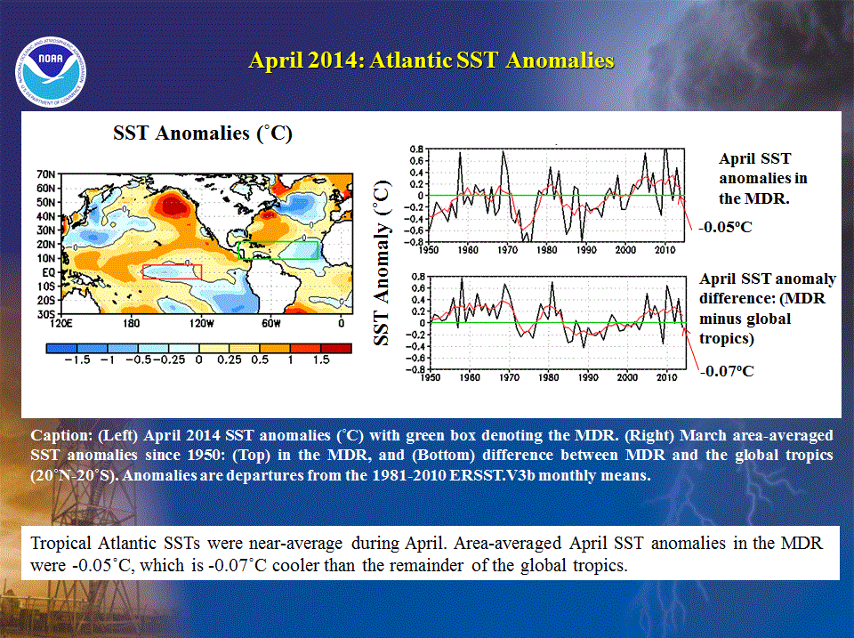
SSTs within the Atlantic hurricane MDR are currently below-average in the central/ eastern tropical Atlantic and slightly above-average in the
Caribbean Sea. SST departures averaged across the MDR are near zero, which is comparable to the average departure for the remainder of the global tropics. Neither of these
signals is a clear indicator for an above-normal Atlantic hurricane season.
One issue for this outlook is whether or not the SST anomalies in the MDR will warm as the season progresses, as they have during most seasons since 1995 in association
with the warm phase of the Atlantic Multi-decadal Oscillation (AMO). The typical warming mechanism is weaker tropical easterly trade winds
within the MDR, which reduces the amount of cold water being upwelled in the eastern MDR, the amount of cold water being transported into the MDR, and the amount of
evaporative cooling from the ocean surface. El Niño favors stronger easterly trade winds in the MDR, which suggests that additional anomalous warming might be limited or
absent.
Consistent with these interpretations, many dynamical models are predicting that SSTs in the MDR will remain near- or below-average throughout the hurricane season. The
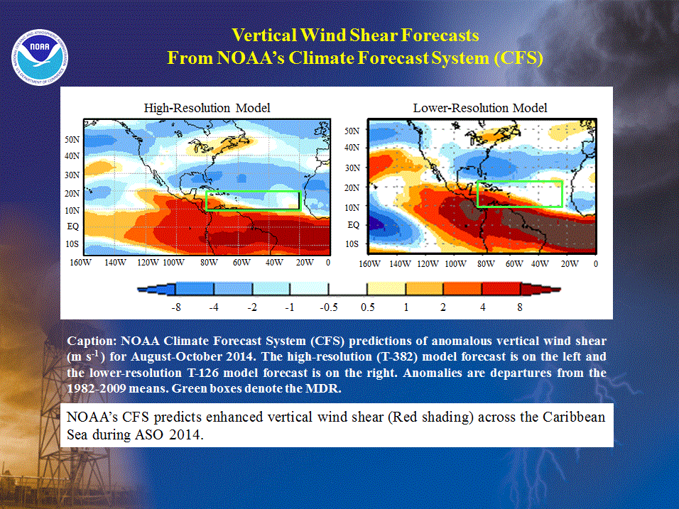
CFS high-resolution (T-382) and lower resolution (T-126) models are both predicting below-average SSTs across the Caribbean Sea during ASO.
However, these two models differ in their predicted intensity of El Niño, with the lower-resolution model predicting a strong El Niño. Cooler Atlantic SSTs and a stronger
El Niño could produce activity levels near the lower end of the predicted ranges, while warmer Atlantic SSTs and a weaker El Niño could result in activity toward the
higher end of the predicted ranges.
c. Atmospheric conditions across the Main Development Region (MDR)
The AMO is coupled with the atmospheric tropical multi-decadal signal (Goldenberg et al. 2001, Bell and Chelliah 2006). Within the MDR, key
atmospheric features of these climate signals have contributed to the current high-activity era in the Atlantic basin that began in 1995 (Bell et al. 2014). These features
include: 1) reduced vertical wind shear, 2) weaker easterly trade winds, 3) a configuration of the African easterly jet (i.e. increased cyclonic shear) that is much more
conducive to hurricane development from tropical cloud systems (aka easterly waves) moving off the African coast, 4) warm, moist, and unstable air, and 5) reduced sinking
motion.
As has been seen since 1995, reduced vertical wind shear within the MDR is typically present prior to the start of an above-normal season. However, the
vertical wind shear is currently stronger than average across much of the MDR. The
mid-and upper-atmospheric sinking motion is also currently stronger than average. The development of El Niño would mean a likely continuation of
these non-conducive conditions, and both versions of the CFS model are predicting enhanced vertical wind shear across the western MDR during
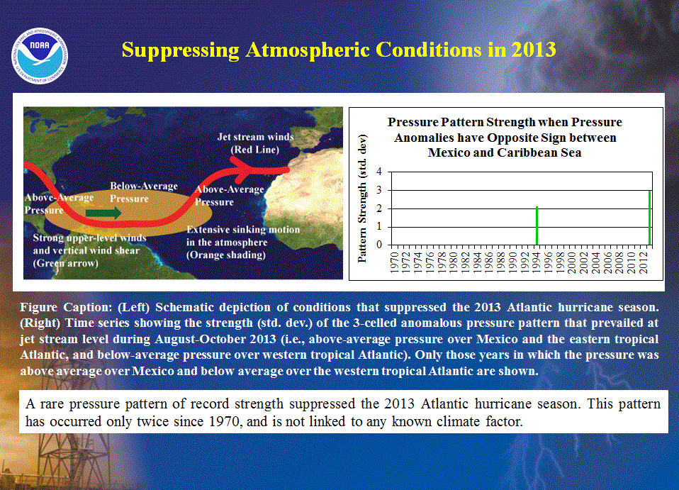
ASO 2014. Strong vertical wind shear and sinking motion, linked to a rare jet stream pattern of record strength, were key suppressing factors during
the 2013 Atlantic hurricane season (Bell et al. 2014).
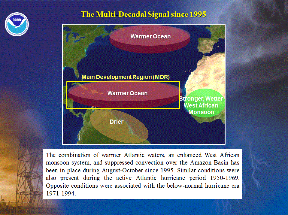
3. Multi-decadal fluctuations in Atlantic hurricane activity
Atlantic hurricane seasons exhibit extended periods lasting decades (25-40 years) of generally above-normal or below-normal activity. These
multi-decadal fluctuations in hurricane activity result almost entirely from differences in the number of hurricanes and major hurricanes forming from tropical storms that
first develop in the MDR.
The current high-activity era began in 1995 (Goldenberg et al. 2001). Hurricane seasons during 1995-2013 have averaged about 15 named storms, 8 hurricanes, and 4 major
hurricanes, with an ACE index of 151% of the median. NOAA classifies 12 of the 20 seasons since 1995 as above normal, with eight being very active (i.e., hyperactive
defined by ACE > 165% of median). Only three seasons since 1995 were below normal (1997, 2009, and 2013).
This high level of activity contrasts sharply to the low-activity era of 1971-1994 (Goldenberg et al. 2001), which averaged 8.5 named storms, 5 hurricanes, and 1.5 major
hurricanes, with an ACE index of only 74% of the median. One-half of the seasons during this period were below normal, only two were above normal (1980, 1989), and none
were hyperactive.
Within the MDR, the atmospheric circulation anomalies that contribute to these long-period fluctuations in hurricane activity are strongly linked to the
Tropics-wide multi-decadal signal (Bell and Chelliah 2006), which incorporates the warm phase of the AMO and an enhanced west African monsoon system. A change
in the phase of the tropical multi-decadal signal coincides with the transition in 1995 from a low-activity era to the current high-activity era.
4. Uncertainties in the Outlook
The 2014 Atlantic hurricane season will likely be near- or below- normal. Key indications for this outlook are 1) the expected development of El Niño, 2) expected near- or
below-average SSTs in the MDR during ASO, and 3) no strong indication from current atmospheric conditions within the MDR (i.e. vertical wind shear, vertical motion) that
the season will be above normal.
Uncertainties in the outlook are related to the timing and strength of El Niño, and to a limited confidence in model forecasts for Atlantic SST anomalies. Therefore, there
is uncertainty in the extent to which these factors will suppress the warm phase of the AMO and tropical multi-decadal signal.
NOAA FORECASTERS
Climate Prediction Center
Dr. Gerry Bell, Lead Forecaster, Meteorologist; Gerry.Bell@noaa.gov
Dr. Jae Schemm, Meteorologist; Jae.Schemm@noaa.gov
National Hurricane Center
Eric Blake, Hurricane Specialist; Eric.S.Blake@noaa.gov
Todd Kimberlain, Hurricane Specialist; Todd Kimberlain@noaa.gov
Dr. Chris Landsea, Meteorologist; Chris.Landsea@noaa.gov
Dr. Richard Pasch, Hurricane Specialist; Richard.J.Pasch@noaa.gov
Hurricane Research Division
Stanley Goldenberg, Meteorologist; Stanley.Goldenberg@noaa.gov
REFERENCES
Bell, G. D., and co-authors, 2014: [The Tropics] The 2013 North Atlantic Hurricane Season: A Climate Perspective [in “State of the Climate in 2013”]. Bull. Amer. Meteor. Soc., 95 (8), In press.
Bell, G. D., and M. Chelliah, 2006: Leading tropical modes associated with interannual and multi-decadal fluctuations in North Atlantic hurricane activity. J. of Climate. 19, 590-612.
Goldenberg, S. B., C. W. Landsea, A. M. Mestas-Nuñez, and W. M. Gray, 2001: The recent increase in Atlantic hurricane activity: Causes and implications. Science, 293, 474-479.
Gray, W. M., 1984: Atlantic seasonal hurricane frequency: Part I: El Niño and 30-mb quasi-bienniel oscillation influences. Mon. Wea. Rev., 112, 1649-1668.
|


