Skip Navigation Links www.nws.noaa.gov 
NOAA logo - Click to go to the NOAA home page National Weather Service   NWS logo - Click to go to the NWS home page
Climate Prediction Center


HOME > Monitoring and Data > Climate & Weather Linkage > Teleconnections > Pacific/North American Pattern


  • Current Conditions

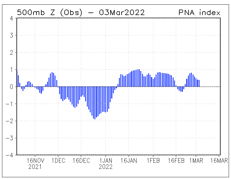
The daily PNA index is constructed by projecting the daily (00Z) 500mb height anomalies over the Northern Hemsiphere onto the loading pattern of the PNA.  Please note that all year-round monthly mean anomaly data has been used to obtain the loading pattern of the PNA (Methodology).  Since the PNA has the largest variability during the cold season, the loading pattern primarily captures characteristics of the cold season PNA pattern.

The daily PNA index and its forecasts using MRF and Ensemble mean forecast data are shown for the previous 120 days as indicated and they are normalized by standard deviation of the monthly PNA index from 1950 to 2000. A 3-day running mean is applied for the forecast indices.

 
  • Observations
Observed Daily Pacific North American Oscillation Index.
 
  • Monthly mean PNA index since January 1950
  • Animations (circulations)

[Back to the Top]

 
  • Forecasts

[Back to the Top]

 
  • Expert Discussions

[Back to the Top]

 
  • Composites

[Back to the Top]

 
  • Linkage to Weather

[Back to the Top]

 
  • FAQ's

[Back to the Top]

 
  • Publications

[Back to the Top]


NOAA/ National Weather Service
National Centers for Environmental Prediction
Climate Prediction Center
5830 University Research Court
College Park, Maryland 20740
Page Author: Climate Prediction Center Internet Team
Page last modified: December 12, 2005
Disclaimer
Information Quality
Credits
Glossary
Privacy Policy
Freedom of Information Act (FOIA)
About Us
Career Opportunities