contributed by Stephen Zebiak and Mark Cane
Lamont-Doherty Earth Observatory, Columbia Univ., Palisades,
New York
Since the middle to late 1980s, forecasts of the Niño 3 SST
anomaly have been regularly made at Lamont-Doherty Earth Observatory of
Columbia University using a simple coupled ocean-atmosphere dynamical model
(Cane et al. 1986, Cane and Zebiak 1987, Zebiak and Cane 1987). This represented
the beginning of a strong movement toward physical approaches to the diagnosis
and prediction of climate and its short-term fluctuations. Here we present
a few details of this model's current forecasts of Niño 3 and the
tropical Pacific basin. Forecasts using a new version of the model with
improved initialization are now additionally available; these will be highlighted
following a discussion of the forecasts of the standard version of the
model.
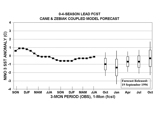
Figure 1 shows forecasts of the SST anomaly in Niño 3 for
3 to 15 months lead using data through July 1996, and the observed Niño
3 SST over the past 2 years. These forecasts are actually ensemble means
of forecasts from six consecutive months ranging from February to July
1996. Forecasts are adjusted to have the same mean and standard deviation
as the observed data for each calendar month and lead time. The vertical
bars show the error standard deviations. These do not necessarily become
larger with increasing lead time, because even with an unchanging expected
fraction of SST variance explained by the forecasts, the natural interannual
SST variability changes with season. (The vertical axis is in anomalous
C as opposed to standardized anomaly in which case the size of the error
bars would reflect only the skill of the forecasts.) In this case the forecasts
describe a continuation of below normal Nino 3 conditions through winter
1996-97, with some return toward normal following that winter.
A closer look at the forecast integrations is provided in Fig. 2,
where six individual SST forecasts beginning from 1-month-apart initial
conditions from February to July 1996 are shown along with the ensemble
mean which is used in Fig. 1. The forecasts shown in Fig. 2 may not correspond
exactly to those shown in Fig. 1, because in Fig. 2 the forecasts are adjusted
to have the same mean and standard deviation as observed data only on an
overall basis rather than for each calendar month and lead time. The spread
among the individual ensemble members is small to moderate from the initialization
times through spring 1997, becoming larger from mid-1997 onward.
Figure 3 shows 6, 9 and 12 month lead SST anomaly forecasts for the
tropical Pacific Basin, verifying in January, April and July of 1997, respectively.
These forecasts are adjusted to have the same mean and standard deviation
as observed data on an overall basis, so they are comparable with those
shown in Fig. 2 but not necessarily Fig. 1. Like those for other target
periods or for just Niño 3, the forecasts are adjusted for systematic
biases, such as an underestimation of amplitude of anomalies in the central
(but not eastern) Pacific, which would cause anomaly maxima to be placed
too far east or prevent the central Pacific from fully participating. A
statistical correction using singular value decomposition (SVD) is carried
out to do the adjustment. The 6, 9 and 12 month lead forecast shown in
Fig. 3 indicate a continuation of cool conditions through summer 1997,
but with a gradual decrease in intensity.
Recent research at Lamont has shown that the skill of the SST forecasts
can be increased significantly by improving the intialization system (Chen
et al. 1995). The existing system has used wind stress anomalies (derived
at Florida State University) to initialize the forecast runs, without current
analyzed SST data. A newly developed system allows observed SST data to
participate in the intialization process. Skill is found to increase not
only in the early part of a forecast run but at intermediate and long leads
as well. The "spring barrier" in skill that is present in the
original initialization scheme is substantially reduced using the improved
system.
When the new initialization system is applied to the current SST
forecast, the result is as shown in Fig. 4. The improved scheme produces
a forecast generally similar to the customary Lamont forecast, although
the negative anomalies continue through summer 1997 without abatement.
The individual initial condition trajectories for the new scheme (Fig.
5) show relatively less warming in 1997, and much lower spread, than for
the original scheme.
Cane, M., S.E. Zebiak and S.C. Dolan, 1986: Experimental forecasts of El Nino. Nature, 321, 827-832.
Cane, M. and S.E. Zebiak, 1987: Prediction of El Nino events using a physical model. In Atmospheric and Oceanic Variability, H. Cattle, Ed., Royal Meteorological Society Press, 153-182.
Chen, D., S.E. Zebiak, A.J. Busalacchi and M.A. Cane, 1995: An improved procedure for El Nino forecast-ing: Implications for predictability. Science, 269, 1699-1702.
Zebiak, S.E. and M.A. Cane, 1987: A model El Nino-Southern Oscillation. Mon. Wea. Rev., 115, 2262- 2278.
Fig. 1. Forecasts for the SST anomaly (oC) in
the Niño 3 region (5oN-5oS, 90o-150oW),
based on the simple coupled model of Cane and Zebiak. Filled squares at
the midpoints of the vertical forecast boxes represent the predictions,
and the vertical boxes (lines) show the one (two) error standard deviations.
The solid line represents the observed three month mean SST anomaly in
Niño 3 up to the most recently available data. The bars show forecasts
for 1 month mean SST anomalies at leads of 3, 6, 9, 12 and 15 months. See
text for additional detail.
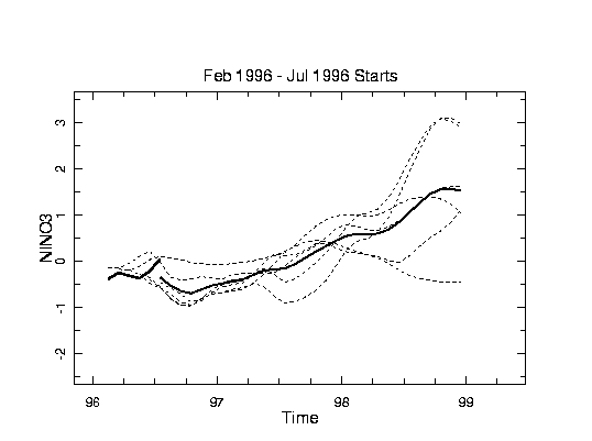
Fig. 2. Time series of forecasts of Niño 3 SST from the Cane and Zebiak coupled model, for individual 1-month-apart initial conditions from February to July 1996 (dashed lines) and the ensemble mean (solid line) used to form Fig. 1. However, an overall adjustment for the mean and standard deviation is used rather than lead- and season-specific adjustments as was done for Fig. 1. The thick solid line on left side shows the observed one month mean SST over the temporal range of the initial conditions.
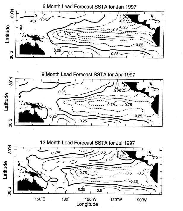
Fig. 3. Cane and Zebiak coupled model SST anomaly forecast fields for January, April and July 1997, made at 6, 9 and 12 month lead times, respectively. The forecasts are ensemble averages of 6 forecasts with 1-month-apart initial conditions ranging from February to July 1996. Adjustments for the mean and standard deviation are applied, based on lead time but independent of start time.
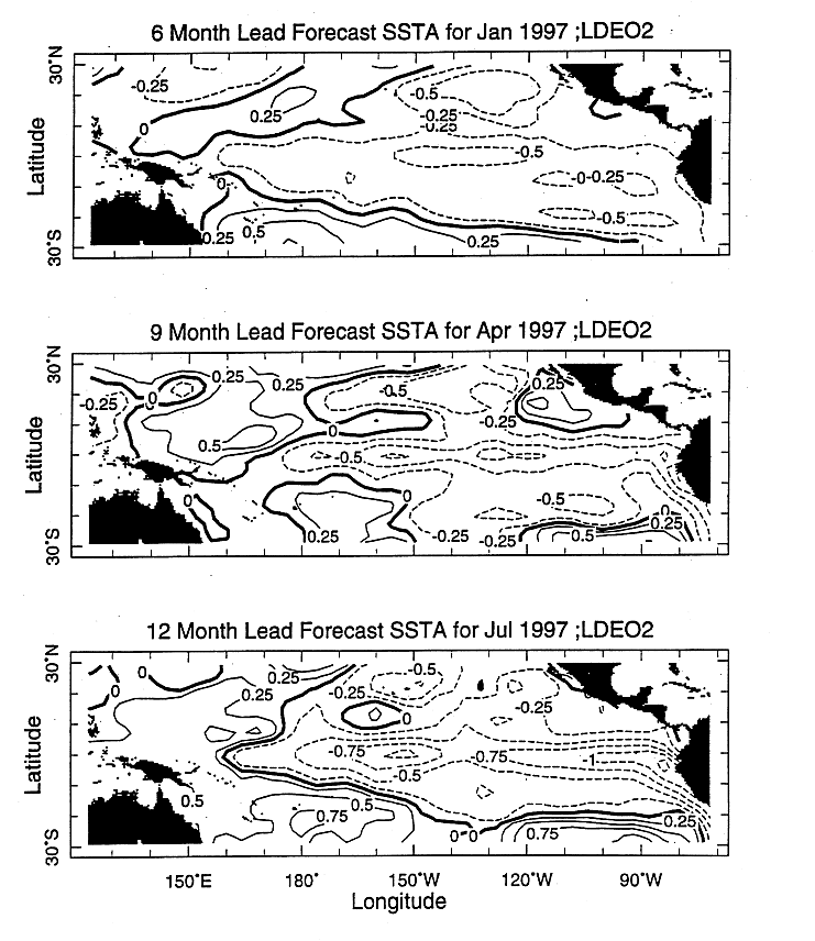
Fig. 4. As in Fig. 3 except for the forecast made using the new initialization procedure (LDEO2) (Chen et al. 1995).
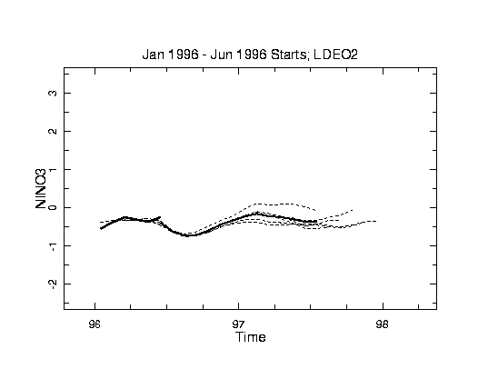
Fig. 5. As in Fig. 2 except for the forecast made using the new initialization
procedure (LDEO2) (Chen et al. 1995).