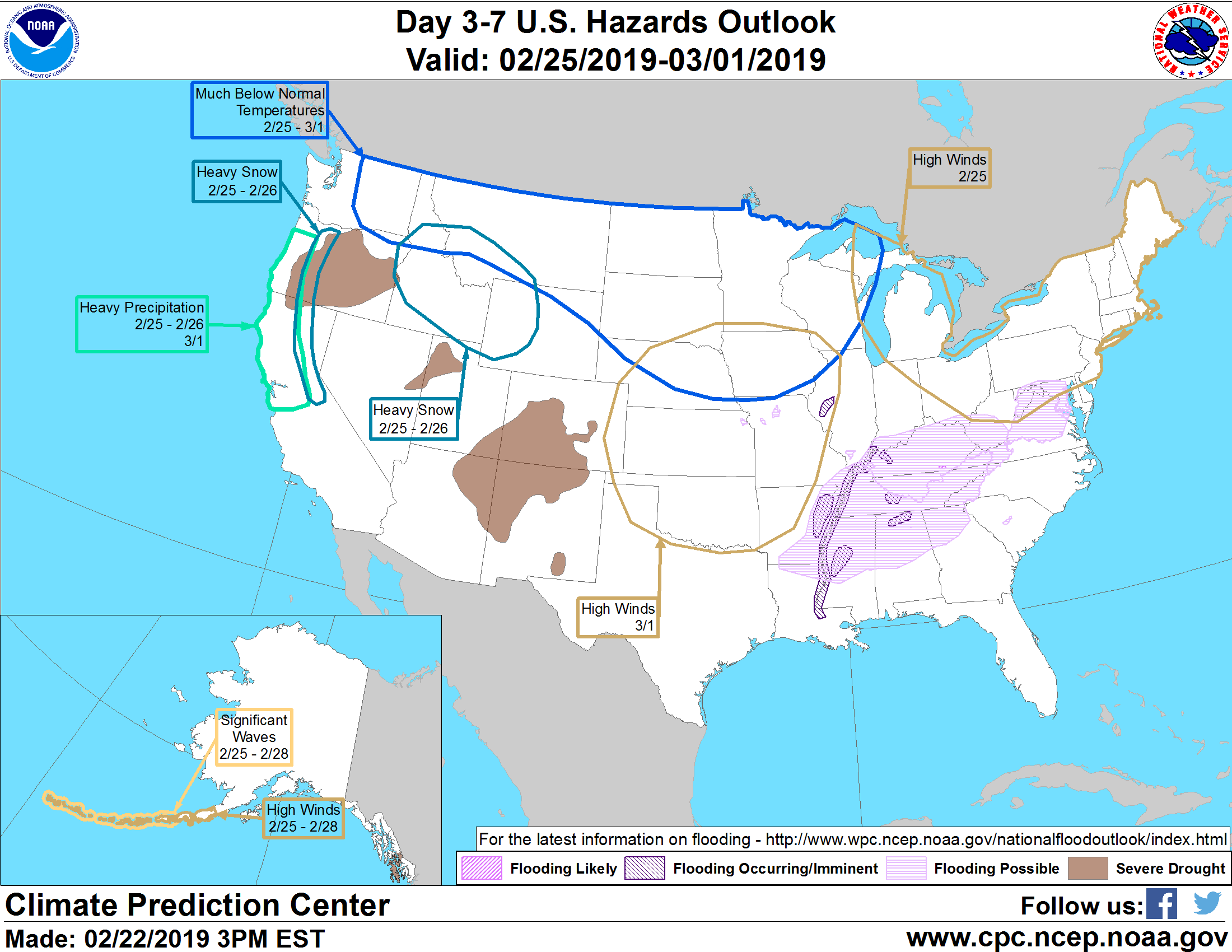
Valid Thursday, February 28, 2019 to Monday, March 11, 2019
Summary of Forecasts and Hazards
US Hazards Outlook
NWS Climate Prediction Center College Park MD
300 PM
EDT July 04 2025
Synopsis: From July 12 to 14, a strong mid-level
ridge of high pressure results in an elevated risk for extreme heat across the
West. Beginning on July 14, there is an increasing chance for extreme heat to
affect the Northern Great Plains as the western heat shifts eastward with time.
Following a lull in the Monsoon, an increasingly favorable pattern for locally
heavy rainfall across the Desert Southwest is expected during mid-July.
Hazards - Slight risk of extreme heat for the interior
Pacific Northwest and Northern Intermountain West, Sat, Jul 12.
- Slight risk of extreme heat for the Central Valley of California, Great
Basin, and parts of the Desert Southwest, Sat-Mon, Jul 12-14.
- Slight risk of extreme heat for the Northern Great Plains and Western Corn
Belt, Mon-Fri, Jul 14-18.
- Slight risk of heavy precipitation for southeastern Arizona and
southwestern New Mexico, Sat-Fri, Jul 12-18.
- Slight risk of heavy precipitation for the Desert Southwest, Wed-Fri, Jul
16-18.
Detailed SummaryFor Monday July 07 - Friday
July 11:
WPC Days 3-7 U.S.
Hazards For Saturday July 12 - Friday
July 18: The GEFS and ECENS are in good agreement that a 500-hPa ridge
peaks in strength prior to the start of the outlook period on July 12.
However, this anomalous ridge with 500-hPa height anomalies of +30 to +60
meters continues to favor at least a slight risk of extreme heat for parts of
the inland West through July 14. A slight risk of extreme heat is posted for
the interior Pacific Northwest on July 12, but a shortwave trough is expected
to progress inland and provide slight cooling after that date. For the Great
Basin, Central Valley of California, and parts of the Desert Southwest, a
slight risk of extreme heat is posted from July 12 to 14. The spatial extent is
based on where the GEFS and ECENS Probabilistic Extremes Tool (PETs) have a 20
to 40 percent chance of maximum temperatures exceeding the 85th percentile and
reaching extreme heat thresholds. A moderate risk was considered for the Salt
Lake City area, but the PETs have less than a 40 percent chance that maximum
temperatures reach 100 degrees F. The anomalous warmth during mid-July would
lead to the additional drying of fuels and elevate the wildfire danger across
the interior Pacific Northwest and northern Intermountain West.
The ensemble mean solutions are consistent that 500-hPa heights increase
with a warming trend across the northern Great Plains and Western Corn Belt
later in week-2. Based on the evolving longwave pattern, tendency for anomalous
heat to typically shift eastward from the West, and the calibrated heat index
(HI) tool having more a 20 percent chance of HI values to exceed 100 degrees F,
a slight risk of extreme heat is posted for the Northern Great Plains and
Western Corn Belt beginning on July 14.
As of 5am PDT on July 4, the National Hurricane Center is monitoring a
tropical wave a few hundred miles south of Mexico and states that there is a 80
percent chance of tropical cyclone (TC) development in the East Pacific during
the next week. Following this potential TC, many of the GEFS and ECENS ensemble
members favor additional TC genesis in the East Pacific during mid-July. The
continued active East Pacific with a model consensus for northwest tracks may
lead to enhanced low to mid-level moisture spreading northward from the Gulf of
California into the Desert Southwest. Unlike previous days, the model guidance
is in better agreement depicting the 500-hPa ridge axis shifting north over the
Four Corners region later in week-2. Given these favorable signs along with
support from the ECENS PET, the slight risk of heavy precipitation was expanded
to include more of the Desert Southwest, beginning on July 16. If good model
continuity is maintained, a flash flooding hazard may be added in subsequent
outlooks.
An amplified 500-hPa trough is forecast to become established over Alaska
during the second week of July. This anomalous trough favors much cooler
temperatures and above-normal precipitation across most of Alaska. Unseasonably
cold temperatures and even snow may affect the Brooks Range and North Slope
during mid-July.
Forecaster: Brad Pugh
$$
Click here to see a display of the GFS Ensemble Forecasts
Please consult local NWS Forecast Offices for short range forecasts and region-specific information.