|
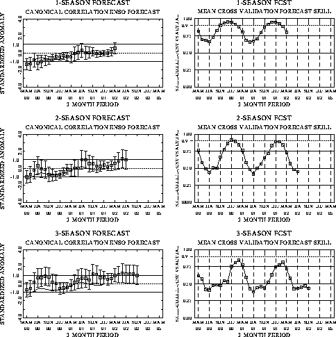
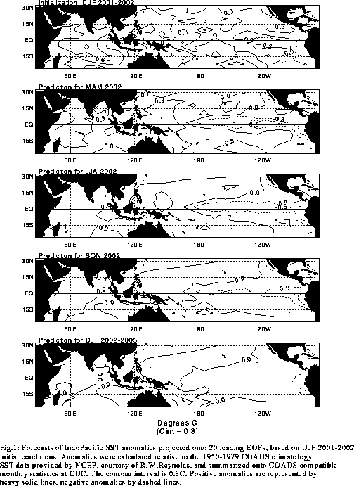
The canonical correlation analysis (CCA) forecast
of SST in the central Pacific (Barnett et al. 1988, Science, 241, 192-196;
Barnston and Ropelewski 1992, J. Climate, 5, 1316-1345), is shown in Figs.
F1 and F2. This forecast is produced
routinely by the Prediction Branch of the Climate Prediction Center. The predictions from
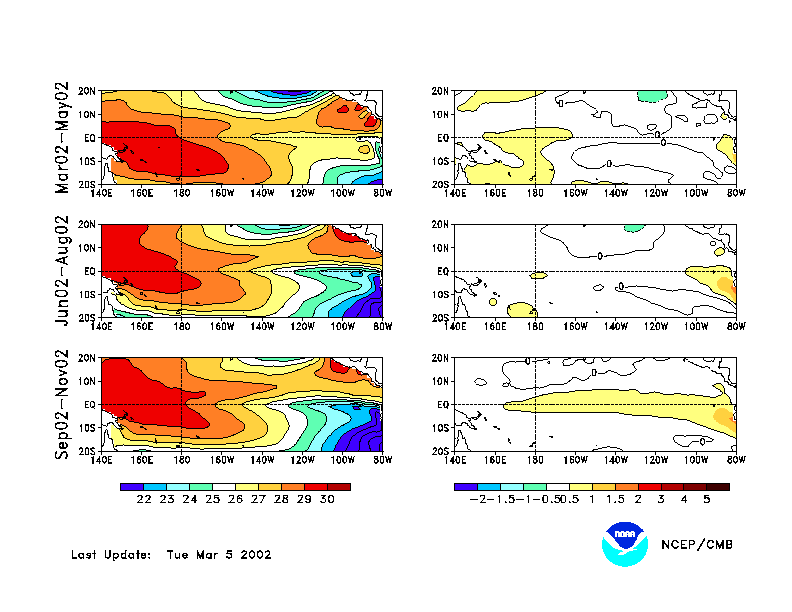
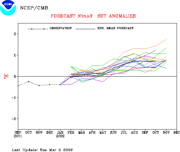
the National Centers for Environmental Prediction (NCEP) coupled ocean/atmosphere model
(Ji et al. 1998, Mon. Wea. Rev, 126, 1022-1034) are presented in Figs. F3 and F4a, F4b.
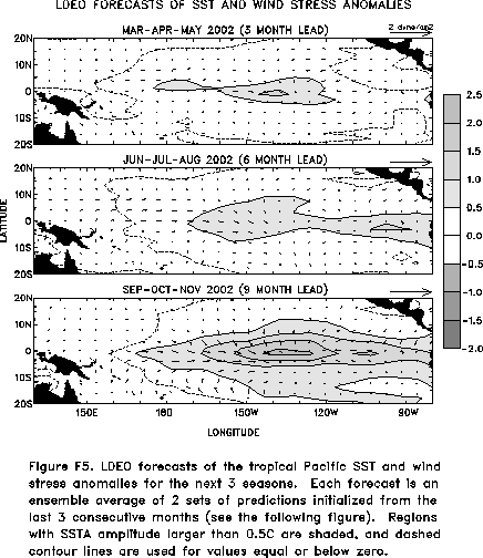
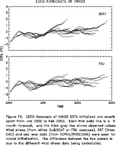
Predictions from the latest version of the LDEO model (Chen, D., M. A. Cane, S. E. Zebiak,
Rafael Canizares and A. Kaplan, 2000, Geophys. Res. Let., accepted) are shown in Figs.
F5 and F6. Predictions using linear
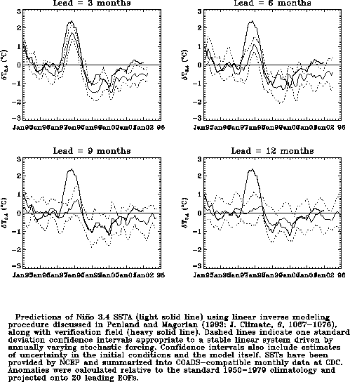
inverse modeling (Penland and Magorian 1993, J. Climate, 6, 1067-1076) are
shown in Figs. F7 and F8.
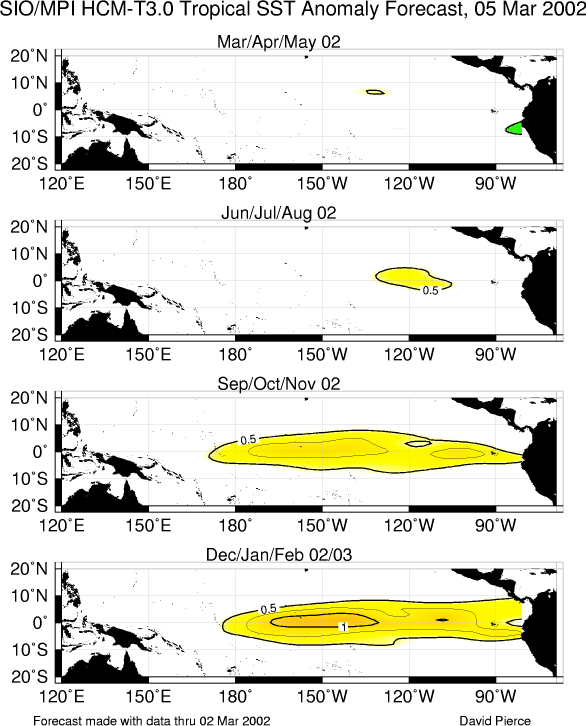
Predictions from the Scripps / Max Planck Institute (MPI) hybrid coupled model (Barnett et
al. 1993, J. Climate, 6, 1545-1566) are shown in Fig. F9.
Predictions from the ENSO-CLIPER statistical model (Knaff, J. A. and C. W. Landsea
1997, Wea. Forecasting, 12, 633-652) are shown in Fig. F10.
The CPC and the contributors to the Forecast
Forum caution potential users of this predictive information that they can expect only
modest skill.
Outlook
Based on the observed oceanic and atmospheric circulation patterns and their recent
evolution, the SST predictions, and the time of year, it seems likely that warm-episode
(El Niño) conditions will develop in the tropical Pacific during
the next 3 months and persist during the remainder of 2002.
Discussion
The evolution towards warm-episode conditions in the tropical Pacific continued during
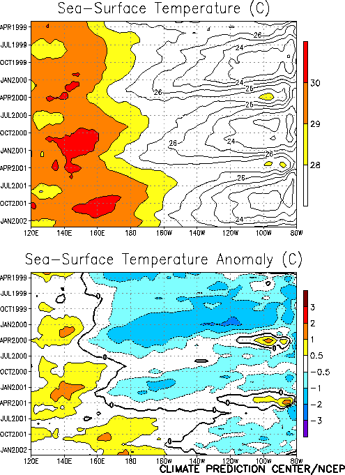
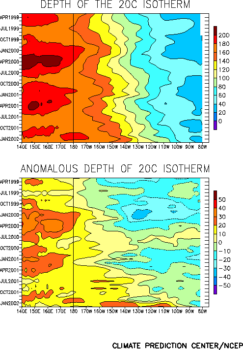
February 2002. Warmer-than-normal sea surface (Fig. T9) and
subsurface (Fig. T15) temperatures developed across the
equatorial Pacific during the month. By late in the month equatorial SST anomalies
exceeded +1°C in the vicinity of the date line (Fig. T18) and in the extreme eastern equatorial Pacific near
the South American coast. The warming of surface and subsurface waters along the South
American coast was due to the arrival of an oceanic Kelvin wave that has been propagating
eastward from the central equatorial Pacific since mid-December. The Kelvin wave
contributed to a substantial deepening of the oceanic thermocline from the dateline
eastward to the South American coast during January and February 2002 (Fig. T15). These conditions are often observed in the early
stages of El Niño.
Atmospheric indices are giving mixed signals concerning the evolution toward
warm-episode (El Niño/ Southern Oscillation - ENSO) conditions (Table T1). Those indices not yet supporting a developing El
Niño include the Southern Oscillation Index (Tahiti-Darwin
SOI), the low-level easterlies over the central equatorial Pacific, and the
upper-tropospheric (200-hPa) winds. In contrast, enhanced rainfall has been observed over
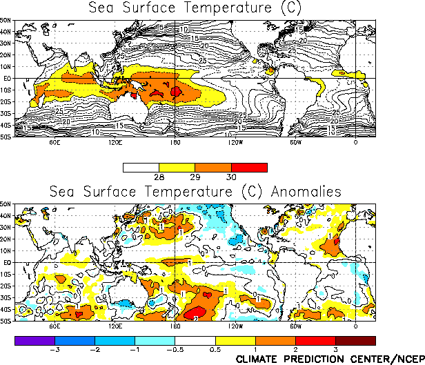
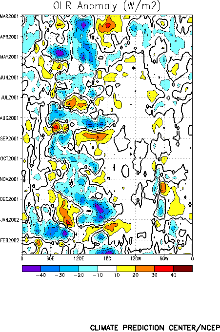
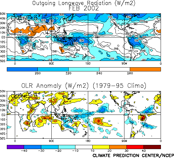
the tropical west-central Pacific, from Papua New Guinea eastward to the date line (180°W) since the beginning of 2002 (Figs. T11, T25), and in late February
enhanced rainfall also developed over the warmer-than-normal waters between the west coast
of South America and the Galapagos Islands. These features reflect the warming in the sea
surface temperatures, and are possibly the first atmospheric effects of a developing El Niño.
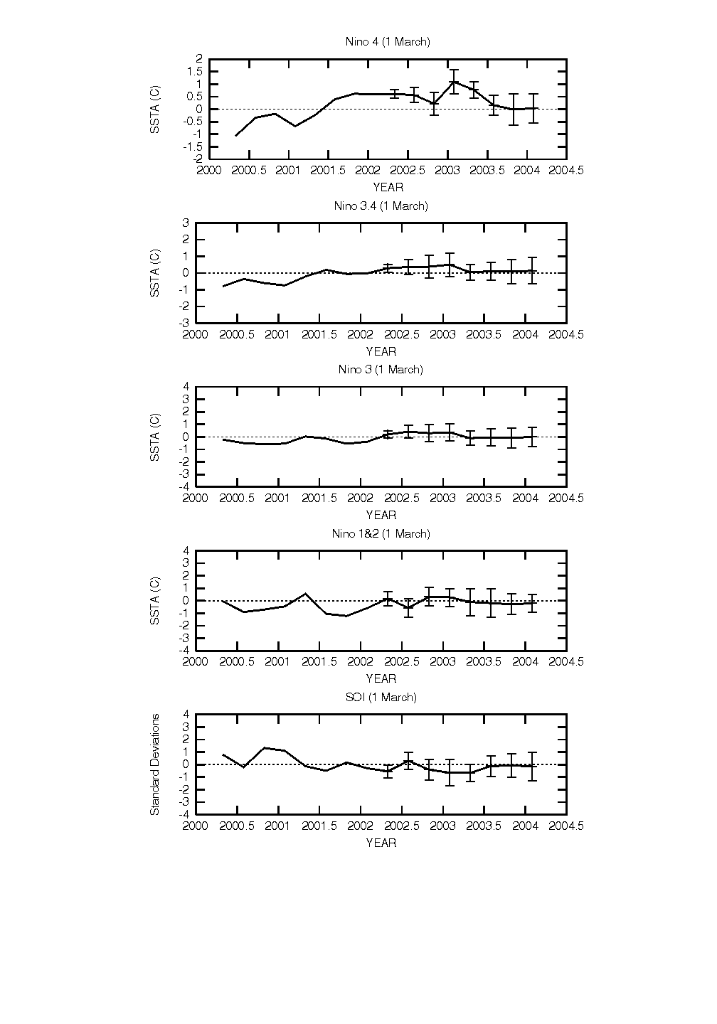
The latest statistical and coupled model predictions (Figs. F1,
F2, F3, F4, F5, F6, F7, F8, F9, F10)
show a spread from slightly cooler-than-normal conditions to moderate warm-episode
conditions during the remainder of 2002. The coupled models and some statistical
techniques that incorporate subsurface oceanic conditions indicate a slow evolution to
weak or moderate warm-episode (El Niño) conditions during the next several months. Other
techniques indicate that conditions will remain near normal or even return to slightly
colder than normal for the remainder of 2002. The recent evolution in oceanic conditions
supports the forecasts of a continued evolution toward El Niño.
Weekly updates of SST, 850-hPa wind, OLR, and
the equatorial subsurface temperature structure are available on the Climate Prediction
Center homepage at: http://www.cpc.ncep.noaa.gov (Weekly Update).
|


