|
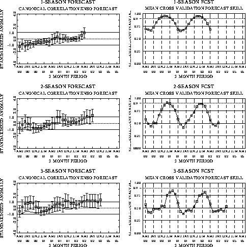
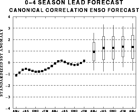
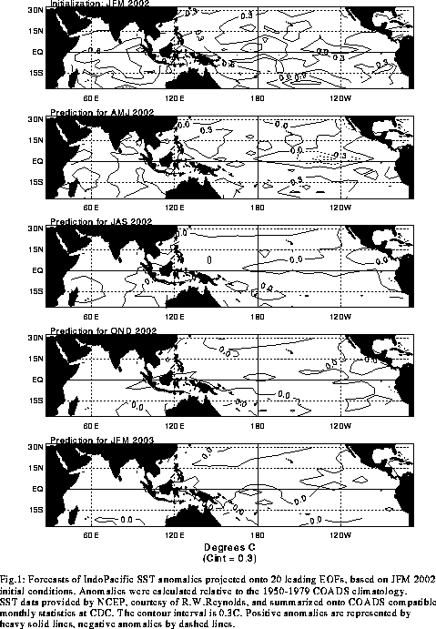
The canonical correlation analysis (CCA) forecast
of SST in the central Pacific (Barnett et al. 1988, Science, 241, 192-196;
Barnston and Ropelewski 1992, J. Climate, 5, 1316-1345), is shown in Figs.
F1 and F2. This forecast is produced
routinely by the Prediction Branch of the Climate Prediction Center. The predictions from
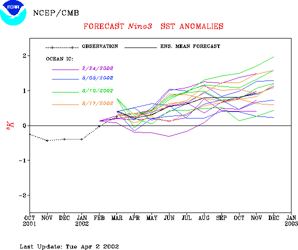
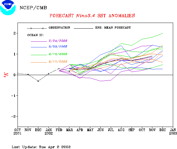
the National Centers for Environmental Prediction (NCEP) coupled ocean/atmosphere model
(Ji et al. 1998, Mon. Wea. Rev, 126, 1022-1034) are presented in Figs. F3 and F4a, F4b.
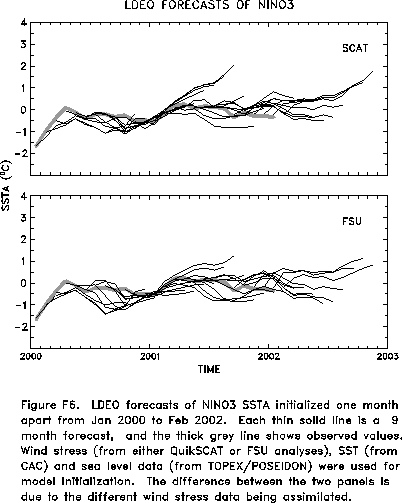
Predictions from the latest version of the LDEO model (Chen, D., M. A. Cane, S. E. Zebiak,
Rafael Canizares and A. Kaplan, 2000, Geophys. Res. Let., accepted) are shown in Figs.
F5 and F6. Predictions using linear
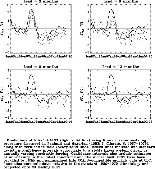
inverse modeling (Penland and Magorian 1993, J. Climate, 6, 1067-1076) are
shown in Figs. F7 and F8.
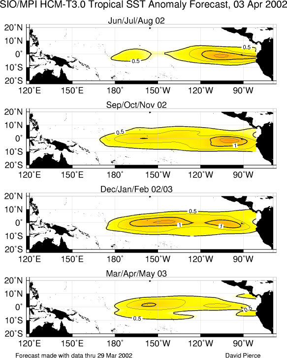
Predictions from the Scripps / Max Planck Institute (MPI) hybrid coupled model (Barnett et
al. 1993, J. Climate, 6, 1545-1566) are shown in Fig. F9.
Predictions from the ENSO-CLIPER statistical model (Knaff, J. A. and C. W. Landsea
1997, Wea. Forecasting, 12, 633-652) are shown in Fig. F10.
The CPC and the contributors to the Forecast
Forum caution potential users of this predictive information that they can expect only
modest skill.
Outlook
Based on the recent evolution of the observed oceanic surface and subsurface
temperature patterns, the SST predictions, and the time of year, it seems likely that
warm-episode (El Niño) conditions will continue to develop in the tropical Pacific during
the next 3 months and persist during the remainder of 2002.
Discussion
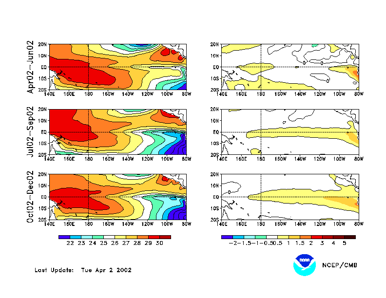
The evolution towards a warm (El Niño)
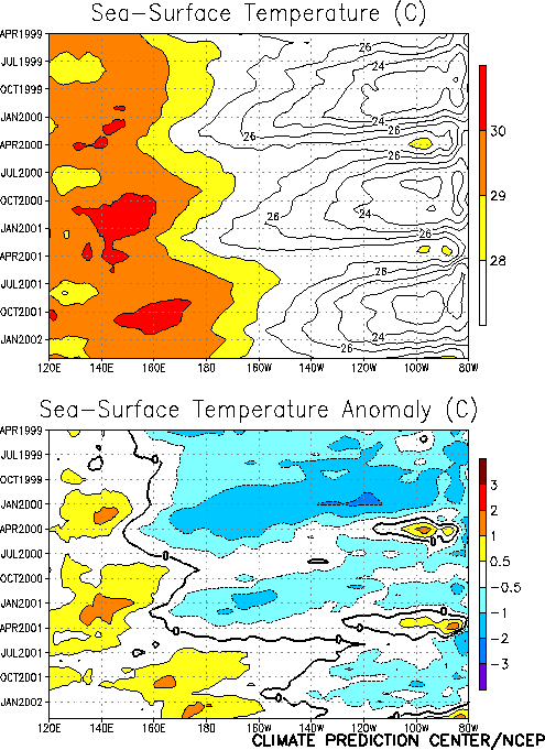
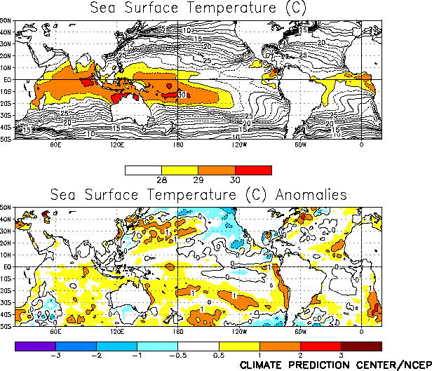
episode continued in the equatorial Pacific during March 2002, with warmer-than-normal sea
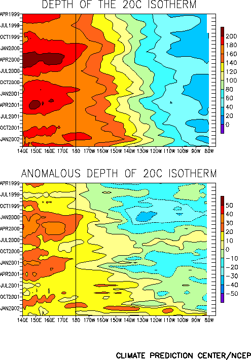
surface temperatures (Fig. T9) and subsurface temperatures
(Fig. T15) observed throughout the equatorial Pacific. An
area of equatorial sea surface temperature anomalies exceeding +1° C continued to expand
westward from the South American coast during the month (Figs. T9,
T18). Ocean surface temperatures remained as much as 2-3° C
(up to 6°F) above average near the coasts of Ecuador and northern Peru during March. This
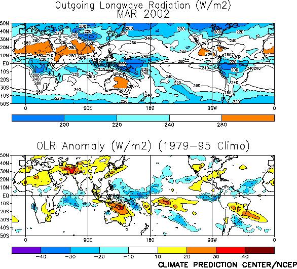
warming has been accompanied by an increase in rainfall over the extreme eastern tropical
Pacific, including the Galapagos Islands (Figs. T25, E3). As a result, parts of South America (Ecuador and northern
Peru) are already experiencing El Niño-related impacts. Persistent rain and cloudiness
have also been observed over the tropical west-central Pacific, from Papua New Guinea
eastward to the date line (180° W) (Figs. T25, E3).
It is important to emphasize that these conditions represent the early stages of
El Niño and that mature El Niño conditions will take at least several more months
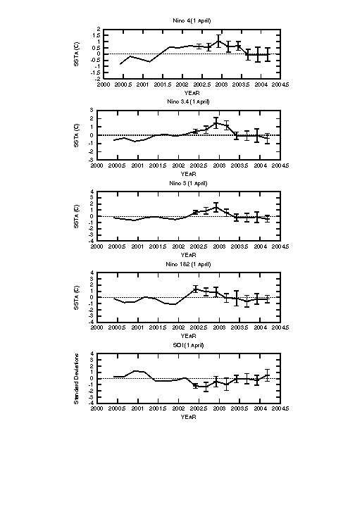
to develop. Several of the atmospheric indices, including both lower-tropospheric and
upper-tropospheric wind indices, do not reflect El Niño/ Southern Oscillation (ENSO)
conditions at this time (Table T1). However, these indices
are often inconsistent in the early stages of El Niño.
The warming of surface and subsurface waters in the eastern equatorial Pacific was due
to the arrival of an oceanic Kelvin wave that propagated eastward from the central
equatorial Pacific starting in mid-December. This Kelvin wave was triggered by tropical
intraseasonal (30-60 day) fluctuations associated with the Madden Julian Oscillation
(MJO). Whereas MJO activity was evident throughout the global tropics during much of the
NH winter, no MJO activity was observed during March 2002 . However, the period from now
thru May is a critical time, when MJO activity can generate equatorial westerly wind
bursts capable of producing Kelvin wave activity. Without such activity a continued slow
evolution towards mature El Niño conditions would be expected to occur through the spring
and summer of 2002.
The latest statistical and coupled model predictions (Figs. F1,
F2, F3, F4a,
F4b, F5, F6, F7, F8,
F9) show a spread from near-normal conditions to
moderate warm-episode conditions during the remainder of 2002. The coupled models and some
statistical techniques that incorporate subsurface oceanic conditions indicate a slow
evolution to weak or moderate warm-episode (El Niño) conditions during the next several
months. Other techniques indicate that conditions will remain near normal for the
remainder of 2002. Based on the recent evolution of the observed oceanic conditions and
the SST predictions, it appears most likely that further development toward mature El
Niño conditions will occur over the next 3-9 months.
Weekly updates of SST, 850-hPa wind, OLR, and the equatorial subsurface temperature
structure are available on the Climate Prediction Center homepage at:
http://www.cpc.ncep.noaa.gov (Weekly Update).
|


