Extratropical Highlights - March 1999
1. Northern Hemisphere
a. North Pacific
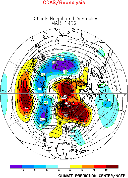
The circulation over the North Pacific during March featured below-normal heights at
high latitudes and above-normal heights in the middle latitudes (Fig.
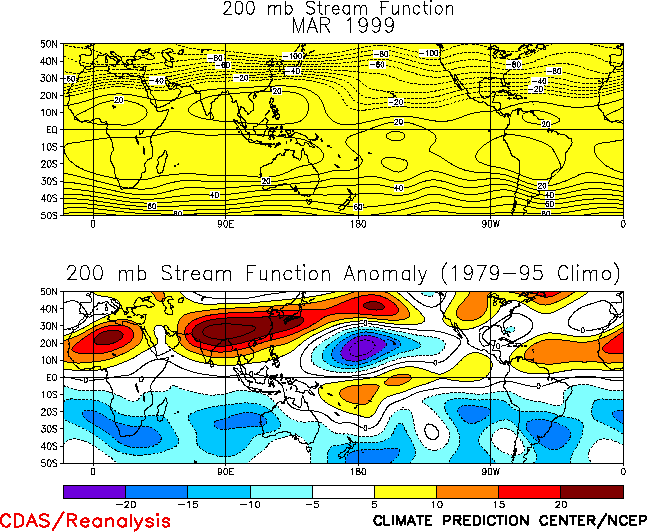
E9). In the subtropics, it also featured anticyclonic (cyclonic) circulation
anomalies across southern Asia (the central North Pacific) (Fig.
T22, bottom). Each of these features was also present during February. Overall,
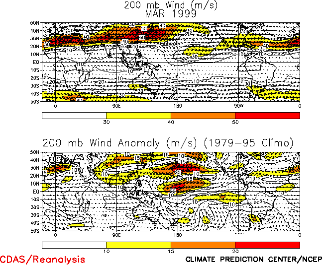
these conditions reflected a pronounced westward retraction of the East Asian jet stream
toward Asia, along with a slight northward shift of the jet (Fig.
T21). They also reflected a retraction of the mean subtropical ridge to well west
of the date line and a strengthening of the mid-Pacific trough in the region east of the
date line. Accompanying this structure was an extremely well-developed diffluent flow and
jet exit region across the eastern subtropical North Pacific. The conditions in the middle
latitudes and subtropics are linked to the increased east-west gradient in deep tropical
heating associated with ongoing strong La Niña conditions. Similar circulation features
were also evident over the subtropical South Pacific.
At higher latitudes a persistent upper-level trough across the North Pacific during the
past two months has completely suppressed the high-latitude blocking activity which is
typical of wintertime La Niña conditions, and therefore has also contributed to
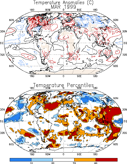
above-normal temperatures and to a reduced frequency of cold-air outbreaks across Canada
and portions of the U.S. (Fig. E1). Accompanying these
conditions, an increased westerly flow of marine air has persisted during the past few
months in western Canada and the northwestern United States, which has contributed to
above-normal precipitation in these regions.
A large region of positive height anomalies at upper levels has also persisted across
central and eastern Canada during the past two months, in association with a reduced
strength of the climatological mean Hudson Bay Low (Fig. E9).
This pattern has contributed to above-normal temperatures across eastern Canada during the
period.
b. North Atlantic, Europe, Asia
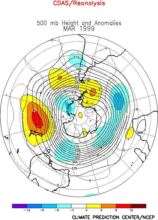
The circulation during March featured above-normal heights across the high latitudes of
the North Atlantic (Fig. E9 ) and below-normal heights
over the southeastern North Atlantic. This circulation reflected a dramatic change from
the strong positive phase of the North Atlantic Oscillation (NAO) that had previously
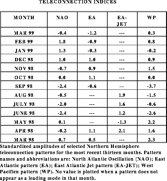
prevailed for the past three months (Table E1, Figs. E6, E7).
Farther east, a large-amplitude trough at upper levels covered most of central Russia
and Siberia during the month. This feature contributed to significantly below-normal
temperatures throughout the region, with values averaging more than 6°C below normal in
many locations (Fig. E1). These conditions are opposite
to those observed in February, which featured above-normal heights and significantly
above-average temperatures throughout the region.
2. Southern Hemisphere
The Southern Hemisphere extratropical circulation during March again featured
above-normal heights across the middle latitudes of the South Pacific and below-normal
heights across the high latitudes of the eastern South Pacific (Fig.
E15). At lower latitudes, the circulation featured a well-defined subtropical
ridge over the eastern Indian Ocean and Australia and a large-amplitude trough east of the
date line (Fig. T22). Overall, these conditions were
associated with abnormally weak winds at jet stream level across the
middle latitudes of the eastern South Pacific (Fig. T21),
and a poleward shift of the main jet stream to higher latitudes. These conditions and
their Northern Hemisphere counterparts are consistent with ongoing strong La Niña
conditions.
Another recurring feature of Pacific cold episodes is enhanced rainfall over southern
Africa during that region's rainy season, which typically lasts from October - April.
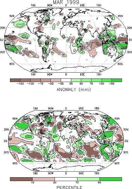
During March, area-average totals in this region were again above normal (Fig. E4), with most of the enhanced rainfall occurring
in the climatologically wet regions of eastern South Africa, southern Mozambique and
southern Tanzania (Fig. E3). Rainfall has averaged well
above-normal across eastern South Africa since November 1998, following a delayed onset to
the rainy season in October (Fig. E4).
|


