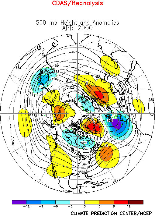
The circulation during April featured above-average
heights across the east-central North Pacific, over the western United States, over the
western North Atlantic and over much of northwestern Russia (Fig.
E9). The circulation also featured below-average heights over the Kamchatka
Peninsula, over Hudson Bay and over the eastern North Atlantic. In the subtropics, there
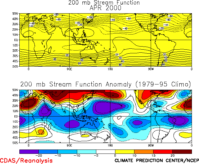
remains considerable symmetry of the upper-level circulation anomalies in both hemispheres
(Fig. T22, bottom). The most notable aspect of this
anomaly pattern has been a persistent pattern of anticyclonic circulation anomalies
extending eastward in the Northern Hemisphere from the Atlantic Ocean to Asia and in the
Southern Hemisphere from the Atlantic Ocean eastward to Australia. This extraordinarily
persistent pattern has prevailed since mid-1998 in association with ongoing La Niña
conditions, and is a leading mode of atmospheric variability on both the interannual and
interdecadel time scales.
a. North America
Above-average heights covered the western half of the United States during April, while
near-average heights were observed in the East (Fig. E9).
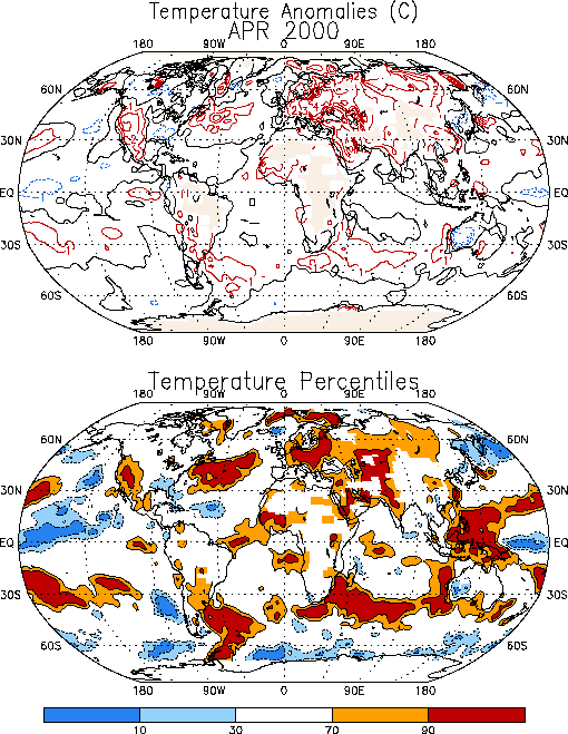
This anomaly pattern contributed to well above-average temperatures (Fig.
E1) in the western United States, in association with the amplified upper-level
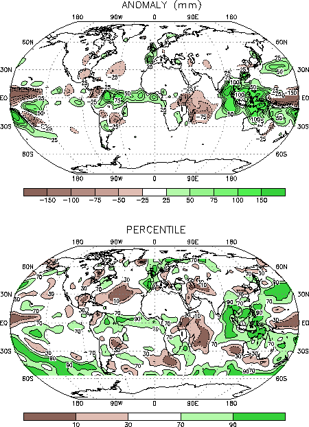
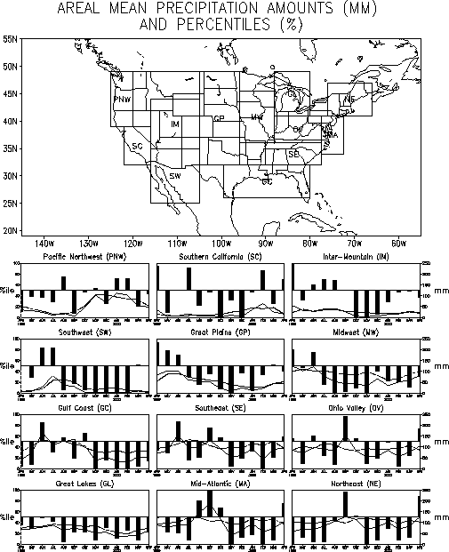
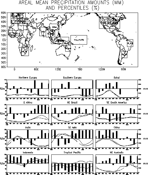
ridge axis in that region. It also contributed to substantially above-average rainfall (Fig. E3) in the Northeast for the first time since September 1999
(Fig. E5). This region was situated downstream of the mean
trough axis in an area of large-scale ascending motion and increased storminess.
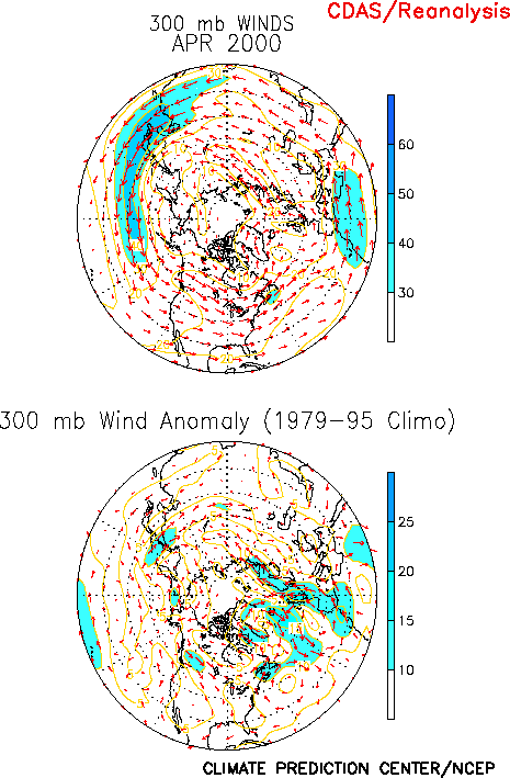
This anomalous height field was also associated with enhanced northwesterly and
northerly flow that extended across the central part of the country and into the Southeast
(Fig. E10, right). This flow pattern, combined with the
relative proximity of these areas to the downstream trough axis, contributed to
below-average rainfall in the Southeast and portions of the central U.S. It also
contributed to cooler-than-average temperatures in the Southeast.
The Midwest and Great Lakes regions have recorded below-normal rainfall since July 1999
(Fig. E5). Considerable dryness has also prevailed in the
Gulf Coast region since November 1999. In the Mid-Atlantic and Northeast regions, the
above-average rainfall during April broke a 5-month stretch of significantly below-average
precipitation that began in November 1999.
2. Europe/ Asia
Most of central and eastern Europe, as well as much of central and southwestern Russia,
experienced milder-than-average temperatures during April (Fig. E1).
Temperatures were above the 90th percentile across northern and northeastern
Europe, and over southwestern Russia in the region east of the Caspian Sea. This warmth
was associated with an anomalous upper-level circulation pattern featuring a large-scale
trough over the eastern North Atlantic and a broad ridge over western Russia (Fig. E9). This anomalous circulation also contributed to well
above-average rainfall in western Europe, with totals exceeding the 90th
percentile in Great Britain and Portugal (Fig. E3).
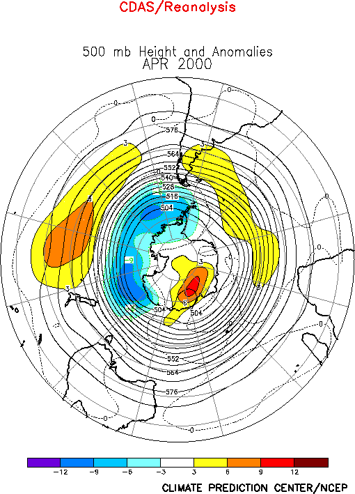
2. Southern Hemisphere
The Southern Hemisphere circulation during April (Fig. E15)
featured above-average heights over the middle latitudes of both the central South Pacific
and South Atlantic, and below-normal heights over the high latitudes of the South Pacific.
Much of the central latitudes have experienced above-average heights for over a year, in
association with an extremely persistent pattern of anticyclonic circulation anomalies in
both hemispheres extending from the Atlantic ocean eastward to Australasia (See Northern
Hemisphere Highlights above).
Since January southeastern Africa has recorded significantly above-average rainfall (Fig. E4), in association with this anomalous circulation. This
excessive rainfall occurred during the region’s rainy season, and resulted in
large-scale flooding across much of central Mozambique in March.
In early April, the central and northern coastal regions of Mozambique were also
impacted by Tropical Cyclone Hudah. This system brought heavy rains to the coastal areas,
but did not trigger a resurgence of large-scale flooding. Unfortunately, TC Hudah had
previously made a direct hit on northeastern Madagascar in early April, destroying the
towns of Antalaha and Cap Est.
In Australia, below-average temperatures were observed across the western half of the
continent, with temperatures averaging in the lowest 30th percentile throughout
the region (Fig. E1). Temperatures have been
below normal in this area since November 1999. This prolonged period of below-average
temperatures has been accompanied by above-average rainfall throughout the period.


