|
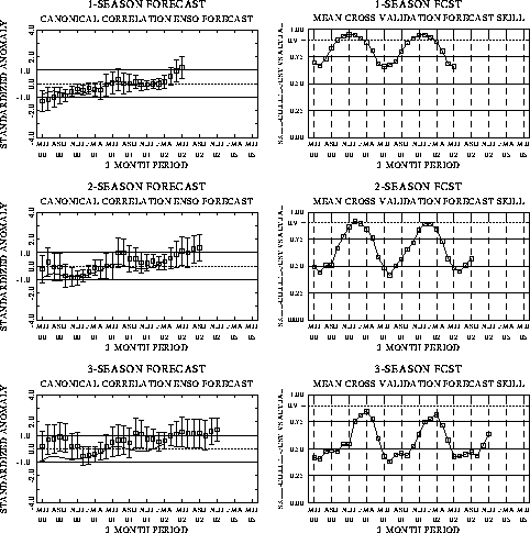
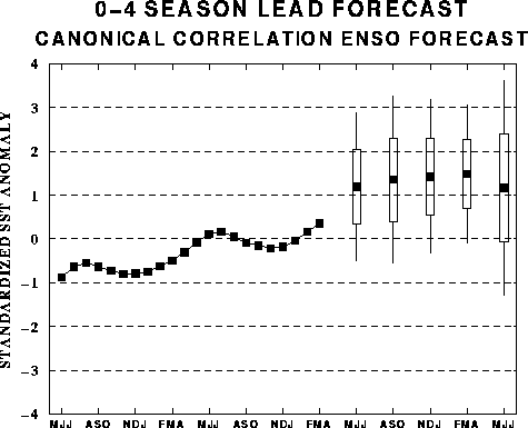
The canonical correlation analysis (CCA) forecast
of SST in the central Pacific (Barnett et al. 1988, Science, 241, 192-196;
Barnston and Ropelewski 1992, J. Climate, 5, 1316-1345), is shown in Figs.
F1 and F2. This forecast is produced
routinely by the Prediction Branch of the Climate Prediction Center. The predictions from
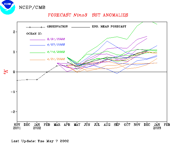
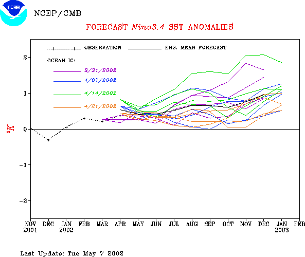
the National Centers for Environmental Prediction (NCEP) coupled ocean/atmosphere model
(Ji et al. 1998, Mon. Wea. Rev, 126, 1022-1034) are presented in Figs. F3 and F4a, F4b.
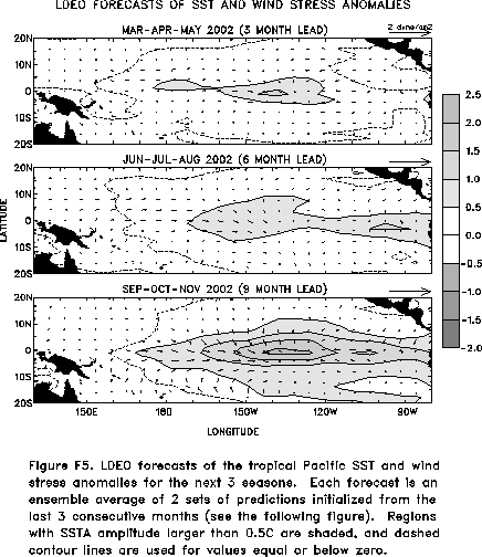
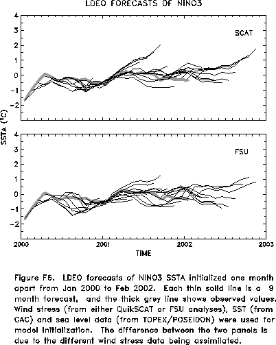
Predictions from the latest version of the LDEO model (Chen, D., M. A. Cane, S. E. Zebiak,
Rafael Canizares and A. Kaplan, 2000, Geophys. Res. Let., accepted) are shown in Figs.
F5 and F6. Predictions using linear
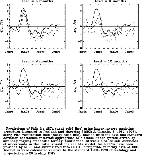
inverse modeling (Penland and Magorian 1993, J. Climate, 6, 1067-1076) are
shown in Figs. F7 and F8.
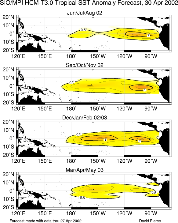
Predictions from the Scripps / Max Planck Institute (MPI) hybrid coupled model (Barnett et
al. 1993, J. Climate, 6, 1545-1566) are shown in Fig. F9.
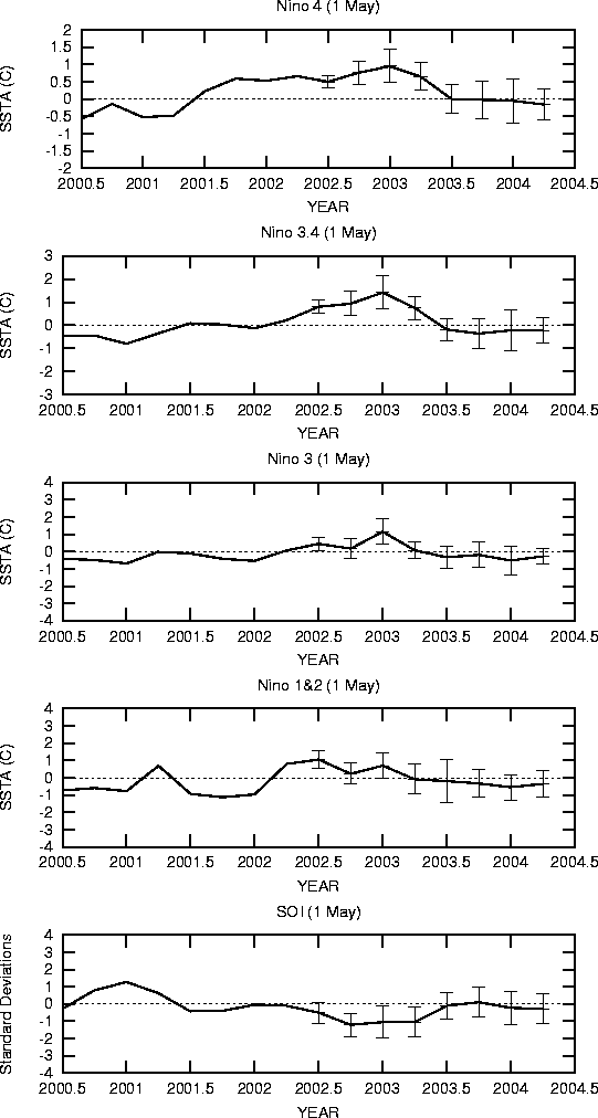
Predictions from the ENSO-CLIPER statistical model (Knaff, J. A. and C. W. Landsea
1997, Wea. Forecasting, 12, 633-652) are shown in Fig. F10.
The CPC and the contributors to the Forecast
Forum caution potential users of this predictive information that they can expect only
modest skill.
Outlook
Based on the recent evolution of the observed
oceanic surface and subsurface conditions and the SST predictions, it appears most likely
that a gradual warming of the tropical Pacific will continue over the next several months,
and that weak-to-moderate El Niño conditions are likely by the end of 2002.
Discussion
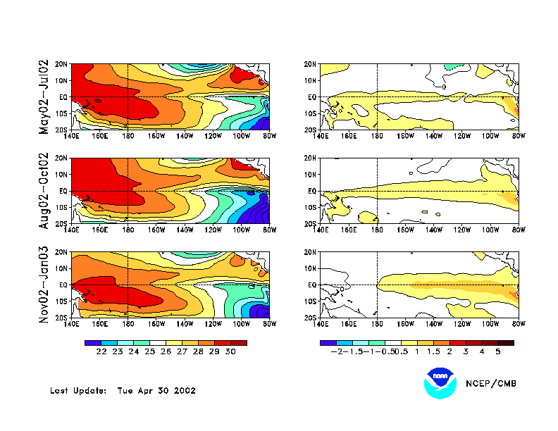
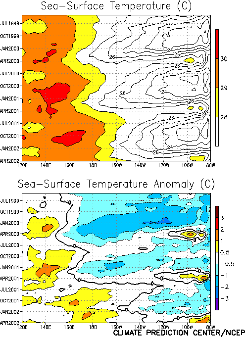
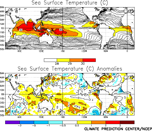
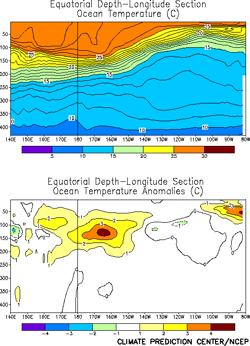
Warmer-than-normal sea surface (Figs. T9, T18) and subsurface (Fig. T17)
temperatures were observed throughout most of the equatorial Pacific during April 2002.
Sea surface temperature anomalies were up to 2°C warmer than average in the region
between the Galapagos Islands and the South American coast, and greater than 1°C warmer
than average immediately to the west of 180°W (Fig. T18).
Although there was considerable warming in the eastern equatorial Pacific during
February-April, which resulted in locally heavy rainfall along the coasts of Ecuador and
northern Peru, there was relatively little change in SSTs or subsurface temperature
anomalies in regions farther west during this period (Figs. T9,
T15). Consistent with this lack of evolution in the central
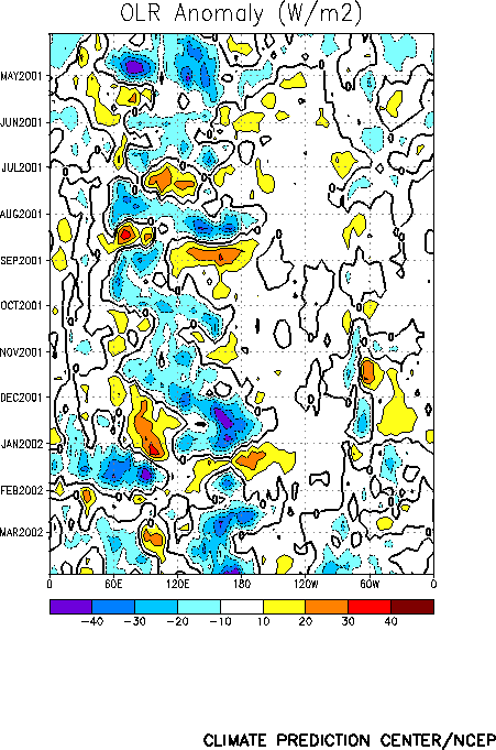
equatorial Pacific, atmospheric indices for low-level winds, sea level pressure (SOI) and
precipitation (OLR) continue to indicate near-normal conditions (Table
T1). However, these indices are often inconsistent in the early stages of El Niño
development. The Madden-Julian Oscillation (MJO) is an important source of variability
that can contribute to a more rapid evolution toward El Niño through related fluctuations
in low-level winds and precipitation over the western and central equatorial Pacific. An
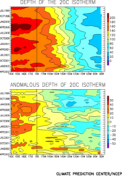
eastward-propagating oceanic Kelvin wave, initiated by strong MJO activity in late 2001 (Figs.
T11, T12), resulted in the rapid
warming of surface and subsurface waters that was observed along the coasts of Ecuador and
northern Peru in early February (Fig. T9). Since that time
MJO activity has weakened considerably and there has been no additional significant Kelvin
wave activity. Without such activity a continued slow evolution towards mature El Niño
conditions is likely.
This assessment agrees well with the latest statistical and coupled model predictions (Figs.
F1, F2, F3,
F4a, F4b, F5, F6, F7,
F8, F9) which show a
spread from near-normal conditions to moderate warm-episode conditions during the
remainder of 2002. The coupled models and some statistical techniques that incorporate
subsurface oceanic conditions indicate a slow evolution to weak or moderate warm-episode
(El Niño) conditions by the end of 2002. Other techniques indicate that conditions will
remain near normal for the remainder of 2002. Based on the recent evolution of the
observed oceanic conditions and the SST predictions, it appears most likely that a gradual
warming will continue over the next several months, and that weak-to-moderate El Niño
conditions are likely by the end of 2002. It is important to add that a weak or moderate
El Niño would feature much weaker global impacts than were experienced during the very
strong 1997-98 El Niño.
Weekly updates of SST, 850-hPa wind, OLR, and the
equatorial subsurface temperature structure are available on the Climate Prediction Center
homepage at: http://www.cpc.ncep.noaa.gov (Weekly Update).
|


