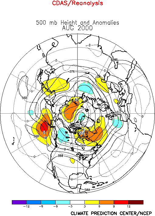
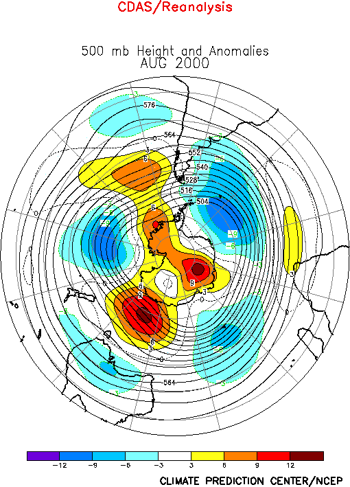
| The anomalous circulation during
August featured above-normal heights over much of the region poleward of 45°N, with the
primary positive anomaly centers situated over the Aleutian Islands, the high latitudes of
the North Atlantic, southern Russia, and eastern Siberia (Fig. E9).
In contrast the areas of negative height anomalies were confined to western Canada, the
extreme eastern North Atlantic and portions of northern Russia. This predominance of
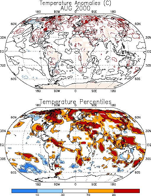
above-average heights was associated with warmer-than-average surface temperatures across
much of the middle and high latitudes (Fig. E1), with the
exceptions being near-average temperatures over China and below-average temperatures over
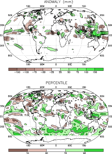
western Canada and the northeastern United States. The prominent precipitation anomalies
during the month reflected a continuation of significantly below-average rainfall across
the southern United States (Fig. E3), and above-average
rainfall over central Canada, eastern China, and the Yangtze River Valley of central
China. a. North America
Weak positive 500-hPa height anomalies covered the western and central United States
during August (Fig. E9), in association with a slightly
amplified summertime ridge across the middle and southern portions of the country. This
circulation contributed to a continuation of extremely hot (Fig. E1)
and dry (Fig. E3) conditions across the southern and
central states, with the most extreme departures found in the area of northern Texas and
portions of Oklahoma.
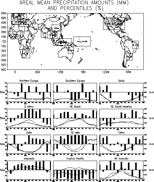
The largest area-averaged rainfall deficits (precipitation totals below the 10th
percentile) during August were observed in the Southwest, the Great Plains, and the
Midwest regions (Fig. E5). Below-average rainfall totals
were also observed in the Gulf Coast region, which has recorded rainfall deficits in all
but one month since November 1999. Similarly, the Intermountain region has recorded
considerably below-average precipitation since October 1999, which contributed to numerous
and vast wildfires across the region during the past few months.
B. Europe
Much of southern and central Europe, and southwestern Russia experienced above-average
surface temperatures during August (Fig. E1), with
anomalies exceeding the 90th percentile from the Alps eastward to the Caspian Sea. This
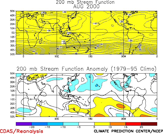
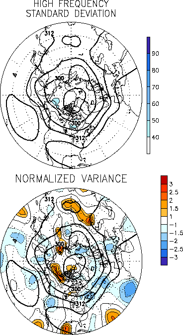
warmth was associated with an anomalous upper-level anticyclonic circulation (Fig. T22, bottom) and an overall reduced strength of the storm
track (Fig. E13, right) throughout the region.
Rainfall was near-average across most of Eurasia during August, with the primary
anomalies reflecting below-average rains in the area east of the Alps and above-average
rains in central and eastern China. Area-averaged rainfall totals have been above-average
in China since June (Fig. E4).
2. Southern Hemisphere
Below-average heights dominated the middle
latitudes of the southern Hemisphere during August, while an anomalous wave-3 pattern was
evident at higher latitudes (Fig. E15). This pattern was
accompanied by a continuation of blocking activity over the high latitudes of the eastern
South Pacific, which contributed to an abnormal influx of cold air into southeastern
Brazil (Fig. E1). Similar conditions also prevailed during
July, which has resulted in portions of southeastern Brazil recording temperatures below
the 30th percentile for the second consecutive month.
In Australia near-average rainfall and temperatures were observed over much of the
continent during the month. In contrast, exceptionally warm and wet conditions were
observed in the oceanic area immediately south of the continent. This region coincided
with the superposition of 1) an area of enhanced split flow and enhanced upper-level
diffluence within the very pronounced exit region of the Indian Ocean jet stream at
500-hPa (Fig. E15). |


